

266
11 : Teerasit Kasetkasem, Manoj K. Arora, Pramod K. Varshney
11.4.1
Experiment 1: Sub-pixel Mapping from Multispectral Data
A small dataset from multi-spectral (spatial resolution 4 m) and panchromatic
(spatial resolution 1 m) sensors onboard the IKONOS satellite, acquired in
2001, has been used in this example. It consists of (26 x 60) pixels of 4 bands
of the multi-spectral image in blue, green, red and near infrared (NIR) regions
and (97 x 237) pixels of the single band PAN image, and covers a portion of
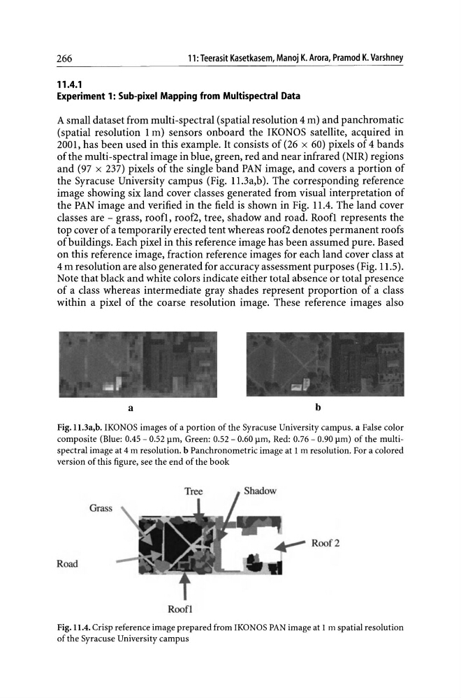
the Syracuse University campus (Fig. 11.3a,b). The corresponding reference
image showing six land cover classes generated from visual interpretation of
the PAN image and verified in the field is shown in Fig. 11.4. The land cover
classes are - grass, roofI, roof2, tree, shadow and road. Roofl represents the
top cover of a temporarily erected tent whereas roof2 denotes permanent roofs
of buildings. Each pixel in this reference image has been assumed pure. Based
on this reference image, fraction reference images for each land cover class at
4 m resolution are also generated for accuracy assessment purposes (Fig. 11.5).
Note that black and white colors indicate either total absence or total presence
of a class whereas intermediate gray shades represent proportion of a class
within a pixel of the coarse resolution image. These reference images also
a
b
Fig.l1.3a,b. IKONOS images of a portion of the Syracuse University campus. a False color
composite (Blue: 0.45 - 0.52 J.lm, Green: 0.52 - 0.60 J.lm, Red: 0.76 - 0.90 J.lm) of the multispectral image at 4 m resolution. b Panchronometric image at 1 m resolution. For a colored
version of this figure, see the end of the book
Road
Roof!
Fig. 11.4. Crisp reference image prepared from IKONOS PAN image at 1 m spatial resolution
of the Syracuse University campus
11 : Teerasit Kasetkasem, Manoj K. Arora, Pramod K. Varshney
11.4.1
Experiment 1: Sub-pixel Mapping from Multispectral Data
A small dataset from multi-spectral (spatial resolution 4 m) and panchromatic
(spatial resolution 1 m) sensors onboard the IKONOS satellite, acquired in
2001, has been used in this example. It consists of (26 x 60) pixels of 4 bands
of the multi-spectral image in blue, green, red and near infrared (NIR) regions
and (97 x 237) pixels of the single band PAN image, and covers a portion of
the Syracuse University campus (Fig. 11.3a,b). The corresponding reference
image showing six land cover classes generated from visual interpretation of
the PAN image and verified in the field is shown in Fig. 11.4. The land cover
classes are - grass, roofI, roof2, tree, shadow and road. Roofl represents the
top cover of a temporarily erected tent whereas roof2 denotes permanent roofs
of buildings. Each pixel in this reference image has been assumed pure. Based
on this reference image, fraction reference images for each land cover class at
4 m resolution are also generated for accuracy assessment purposes (Fig. 11.5).
Note that black and white colors indicate either total absence or total presence
of a class whereas intermediate gray shades represent proportion of a class
within a pixel of the coarse resolution image. These reference images also
a
b
Fig.l1.3a,b. IKONOS images of a portion of the Syracuse University campus. a False color
composite (Blue: 0.45 - 0.52 J.lm, Green: 0.52 - 0.60 J.lm, Red: 0.76 - 0.90 J.lm) of the multispectral image at 4 m resolution. b Panchronometric image at 1 m resolution. For a colored
version of this figure, see the end of the book
Road
Roof!
Fig. 11.4. Crisp reference image prepared from IKONOS PAN image at 1 m spatial resolution
of the Syracuse University campus