

300
6 Wave Transformation in Shallow Water
y
)(
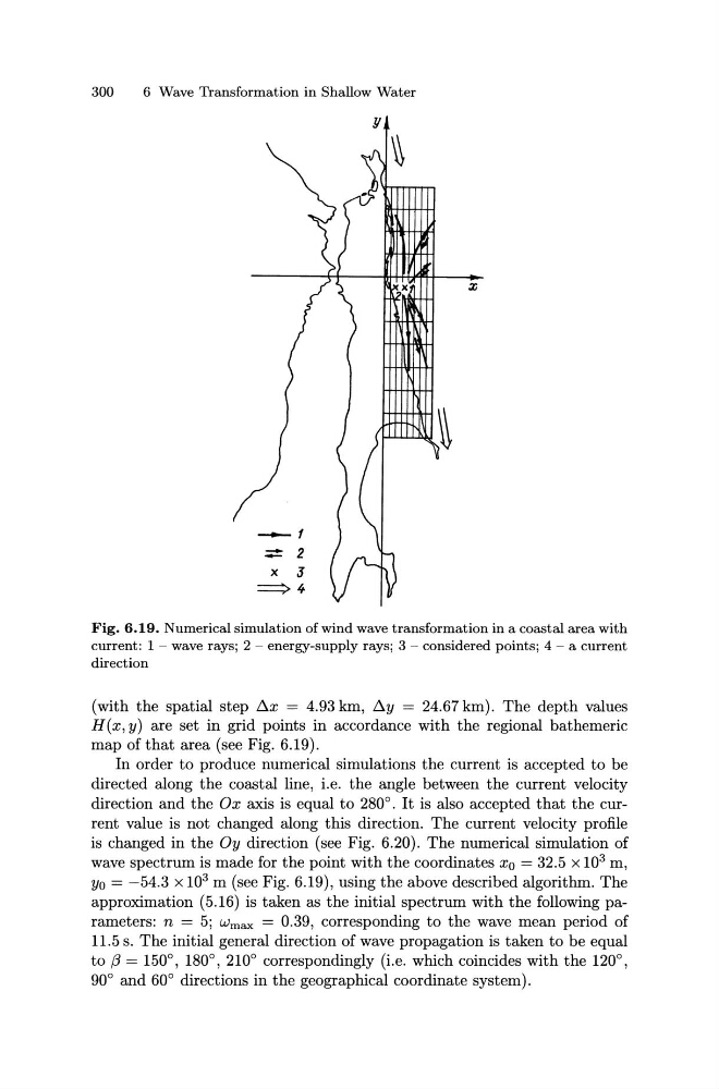
Fig. 6.19. Numerical simulation of wind wave transformation in a coastal area with
current: 1 - wave rays; 2 - energy-supply rays; 3 - considered points; 4 - a current
direction
(with the spatial step Ax = 4.93 km, Ay = 24.67 km). The depth values
H(x, y) are set in grid points in accordance with the regional bathemeric
map of that area (see Fig. 6.19).
In order to produce numerical simulations the current is accepted to be
directed along the coastal line, i.e. the angle between the current velocity
direction and the Ox axis is equal to 280°. It is also accepted that the current value is not changed along this direction. The current velocity profile
is changed in the Oy direction (see Fig. 6.20). The numerical simulation of
wave spectrum is made for the point with the coordinates x0 = 32.5 x 10 3 m,
y0 = -54.3 x 10 3 m (see Fig. 6.19), using the above described algorithm. The
approximation (5.16) is taken as the initial spectrum with the following parameters: n = 5; Wmax = 0.39, corresponding to the wave mean period of
11.5 s. The initial general direction of wave propagation is taken to be equal
to f3 = 150°, 180°, 210° correspondingly (i.e. which coincides with the 120°,
90° and 60° directions in the geographical coordinate system).
6 Wave Transformation in Shallow Water
y
)(
Fig. 6.19. Numerical simulation of wind wave transformation in a coastal area with
current: 1 - wave rays; 2 - energy-supply rays; 3 - considered points; 4 - a current
direction
(with the spatial step Ax = 4.93 km, Ay = 24.67 km). The depth values
H(x, y) are set in grid points in accordance with the regional bathemeric
map of that area (see Fig. 6.19).
In order to produce numerical simulations the current is accepted to be
directed along the coastal line, i.e. the angle between the current velocity
direction and the Ox axis is equal to 280°. It is also accepted that the current value is not changed along this direction. The current velocity profile
is changed in the Oy direction (see Fig. 6.20). The numerical simulation of
wave spectrum is made for the point with the coordinates x0 = 32.5 x 10 3 m,
y0 = -54.3 x 10 3 m (see Fig. 6.19), using the above described algorithm. The
approximation (5.16) is taken as the initial spectrum with the following parameters: n = 5; Wmax = 0.39, corresponding to the wave mean period of
11.5 s. The initial general direction of wave propagation is taken to be equal
to f3 = 150°, 180°, 210° correspondingly (i.e. which coincides with the 120°,
90° and 60° directions in the geographical coordinate system).