

5. 7 Wind Wave Transformation in Cross-Velocity Shear Current
205
full-scale data is connected with the experimental complexity. It is necessary to conduct synchronous measurements of the non-uniform spatial field
of current velocity and spatial wind wave spectra. This unique experiment
was done by researchers from the St. Petersburg State University (Russia)
by aerial photography.
The main purpose of aerial photography is to study the structure of water
flow in the strait between two islands. The general strait area is of approximately rectangular form with a width in its narrow part of 22 km and a length
of 25 km. There are two types of aerial photography: water surface survey and
current survey, with floats used along the line between the nearest points of
the islands' opposite shores. The route length is about 22 km. The aerial photography is made at the scale of 1 : 15,000. The straits' area is observed with
the help of four parallel routes across the strait. Both ends of the islands are
linked with edges of these routes.
The aim is to obtain a flare portion as full as possible on the aerial films
of the strait surface survey. This allows one to obtain spectra of the sea surface optical representation using the Methods of Examining Marine Currents
from an Airplane (1964). These spectra can be connected with spectra of sea
surface slopes (Grushin et al., 1986).
The current surveys are made along single routes and only along one
direction across the strait at its narrowest place. The routes are linked with
both shore ends. The floats are dropped every 500 m. Then a direct survey
of the entire float series is made twice with a 15-20 min interval. Diagrams
of the float motion vectors are obtained for every route after the received
data have been processed. The error of determining the current velocities
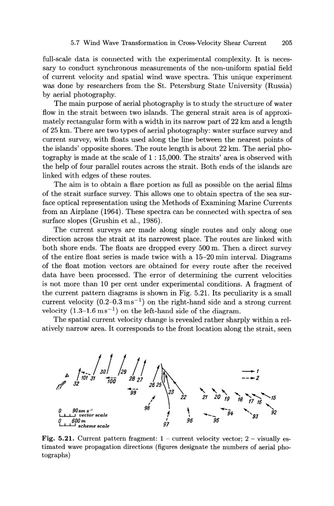
is not more than 10 per cent under experimental conditions. A fragment of
the current pattern diagrams is shown in Fig. 5.21. Its peculiarity is a small
current velocity (0.2-0.3 ms- 1 ) on the right-hand side and a strong current
velocity (1.3-1.6 ms- 1 ) on the left-hand side of the diagram.
The spatial current velocity change is revealed rather sharply within a relatively narrow area. It corresponds to the front location along the strait, seen
; Jro;-/{J. f! J,,~\3
,
22
I
I
0
90sms· 1
98
~
\
L..L.J.....J vector scale
1
1
0
600m
1
96
L..L.J.....J scheme scale
97
Fig. 5.21. Current pattern fragment: 1 - current velocity vector; 2 - visually estimated wave propagation directions (figures designate the numbers of aerial photographs)
205
full-scale data is connected with the experimental complexity. It is necessary to conduct synchronous measurements of the non-uniform spatial field
of current velocity and spatial wind wave spectra. This unique experiment
was done by researchers from the St. Petersburg State University (Russia)
by aerial photography.
The main purpose of aerial photography is to study the structure of water
flow in the strait between two islands. The general strait area is of approximately rectangular form with a width in its narrow part of 22 km and a length
of 25 km. There are two types of aerial photography: water surface survey and
current survey, with floats used along the line between the nearest points of
the islands' opposite shores. The route length is about 22 km. The aerial photography is made at the scale of 1 : 15,000. The straits' area is observed with
the help of four parallel routes across the strait. Both ends of the islands are
linked with edges of these routes.
The aim is to obtain a flare portion as full as possible on the aerial films
of the strait surface survey. This allows one to obtain spectra of the sea surface optical representation using the Methods of Examining Marine Currents
from an Airplane (1964). These spectra can be connected with spectra of sea
surface slopes (Grushin et al., 1986).
The current surveys are made along single routes and only along one
direction across the strait at its narrowest place. The routes are linked with
both shore ends. The floats are dropped every 500 m. Then a direct survey
of the entire float series is made twice with a 15-20 min interval. Diagrams
of the float motion vectors are obtained for every route after the received
data have been processed. The error of determining the current velocities
is not more than 10 per cent under experimental conditions. A fragment of
the current pattern diagrams is shown in Fig. 5.21. Its peculiarity is a small
current velocity (0.2-0.3 ms- 1 ) on the right-hand side and a strong current
velocity (1.3-1.6 ms- 1 ) on the left-hand side of the diagram.
The spatial current velocity change is revealed rather sharply within a relatively narrow area. It corresponds to the front location along the strait, seen
; Jro;-/{J. f! J,,~\3
,
22
I
I
0
90sms· 1
98
~
\
L..L.J.....J vector scale
1
1
0
600m
1
96
L..L.J.....J scheme scale
97
Fig. 5.21. Current pattern fragment: 1 - current velocity vector; 2 - visually estimated wave propagation directions (figures designate the numbers of aerial photographs)