

467
Exploring ArcGIS Explorer
highway? What elements of visual image interpretation aid in discerning
what this is?
3. To get more information about various features, you can add the labels
and roads available through Bing Maps to the imagery. From the Home
tab, select the Basemap option. From the new available options, select
Bing Maps Hybrid.
4. AGX will switch to a new set of data being streamed to you—not only the
images, but labels and other information as well. Examine the new scene
of Tujunga Valley and answer Question 15.7 (this will probably also help
confirm your answer to Question 15.6).
Question 15.7 What is the name and number of the interstate that goes
through the valley?
15.4 Geocoding Addresses and Basic Spatial Analysis
with ArcGIS Explorer
1. Back in Chapter 8, you looked at geocoding addresses and routing
between them. AGX contains these features as well as several types of
GIS spatial analysis functions. To get started, we’ll begin at a Hollywood
landmark, Grauman’s Chinese Theatre (for more information about the
theatre, visit http://www.manntheatres.com/chinese).
2. Bring up the Find dialog box again (as in Section 15.1) and search for
the theater’s address: 6925 Hollywood Boulevard, CA 90028. Click
the Search button and AGX will change the view so that it centers on
the theater, placing a white pushpin in its location along Hollywood
Boulevard.
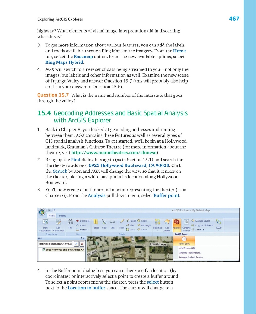
3. You’ll now create a buffer around a point representing the theater (as in
Chapter 6). From the Analysis pull-down menu, select Buffer point.
4. In the Buffer point dialog box, you can either specify a location (by
coordinates) or interactively select a point to create a buffer around.
To select a point representing the theater, press the select button
next to the Location to buffer space. The cursor will change to a
Exploring ArcGIS Explorer
highway? What elements of visual image interpretation aid in discerning
what this is?
3. To get more information about various features, you can add the labels
and roads available through Bing Maps to the imagery. From the Home
tab, select the Basemap option. From the new available options, select
Bing Maps Hybrid.
4. AGX will switch to a new set of data being streamed to you—not only the
images, but labels and other information as well. Examine the new scene
of Tujunga Valley and answer Question 15.7 (this will probably also help
confirm your answer to Question 15.6).
Question 15.7 What is the name and number of the interstate that goes
through the valley?
15.4 Geocoding Addresses and Basic Spatial Analysis
with ArcGIS Explorer
1. Back in Chapter 8, you looked at geocoding addresses and routing
between them. AGX contains these features as well as several types of
GIS spatial analysis functions. To get started, we’ll begin at a Hollywood
landmark, Grauman’s Chinese Theatre (for more information about the
theatre, visit http://www.manntheatres.com/chinese).
2. Bring up the Find dialog box again (as in Section 15.1) and search for
the theater’s address: 6925 Hollywood Boulevard, CA 90028. Click
the Search button and AGX will change the view so that it centers on
the theater, placing a white pushpin in its location along Hollywood
Boulevard.
3. You’ll now create a buffer around a point representing the theater (as in
Chapter 6). From the Analysis pull-down menu, select Buffer point.
4. In the Buffer point dialog box, you can either specify a location (by
coordinates) or interactively select a point to create a buffer around.
To select a point representing the theater, press the select button
next to the Location to buffer space. The cursor will change to a