

466
Chapter 15 What’s Next for Geospatial Technology?
11. Reset the Vertical Exaggeration level to about one-fourth of the way up
the slider. This level is good for this visualization part of the exercise, as
it will really make the mountains and valleys stand out. Even by looking
vertically down on the topos, you should be able to make out some
illusion of depth in the image (this is from the topos being draped over
AGX’s terrain).
12. Use the mouse and controls to fly around the region, zooming and
rotating where necessary.
Question 15.5 How does viewing draped imagery in perspective aid
in determining the differences in terrain between Tujunga Valley and the
nearby mountains? How does this aid in viewing the terrain and landscape
features of southern California?
15.3 Examining Imagery with ArcGIS Explorer
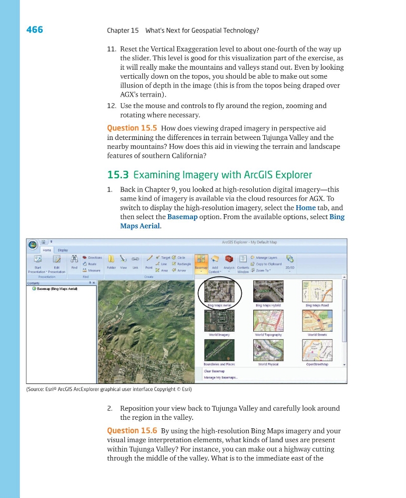
1. Back in Chapter 9, you looked at high-resolution digital imagery—this
same kind of imagery is available via the cloud resources for AGX. To
switch to display the high-resolution imagery, select the Home tab, and
then select the Basemap option. From the available options, select Bing
Maps Aerial.
2. Reposition your view back to Tujunga Valley and carefully look around
the region in the valley.
Question 15.6 By using the high-resolution Bing Maps imagery and your
visual image interpretation elements, what kinds of land uses are present
within Tujunga Valley? For instance, you can make out a highway cutting
through the middle of the valley. What is to the immediate east of the
(Source: Esri® ArcGIS ArcExplorer graphical user interface Copyright © Esri)
Chapter 15 What’s Next for Geospatial Technology?
11. Reset the Vertical Exaggeration level to about one-fourth of the way up
the slider. This level is good for this visualization part of the exercise, as
it will really make the mountains and valleys stand out. Even by looking
vertically down on the topos, you should be able to make out some
illusion of depth in the image (this is from the topos being draped over
AGX’s terrain).
12. Use the mouse and controls to fly around the region, zooming and
rotating where necessary.
Question 15.5 How does viewing draped imagery in perspective aid
in determining the differences in terrain between Tujunga Valley and the
nearby mountains? How does this aid in viewing the terrain and landscape
features of southern California?
15.3 Examining Imagery with ArcGIS Explorer
1. Back in Chapter 9, you looked at high-resolution digital imagery—this
same kind of imagery is available via the cloud resources for AGX. To
switch to display the high-resolution imagery, select the Home tab, and
then select the Basemap option. From the available options, select Bing
Maps Aerial.
2. Reposition your view back to Tujunga Valley and carefully look around
the region in the valley.
Question 15.6 By using the high-resolution Bing Maps imagery and your
visual image interpretation elements, what kinds of land uses are present
within Tujunga Valley? For instance, you can make out a highway cutting
through the middle of the valley. What is to the immediate east of the
(Source: Esri® ArcGIS ArcExplorer graphical user interface Copyright © Esri)