

395
Digital Terrain Analysis
7. You can save the tour by pressing the disk icon (the Save Tour) button.
Give it a name in the dialog box that opens. The saved tour will be added
to your Places box (just like all other Google Earth layers).
8. Put together a good tour (perhaps about a minute long) of the Grand
Canyon that shows off many of the area’s terrain features and save the
tour as a Google Earth layer.
Question 13.1 What areas in the Grand Canyon did you select for your
tour, and what terrain features did you highlight during the tour?
13.3 Vertical Exaggeration and Measuring Elevation
Height Values in Google Earth
Google Earth also allows you to alter the vertical exaggeration of the terrain layer.
As discussed on page 389, vertical exaggeration is used for visualization purposes.
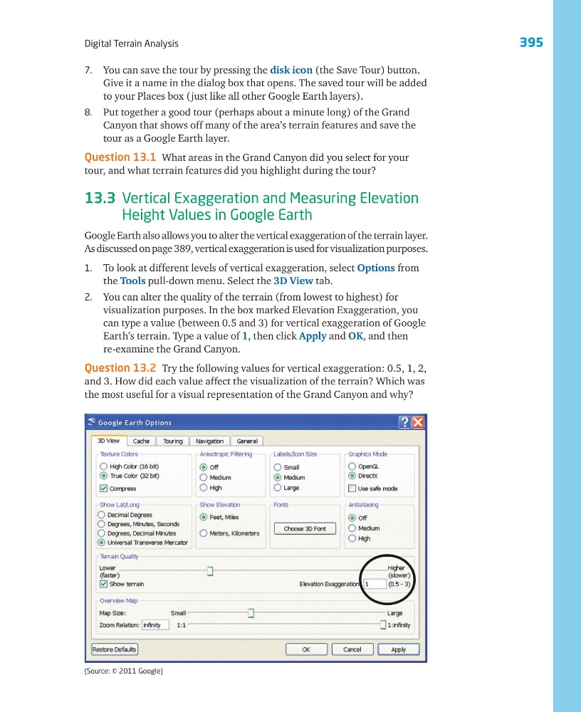
1. To look at different levels of vertical exaggeration, select Options from
the Tools pull-down menu. Select the 3D View tab.
2. You can alter the quality of the terrain (from lowest to highest) for
visualization purposes. In the box marked Elevation Exaggeration, you
can type a value (between 0.5 and 3) for vertical exaggeration of Google
Earth’s terrain. Type a value of 1, then click Apply and OK, and then
re-examine the Grand Canyon.
Question 13.2 Try the following values for vertical exaggeration: 0.5, 1, 2,
and 3. How did each value affect the visualization of the terrain? Which was
the most useful for a visual representation of the Grand Canyon and why?
(Source: © 2011 Google)
Digital Terrain Analysis
7. You can save the tour by pressing the disk icon (the Save Tour) button.
Give it a name in the dialog box that opens. The saved tour will be added
to your Places box (just like all other Google Earth layers).
8. Put together a good tour (perhaps about a minute long) of the Grand
Canyon that shows off many of the area’s terrain features and save the
tour as a Google Earth layer.
Question 13.1 What areas in the Grand Canyon did you select for your
tour, and what terrain features did you highlight during the tour?
13.3 Vertical Exaggeration and Measuring Elevation
Height Values in Google Earth
Google Earth also allows you to alter the vertical exaggeration of the terrain layer.
As discussed on page 389, vertical exaggeration is used for visualization purposes.
1. To look at different levels of vertical exaggeration, select Options from
the Tools pull-down menu. Select the 3D View tab.
2. You can alter the quality of the terrain (from lowest to highest) for
visualization purposes. In the box marked Elevation Exaggeration, you
can type a value (between 0.5 and 3) for vertical exaggeration of Google
Earth’s terrain. Type a value of 1, then click Apply and OK, and then
re-examine the Grand Canyon.
Question 13.2 Try the following values for vertical exaggeration: 0.5, 1, 2,
and 3. How did each value affect the visualization of the terrain? Which was
the most useful for a visual representation of the Grand Canyon and why?
(Source: © 2011 Google)