

389
How Can You Make Terrain Look More Realistic?
are referred to as base heights) to those locations on the image. In essence,
locations on the image are assigned a z-value that corresponds with the
terrain model.
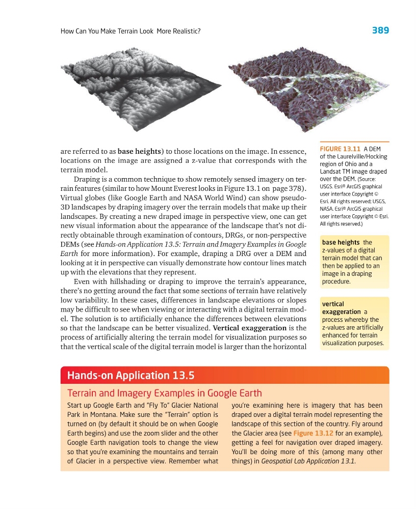
Draping is a common technique to show remotely sensed imagery on terrain features (similar to how Mount Everest looks in Figure 13.1 on page 378).
Virtual globes (like Google Earth and NASA World Wind) can show pseudo3D landscapes by draping imagery over the terrain models that make up their
landscapes. By creating a new draped image in perspective view, one can get
new visual information about the appearance of the landscape that’s not directly obtainable through examination of contours, DRGs, or non-perspective
DEMs (see Hands-on Application 13.5: Terrain and Imagery Examples in Google
Earth for more information). For example, draping a DRG over a DEM and
looking at it in perspective can visually demonstrate how contour lines match
up with the elevations that they represent.
Even with hillshading or draping to improve the terrain’s appearance,
there’s no getting around the fact that some sections of terrain have relatively
low variability. In these cases, differences in landscape elevations or slopes
may be difficult to see when viewing or interacting with a digital terrain model. The solution is to artificially enhance the differences between elevations
so that the landscape can be better visualized. Vertical exaggeration is the
process of artificially altering the terrain model for visualization purposes so
that the vertical scale of the digital terrain model is larger than the horizontal
base heights the
z-values of a digital
terrain model that can
then be applied to an
image in a draping
procedure.
vertical
exaggeration a
process whereby the
z-values are artificially
enhanced for terrain
visualization purposes.
FIGURE 13.11 A DEM
of the Laurelville/Hocking
region of Ohio and a
Landsat TM image draped
over the DEM. (Source:
USGS. Esri® ArcGIS graphical
user interface Copyright ©
Esri. All rights reserved; USGS,
NASA. Esri® ArcGIS graphical
user interface Copyright © Esri.
All rights reserved.)
Start up Google Earth and “Fly To” Glacier National
Park in Montana. Make sure the “Terrain” option is
turned on (by default it should be on when Google
Earth begins) and use the zoom slider and the other
Google Earth navigation tools to change the view
so that you’re examining the mountains and terrain
of Glacier in a perspective view. Remember what
you’re examining here is imagery that has been
draped over a digital terrain model representing the
landscape of this section of the country. Fly around
the Glacier area (see Figure 13.12 for an example),
getting a feel for navigation over draped imagery.
You’ll be doing more of this (among many other
things) in Geospatial Lab Application 13.1.
Hands-on Application 13.5
Terrain and Imagery Examples in Google Earth
How Can You Make Terrain Look More Realistic?
are referred to as base heights) to those locations on the image. In essence,
locations on the image are assigned a z-value that corresponds with the
terrain model.
Draping is a common technique to show remotely sensed imagery on terrain features (similar to how Mount Everest looks in Figure 13.1 on page 378).
Virtual globes (like Google Earth and NASA World Wind) can show pseudo3D landscapes by draping imagery over the terrain models that make up their
landscapes. By creating a new draped image in perspective view, one can get
new visual information about the appearance of the landscape that’s not directly obtainable through examination of contours, DRGs, or non-perspective
DEMs (see Hands-on Application 13.5: Terrain and Imagery Examples in Google
Earth for more information). For example, draping a DRG over a DEM and
looking at it in perspective can visually demonstrate how contour lines match
up with the elevations that they represent.
Even with hillshading or draping to improve the terrain’s appearance,
there’s no getting around the fact that some sections of terrain have relatively
low variability. In these cases, differences in landscape elevations or slopes
may be difficult to see when viewing or interacting with a digital terrain model. The solution is to artificially enhance the differences between elevations
so that the landscape can be better visualized. Vertical exaggeration is the
process of artificially altering the terrain model for visualization purposes so
that the vertical scale of the digital terrain model is larger than the horizontal
base heights the
z-values of a digital
terrain model that can
then be applied to an
image in a draping
procedure.
vertical
exaggeration a
process whereby the
z-values are artificially
enhanced for terrain
visualization purposes.
FIGURE 13.11 A DEM
of the Laurelville/Hocking
region of Ohio and a
Landsat TM image draped
over the DEM. (Source:
USGS. Esri® ArcGIS graphical
user interface Copyright ©
Esri. All rights reserved; USGS,
NASA. Esri® ArcGIS graphical
user interface Copyright © Esri.
All rights reserved.)
Start up Google Earth and “Fly To” Glacier National
Park in Montana. Make sure the “Terrain” option is
turned on (by default it should be on when Google
Earth begins) and use the zoom slider and the other
Google Earth navigation tools to change the view
so that you’re examining the mountains and terrain
of Glacier in a perspective view. Remember what
you’re examining here is imagery that has been
draped over a digital terrain model representing the
landscape of this section of the country. Fly around
the Glacier area (see Figure 13.12 for an example),
getting a feel for navigation over draped imagery.
You’ll be doing more of this (among many other
things) in Geospatial Lab Application 13.1.
Hands-on Application 13.5
Terrain and Imagery Examples in Google Earth