

355
What Is Terra and What Can It Do?
every three days. Specifically, MOPITT monitors carbon monoxide concentrations in Earth’s atmosphere. Carbon monoxide, a global air pollutant, is
caused by a number of factors, whether naturally occurring (such as from
volcanoes or wildfires) or by human causes (such as vehicle emissions or
industrial output). Being able to track long-term carbon monoxide sources
can aid in determining areas generating large amounts of pollutants and
then monitoring how those pollutants are being circulated through the
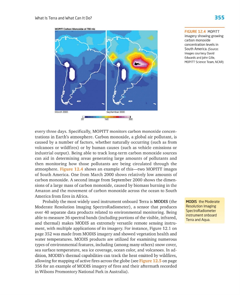
atmosphere. Figure 12.4 shows an example of this—two MOPITT images
of South America. One from March 2000 shows relatively low amounts of
carbon monoxide. A second image from September 2000 shows the dimensions of a large mass of carbon monoxide, caused by biomass burning in the
Amazon and the movement of carbon monoxide across the ocean to South
America from fires in Africa.
Probably the most widely used instrument onboard Terra is MODIS (the
Moderate Resolution Imaging SpectroRadiometer), a sensor that produces
over 40 separate data products related to environmental monitoring. Being
able to measure 36 spectral bands (including portions of the visible, infrared,
and thermal) makes MODIS an extremely versatile remote sensing instrument, with multiple applications of its imagery. For instance, Figure 12.1 on
page 352 was made from MODIS imagery and showed vegetation health and
water temperatures. MODIS products are utilized for examining numerous
types of environmental features, including (among many others) snow cover,
sea surface temperature, sea ice coverage, ocean color, and volcanoes. In addition, MODIS’s thermal capabilities can track the heat emitted by wildfires,
allowing for mapping of active fires across the globe (see Figure 12.5 on page
356 for an example of MODIS imagery of fires and their aftermath recorded
in Wilsons Promontory National Park in Australia).
MODIS the Moderate
Resolution Imaging
SpectroRadiometer
instrument onboard
Terra and Aqua.
FIGURE 12.4 MOPITT
imagery showing growing
carbon monoxide
concentration levels in
South America. (Source:
Images courtesy David
Edwards and John Gille,
MOPITT Science Team, NCAR)
What Is Terra and What Can It Do?
every three days. Specifically, MOPITT monitors carbon monoxide concentrations in Earth’s atmosphere. Carbon monoxide, a global air pollutant, is
caused by a number of factors, whether naturally occurring (such as from
volcanoes or wildfires) or by human causes (such as vehicle emissions or
industrial output). Being able to track long-term carbon monoxide sources
can aid in determining areas generating large amounts of pollutants and
then monitoring how those pollutants are being circulated through the
atmosphere. Figure 12.4 shows an example of this—two MOPITT images
of South America. One from March 2000 shows relatively low amounts of
carbon monoxide. A second image from September 2000 shows the dimensions of a large mass of carbon monoxide, caused by biomass burning in the
Amazon and the movement of carbon monoxide across the ocean to South
America from fires in Africa.
Probably the most widely used instrument onboard Terra is MODIS (the
Moderate Resolution Imaging SpectroRadiometer), a sensor that produces
over 40 separate data products related to environmental monitoring. Being
able to measure 36 spectral bands (including portions of the visible, infrared,
and thermal) makes MODIS an extremely versatile remote sensing instrument, with multiple applications of its imagery. For instance, Figure 12.1 on
page 352 was made from MODIS imagery and showed vegetation health and
water temperatures. MODIS products are utilized for examining numerous
types of environmental features, including (among many others) snow cover,
sea surface temperature, sea ice coverage, ocean color, and volcanoes. In addition, MODIS’s thermal capabilities can track the heat emitted by wildfires,
allowing for mapping of active fires across the globe (see Figure 12.5 on page
356 for an example of MODIS imagery of fires and their aftermath recorded
in Wilsons Promontory National Park in Australia).
MODIS the Moderate
Resolution Imaging
SpectroRadiometer
instrument onboard
Terra and Aqua.
FIGURE 12.4 MOPITT
imagery showing growing
carbon monoxide
concentration levels in
South America. (Source:
Images courtesy David
Edwards and John Gille,
MOPITT Science Team, NCAR)