

329
What Are the Capabilities of a Satellite Sensor?
What Are the Capabilities
of a Satellite Sensor?
A satellite sensor has four characteristics that define its capabilities: spatial
resolution, radiometric resolution, temporal resolution, and spectral resolution. In Chapter 10 we discussed the concept of resolution in the context
of spatial resolution, the area on the ground represented by one pixel in
a satellite image. A sensor’s spatial resolution will affect the amount of detail that can be determined from the imagery. For instance, a sensor with a
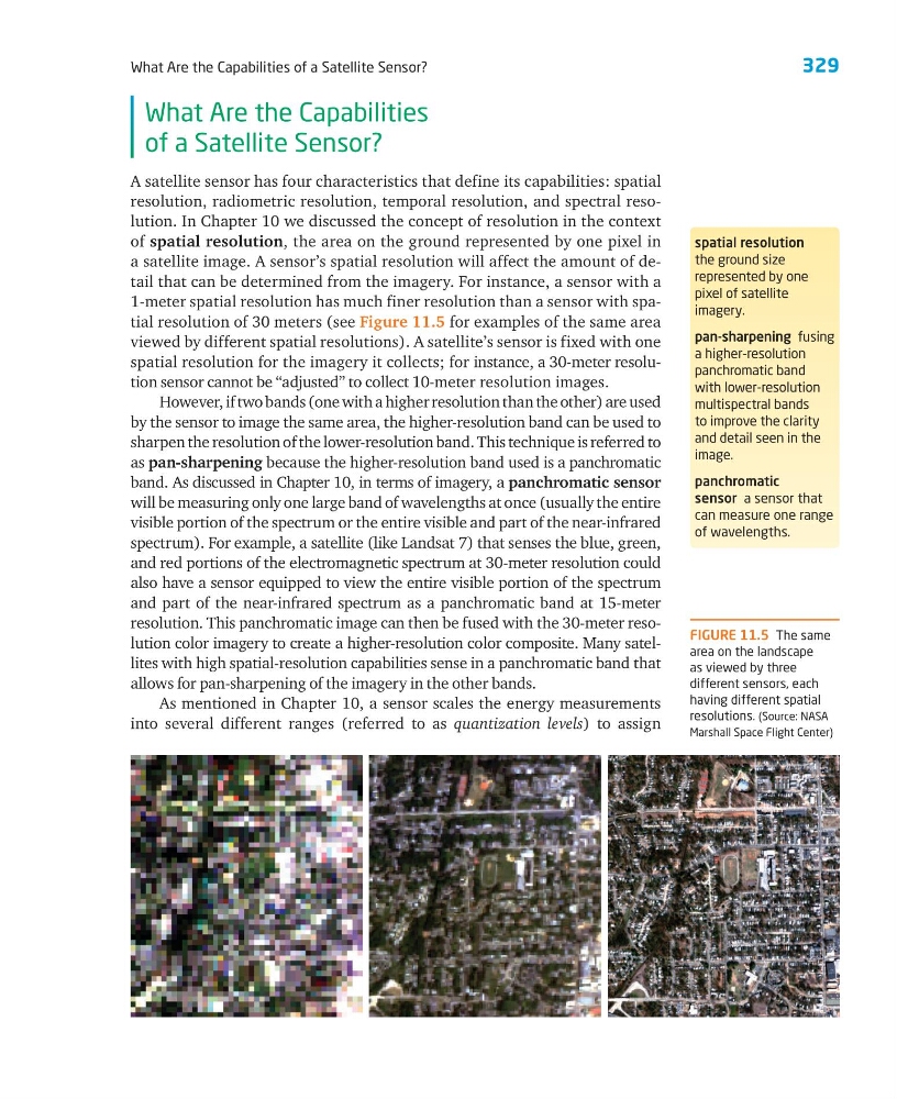
1-meter spatial resolution has much finer resolution than a sensor with spatial resolution of 30 meters (see Figure 11.5 for examples of the same area
viewed by different spatial resolutions). A satellite’s sensor is fixed with one
spatial resolution for the imagery it collects; for instance, a 30-meter resolution sensor cannot be “adjusted” to collect 10-meter resolution images.
However, if two bands (one with a higher resolution than the other) are used
by the sensor to image the same area, the higher-resolution band can be used to
sharpen the resolution of the lower-resolution band. This technique is referred to
as pan-sharpening because the higher-resolution band used is a panchromatic
band. As discussed in Chapter 10, in terms of imagery, a panchromatic sensor
will be measuring only one large band of wavelengths at once (usually the entire
visible portion of the spectrum or the entire visible and part of the near-infrared
spectrum). For example, a satellite (like Landsat 7) that senses the blue, green,
and red portions of the electromagnetic spectrum at 30-meter resolution could
also have a sensor equipped to view the entire visible portion of the spectrum
and part of the near-infrared spectrum as a panchromatic band at 15-meter
resolution. This panchromatic image can then be fused with the 30-meter resolution color imagery to create a higher-resolution color composite. Many satellites with high spatial-resolution capabilities sense in a panchromatic band that
allows for pan-sharpening of the imagery in the other bands.
As mentioned in Chapter 10, a sensor scales the energy measurements
into several different ranges (referred to as quantization levels) to assign
spatial resolution
the ground size
represented by one
pixel of satellite
imagery.
pan-sharpening fusing
a higher-resolution
panchromatic band
with lower-resolution
multispectral bands
to improve the clarity
and detail seen in the
image.
panchromatic
sensor a sensor that
can measure one range
of wavelengths.
FIGURE 11.5 The same
area on the landscape
as viewed by three
different sensors, each
having different spatial
resolutions. (Source: NASA
Marshall Space Flight Center)
What Are the Capabilities of a Satellite Sensor?
What Are the Capabilities
of a Satellite Sensor?
A satellite sensor has four characteristics that define its capabilities: spatial
resolution, radiometric resolution, temporal resolution, and spectral resolution. In Chapter 10 we discussed the concept of resolution in the context
of spatial resolution, the area on the ground represented by one pixel in
a satellite image. A sensor’s spatial resolution will affect the amount of detail that can be determined from the imagery. For instance, a sensor with a
1-meter spatial resolution has much finer resolution than a sensor with spatial resolution of 30 meters (see Figure 11.5 for examples of the same area
viewed by different spatial resolutions). A satellite’s sensor is fixed with one
spatial resolution for the imagery it collects; for instance, a 30-meter resolution sensor cannot be “adjusted” to collect 10-meter resolution images.
However, if two bands (one with a higher resolution than the other) are used
by the sensor to image the same area, the higher-resolution band can be used to
sharpen the resolution of the lower-resolution band. This technique is referred to
as pan-sharpening because the higher-resolution band used is a panchromatic
band. As discussed in Chapter 10, in terms of imagery, a panchromatic sensor
will be measuring only one large band of wavelengths at once (usually the entire
visible portion of the spectrum or the entire visible and part of the near-infrared
spectrum). For example, a satellite (like Landsat 7) that senses the blue, green,
and red portions of the electromagnetic spectrum at 30-meter resolution could
also have a sensor equipped to view the entire visible portion of the spectrum
and part of the near-infrared spectrum as a panchromatic band at 15-meter
resolution. This panchromatic image can then be fused with the 30-meter resolution color imagery to create a higher-resolution color composite. Many satellites with high spatial-resolution capabilities sense in a panchromatic band that
allows for pan-sharpening of the imagery in the other bands.
As mentioned in Chapter 10, a sensor scales the energy measurements
into several different ranges (referred to as quantization levels) to assign
spatial resolution
the ground size
represented by one
pixel of satellite
imagery.
pan-sharpening fusing
a higher-resolution
panchromatic band
with lower-resolution
multispectral bands
to improve the clarity
and detail seen in the
image.
panchromatic
sensor a sensor that
can measure one range
of wavelengths.
FIGURE 11.5 The same
area on the landscape
as viewed by three
different sensors, each
having different spatial
resolutions. (Source: NASA
Marshall Space Flight Center)