

328
Chapter 11 Images from Space
After a satellite’s sensors have collected data, the data needs to be offloaded from the satellite and sent to Earth. Because data collection is continuous, this information needs to get to people on the surface to process it so
it can be utilized. The Earth Resources Observation Science (EROS) Center
located outside Sioux Falls, South Dakota, is one of the downlink stations in
the United States that receives data from numerous remote sensing satellites.
Satellite data can be directly sent to a receiver at a station or transmitted to
other tracking and data relay satellites, which then send the data to Earth.
Once received on the ground, the data can be processed into imagery.
Detector
Rotating
scan mirror
Angular
field of
view
Scan
direction
Scan
direction
Detector array
Ground
resolution
cell
Ground
resolution
cells
(a) Across-track scanner
(b) Along-track scanner
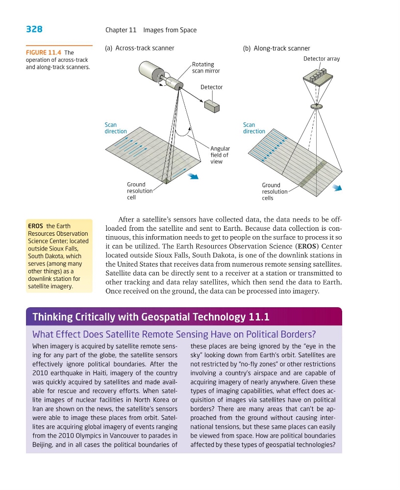
FIGURE 11.4 The
operation of across-track
and along-track scanners.
EROS the Earth
Resources Observation
Science Center; located
outside Sioux Falls,
South Dakota, which
serves (among many
other things) as a
downlink station for
satellite imagery.
When imagery is acquired by satellite remote sensing for any part of the globe, the satellite sensors
effectively ignore political boundaries. After the
2010 earthquake in Haiti, imagery of the country
was quickly acquired by satellites and made available for rescue and recovery efforts. When satellite images of nuclear facilities in North Korea or
Iran are shown on the news, the satellite’s sensors
were able to image these places from orbit. Satellites are acquiring global imagery of events ranging
from the 2010 Olympics in Vancouver to parades in
Beijing, and in all cases the political boundaries of
these places are being ignored by the “eye in the
sky” looking down from Earth’s orbit. Satellites are
not restricted by “no-fly zones” or other restrictions
involving a country’s airspace and are capable of
acquiring imagery of nearly anywhere. Given these
types of imaging capabilities, what effect does acquisition of images via satellites have on political
borders? There are many areas that can’t be approached from the ground without causing international tensions, but these same places can easily
be viewed from space. How are political boundaries
affected by these types of geospatial technologies?
What Effect Does Satellite Remote Sensing Have on Political Borders?
Thinking Critically with Geospatial Technology 11.1
Chapter 11 Images from Space
After a satellite’s sensors have collected data, the data needs to be offloaded from the satellite and sent to Earth. Because data collection is continuous, this information needs to get to people on the surface to process it so
it can be utilized. The Earth Resources Observation Science (EROS) Center
located outside Sioux Falls, South Dakota, is one of the downlink stations in
the United States that receives data from numerous remote sensing satellites.
Satellite data can be directly sent to a receiver at a station or transmitted to
other tracking and data relay satellites, which then send the data to Earth.
Once received on the ground, the data can be processed into imagery.
Detector
Rotating
scan mirror
Angular
field of
view
Scan
direction
Scan
direction
Detector array
Ground
resolution
cell
Ground
resolution
cells
(a) Across-track scanner
(b) Along-track scanner
FIGURE 11.4 The
operation of across-track
and along-track scanners.
EROS the Earth
Resources Observation
Science Center; located
outside Sioux Falls,
South Dakota, which
serves (among many
other things) as a
downlink station for
satellite imagery.
When imagery is acquired by satellite remote sensing for any part of the globe, the satellite sensors
effectively ignore political boundaries. After the
2010 earthquake in Haiti, imagery of the country
was quickly acquired by satellites and made available for rescue and recovery efforts. When satellite images of nuclear facilities in North Korea or
Iran are shown on the news, the satellite’s sensors
were able to image these places from orbit. Satellites are acquiring global imagery of events ranging
from the 2010 Olympics in Vancouver to parades in
Beijing, and in all cases the political boundaries of
these places are being ignored by the “eye in the
sky” looking down from Earth’s orbit. Satellites are
not restricted by “no-fly zones” or other restrictions
involving a country’s airspace and are capable of
acquiring imagery of nearly anywhere. Given these
types of imaging capabilities, what effect does acquisition of images via satellites have on political
borders? There are many areas that can’t be approached from the ground without causing international tensions, but these same places can easily
be viewed from space. How are political boundaries
affected by these types of geospatial technologies?
What Effect Does Satellite Remote Sensing Have on Political Borders?
Thinking Critically with Geospatial Technology 11.1