

231
How Is Address Matching Performed?
middle. However, if the actual real-world location of house number 308 was
closer to the end of the street, then the placement of the plotted point would
not necessarily match up with the actual location of the house. In cases of
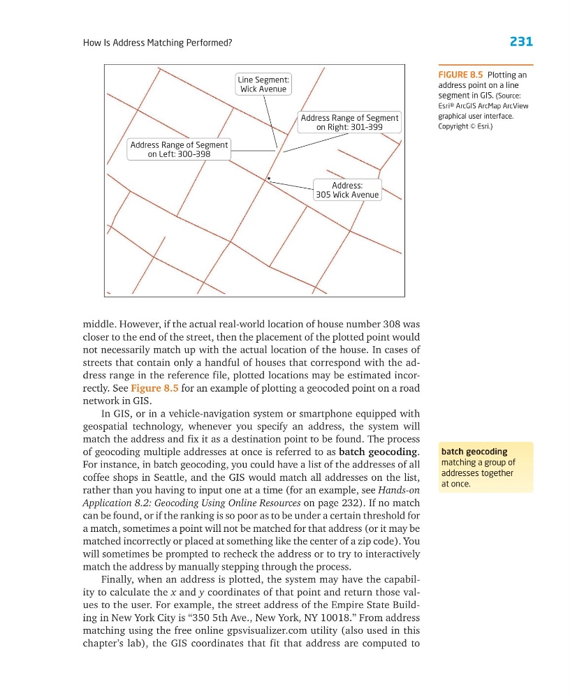
streets that contain only a handful of houses that correspond with the address range in the reference file, plotted locations may be estimated incorrectly. See Figure 8.5 for an example of plotting a geocoded point on a road
network in GIS.
In GIS, or in a vehicle-navigation system or smartphone equipped with
geospatial technology, whenever you specify an address, the system will
match the address and fix it as a destination point to be found. The process
of geocoding multiple addresses at once is referred to as batch geocoding.
For instance, in batch geocoding, you could have a list of the addresses of all
coffee shops in Seattle, and the GIS would match all addresses on the list,
rather than you having to input one at a time (for an example, see Hands-on
Application 8.2: Geocoding Using Online Resources on page 232). If no match
can be found, or if the ranking is so poor as to be under a certain threshold for
a match, sometimes a point will not be matched for that address (or it may be
matched incorrectly or placed at something like the center of a zip code). You
will sometimes be prompted to recheck the address or to try to interactively
match the address by manually stepping through the process.
Finally, when an address is plotted, the system may have the capability to calculate the x and y coordinates of that point and return those values to the user. For example, the street address of the Empire State Building in New York City is “350 5th Ave., New York, NY 10018.” From address
matching using the free online gpsvisualizer.com utility (also used in this
chapter’s lab), the GIS coordinates that fit that address are computed to
batch geocoding
matching a group of
addresses together
at once.
FIGURE 8.5 Plotting an
address point on a line
segment in GIS. (Source:
Esri® ArcGIS ArcMap ArcView
graphical user interface.
Copyright © Esri.)
Address:
305 Wick Avenue
Address Range of Segment
on Right: 301–399
Line Segment:
Wick Avenue
Address Range of Segment
on Left: 300–398
How Is Address Matching Performed?
middle. However, if the actual real-world location of house number 308 was
closer to the end of the street, then the placement of the plotted point would
not necessarily match up with the actual location of the house. In cases of
streets that contain only a handful of houses that correspond with the address range in the reference file, plotted locations may be estimated incorrectly. See Figure 8.5 for an example of plotting a geocoded point on a road
network in GIS.
In GIS, or in a vehicle-navigation system or smartphone equipped with
geospatial technology, whenever you specify an address, the system will
match the address and fix it as a destination point to be found. The process
of geocoding multiple addresses at once is referred to as batch geocoding.
For instance, in batch geocoding, you could have a list of the addresses of all
coffee shops in Seattle, and the GIS would match all addresses on the list,
rather than you having to input one at a time (for an example, see Hands-on
Application 8.2: Geocoding Using Online Resources on page 232). If no match
can be found, or if the ranking is so poor as to be under a certain threshold for
a match, sometimes a point will not be matched for that address (or it may be
matched incorrectly or placed at something like the center of a zip code). You
will sometimes be prompted to recheck the address or to try to interactively
match the address by manually stepping through the process.
Finally, when an address is plotted, the system may have the capability to calculate the x and y coordinates of that point and return those values to the user. For example, the street address of the Empire State Building in New York City is “350 5th Ave., New York, NY 10018.” From address
matching using the free online gpsvisualizer.com utility (also used in this
chapter’s lab), the GIS coordinates that fit that address are computed to
batch geocoding
matching a group of
addresses together
at once.
FIGURE 8.5 Plotting an
address point on a line
segment in GIS. (Source:
Esri® ArcGIS ArcMap ArcView
graphical user interface.
Copyright © Esri.)
Address:
305 Wick Avenue
Address Range of Segment
on Right: 301–399
Line Segment:
Wick Avenue
Address Range of Segment
on Left: 300–398