

232
Chapter 8 Getting There Quicker with Geospatial Technology
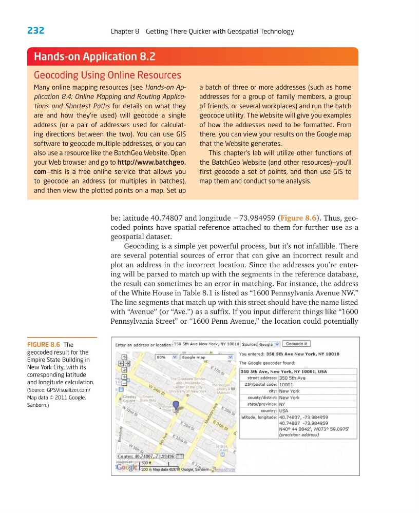
be: latitude 40.74807 and longitude Ϫ73.984959 (Figure 8.6). Thus, geocoded points have spatial reference attached to them for further use as a
geospatial dataset.
Geocoding is a simple yet powerful process, but it’s not infallible. There
are several potential sources of error that can give an incorrect result and
plot an address in the incorrect location. Since the addresses you’re entering will be parsed to match up with the segments in the reference database,
the result can sometimes be an error in matching. For instance, the address
of the White House in Table 8.1 is listed as “1600 Pennsylvania Avenue NW.”
The line segments that match up with this street should have the name listed
with “Avenue” (or “Ave.”) as a suffix. If you input different things like “1600
Pennsylvania Street” or “1600 Penn Avenue,” the location could potentially
Many online mapping resources (see Hands-on Application 8.4: Online Mapping and Routing Applications and Shortest Paths for details on what they
are and how they’re used) will geocode a single
address (or a pair of addresses used for calculating directions between the two). You can use GIS
software to geocode multiple addresses, or you can
also use a resource like the BatchGeo Website. Open
your Web browser and go to http://www.batchgeo.
com—this is a free online service that allows you
to geocode an address (or multiples in batches),
and then view the plotted points on a map. Set up
a batch of three or more addresses (such as home
addresses for a group of family members, a group
of friends, or several workplaces) and run the batch
geocode utility. The Website will give you examples
of how the addresses need to be formatted. From
there, you can view your results on the Google map
that the Website generates.
This chapter’s lab will utilize other functions of
the BatchGeo Website (and other resources)—you’ll
first geocode a set of points, and then use GIS to
map them and conduct some analysis.
Hands-on Application 8.2
Geocoding Using Online Resources
FIGURE 8.6 The
geocoded result for the
Empire State Building in
New York City, with its
corresponding latitude
and longitude calculation.
(Source: GPSVisualizer.com/
Map data © 2011 Google,
Sanborn.)
Chapter 8 Getting There Quicker with Geospatial Technology
be: latitude 40.74807 and longitude Ϫ73.984959 (Figure 8.6). Thus, geocoded points have spatial reference attached to them for further use as a
geospatial dataset.
Geocoding is a simple yet powerful process, but it’s not infallible. There
are several potential sources of error that can give an incorrect result and
plot an address in the incorrect location. Since the addresses you’re entering will be parsed to match up with the segments in the reference database,
the result can sometimes be an error in matching. For instance, the address
of the White House in Table 8.1 is listed as “1600 Pennsylvania Avenue NW.”
The line segments that match up with this street should have the name listed
with “Avenue” (or “Ave.”) as a suffix. If you input different things like “1600
Pennsylvania Street” or “1600 Penn Avenue,” the location could potentially
Many online mapping resources (see Hands-on Application 8.4: Online Mapping and Routing Applications and Shortest Paths for details on what they
are and how they’re used) will geocode a single
address (or a pair of addresses used for calculating directions between the two). You can use GIS
software to geocode multiple addresses, or you can
also use a resource like the BatchGeo Website. Open
your Web browser and go to http://www.batchgeo.
com—this is a free online service that allows you
to geocode an address (or multiples in batches),
and then view the plotted points on a map. Set up
a batch of three or more addresses (such as home
addresses for a group of family members, a group
of friends, or several workplaces) and run the batch
geocode utility. The Website will give you examples
of how the addresses need to be formatted. From
there, you can view your results on the Google map
that the Website generates.
This chapter’s lab will utilize other functions of
the BatchGeo Website (and other resources)—you’ll
first geocode a set of points, and then use GIS to
map them and conduct some analysis.
Hands-on Application 8.2
Geocoding Using Online Resources
FIGURE 8.6 The
geocoded result for the
Empire State Building in
New York City, with its
corresponding latitude
and longitude calculation.
(Source: GPSVisualizer.com/
Map data © 2011 Google,
Sanborn.)