

190
Chapter 7 Using GIS to Make a Map
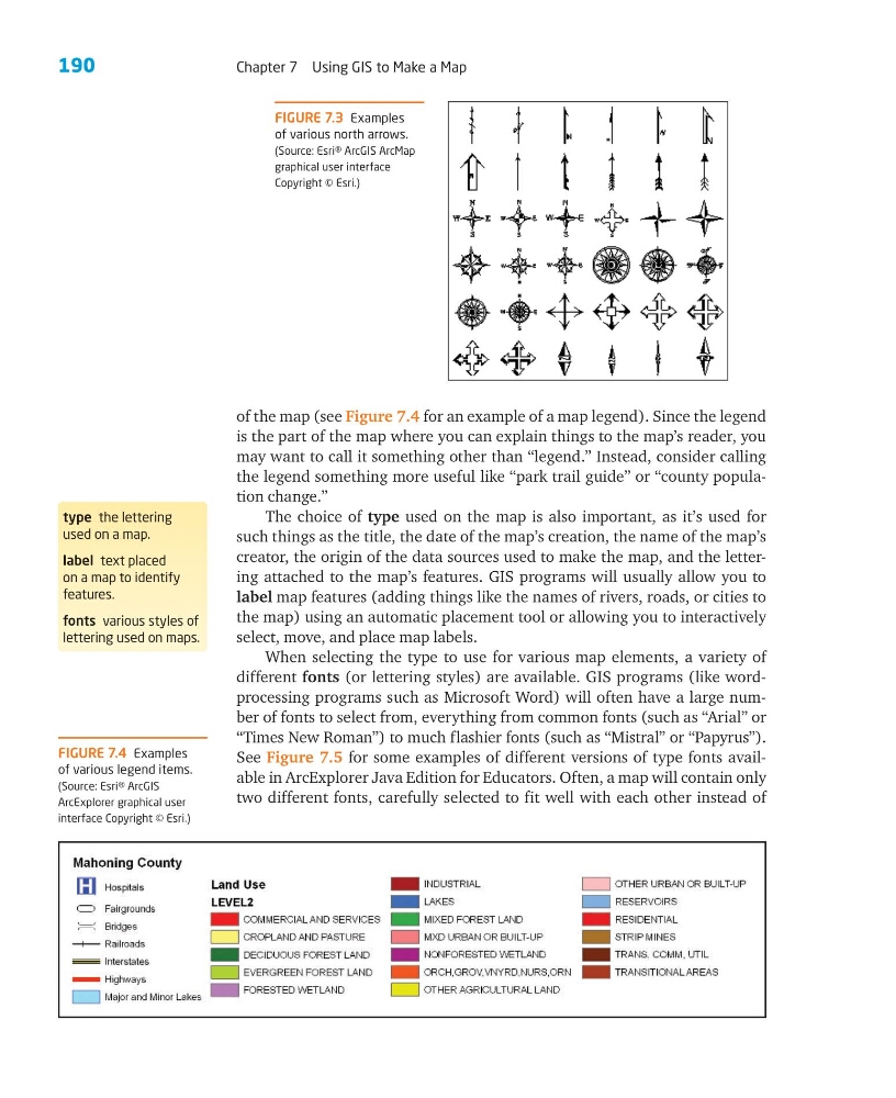
FIGURE 7.3 Examples
of various north arrows.
(Source: Esri® ArcGIS ArcMap
graphical user interface
Copyright © Esri.)
of the map (see Figure 7.4 for an example of a map legend). Since the legend
is the part of the map where you can explain things to the map’s reader, you
may want to call it something other than “legend.” Instead, consider calling
the legend something more useful like “park trail guide” or “county population change.”
The choice of type used on the map is also important, as it’s used for
such things as the title, the date of the map’s creation, the name of the map’s
creator, the origin of the data sources used to make the map, and the lettering attached to the map’s features. GIS programs will usually allow you to
label map features (adding things like the names of rivers, roads, or cities to
the map) using an automatic placement tool or allowing you to interactively
select, move, and place map labels.
When selecting the type to use for various map elements, a variety of
different fonts (or lettering styles) are available. GIS programs (like wordprocessing programs such as Microsoft Word) will often have a large number of fonts to select from, everything from common fonts (such as “Arial” or
“Times New Roman”) to much flashier fonts (such as “Mistral” or “Papyrus”).
See Figure 7.5 for some examples of different versions of type fonts available in ArcExplorer Java Edition for Educators. Often, a map will contain only
two different fonts, carefully selected to fit well with each other instead of
FIGURE 7.4 Examples
of various legend items.
(Source: Esri® ArcGIS
ArcExplorer graphical user
interface Copyright © Esri.)
type the lettering
used on a map.
label text placed
on a map to identify
features.
fonts various styles of
lettering used on maps.
Chapter 7 Using GIS to Make a Map
FIGURE 7.3 Examples
of various north arrows.
(Source: Esri® ArcGIS ArcMap
graphical user interface
Copyright © Esri.)
of the map (see Figure 7.4 for an example of a map legend). Since the legend
is the part of the map where you can explain things to the map’s reader, you
may want to call it something other than “legend.” Instead, consider calling
the legend something more useful like “park trail guide” or “county population change.”
The choice of type used on the map is also important, as it’s used for
such things as the title, the date of the map’s creation, the name of the map’s
creator, the origin of the data sources used to make the map, and the lettering attached to the map’s features. GIS programs will usually allow you to
label map features (adding things like the names of rivers, roads, or cities to
the map) using an automatic placement tool or allowing you to interactively
select, move, and place map labels.
When selecting the type to use for various map elements, a variety of
different fonts (or lettering styles) are available. GIS programs (like wordprocessing programs such as Microsoft Word) will often have a large number of fonts to select from, everything from common fonts (such as “Arial” or
“Times New Roman”) to much flashier fonts (such as “Mistral” or “Papyrus”).
See Figure 7.5 for some examples of different versions of type fonts available in ArcExplorer Java Edition for Educators. Often, a map will contain only
two different fonts, carefully selected to fit well with each other instead of
FIGURE 7.4 Examples
of various legend items.
(Source: Esri® ArcGIS
ArcExplorer graphical user
interface Copyright © Esri.)
type the lettering
used on a map.
label text placed
on a map to identify
features.
fonts various styles of
lettering used on maps.