

168
Chapter 6 Using GIS for Spatial Analysis
2. All of the currently selected points will no longer be selected.
3. For this section, you’ll be creating buffers around line features and
examining the spatial relations of other objects to these lines.
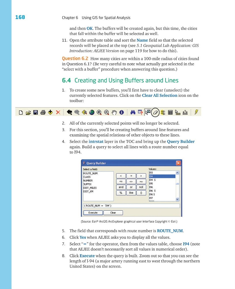
4. Select the intrstat layer in the TOC and bring up the Query Builder
again. Build a query to select all lines with a route number equal
to I94.
(Source: Esri® ArcGIS ArcExplorer graphical user interface Copyright © Esri.)
5. The field that corresponds with route number is ROUTE_NUM.
6. Click Yes when AEJEE asks you to display all the values.
7. Select ‘‘=’’ for the operator, then from the values table, choose I94 (note
that AEJEE doesn’t necessarily sort all values in numerical order).
8. Click Execute when the query is built. Zoom out so that you can see the
length of I-94 (a major artery running east to west through the northern
United States) on the screen.
and then OK. The buffers will be created again, but this time, the cities
that fall within the buffer will be selected as well.
11. Open the attribute table and sort the Name field so that the selected
records will be placed at the top (see 5.1 Geospatial Lab Application: GIS
Introduction: AEJEE Version on page 119 for how to do this).
Question 6.2 How many cities are within a 100-mile radius of cities found
in Question 6.1? (Be very careful to note what actually got selected in the
“select with a buffer” procedure when answering this question.)
6.4 Creating and Using Buffers around Lines
1. To create some new buffers, you’ll first have to clear (unselect) the
currently selected features. Click on the Clear All Selection icon on the
toolbar:
Chapter 6 Using GIS for Spatial Analysis
2. All of the currently selected points will no longer be selected.
3. For this section, you’ll be creating buffers around line features and
examining the spatial relations of other objects to these lines.
4. Select the intrstat layer in the TOC and bring up the Query Builder
again. Build a query to select all lines with a route number equal
to I94.
(Source: Esri® ArcGIS ArcExplorer graphical user interface Copyright © Esri.)
5. The field that corresponds with route number is ROUTE_NUM.
6. Click Yes when AEJEE asks you to display all the values.
7. Select ‘‘=’’ for the operator, then from the values table, choose I94 (note
that AEJEE doesn’t necessarily sort all values in numerical order).
8. Click Execute when the query is built. Zoom out so that you can see the
length of I-94 (a major artery running east to west through the northern
United States) on the screen.
and then OK. The buffers will be created again, but this time, the cities
that fall within the buffer will be selected as well.
11. Open the attribute table and sort the Name field so that the selected
records will be placed at the top (see 5.1 Geospatial Lab Application: GIS
Introduction: AEJEE Version on page 119 for how to do this).
Question 6.2 How many cities are within a 100-mile radius of cities found
in Question 6.1? (Be very careful to note what actually got selected in the
“select with a buffer” procedure when answering this question.)
6.4 Creating and Using Buffers around Lines
1. To create some new buffers, you’ll first have to clear (unselect) the
currently selected features. Click on the Clear All Selection icon on the
toolbar: