

167
GIS Spatial Analysis: AEJEE Version
(Source: Esri® ArcGIS ArcExplorer graphical user interface Copyright © Esri.)
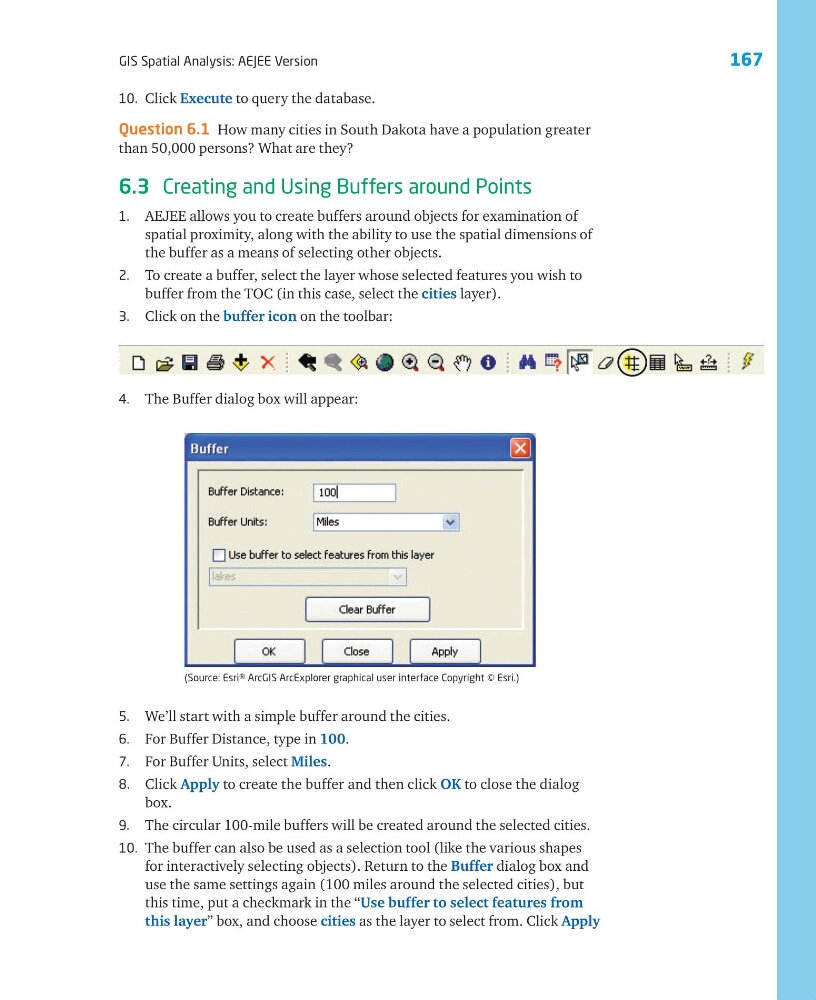
4. The Buffer dialog box will appear:
5. We’ll start with a simple buffer around the cities.
6. For Buffer Distance, type in 100.
7. For Buffer Units, select Miles.
8. Click Apply to create the buffer and then click OK to close the dialog
box.
9. The circular 100-mile buffers will be created around the selected cities.
10. The buffer can also be used as a selection tool (like the various shapes
for interactively selecting objects). Return to the Buffer dialog box and
use the same settings again (100 miles around the selected cities), but
this time, put a checkmark in the “Use buffer to select features from
this layer” box, and choose cities as the layer to select from. Click Apply
10. Click Execute to query the database.
Question 6.1 How many cities in South Dakota have a population greater
than 50,000 persons? What are they?
6.3 Creating and Using Buffers around Points
1. AEJEE allows you to create buffers around objects for examination of
spatial proximity, along with the ability to use the spatial dimensions of
the buffer as a means of selecting other objects.
2. To create a buffer, select the layer whose selected features you wish to
buffer from the TOC (in this case, select the cities layer).
3. Click on the buffer icon on the toolbar:
GIS Spatial Analysis: AEJEE Version
(Source: Esri® ArcGIS ArcExplorer graphical user interface Copyright © Esri.)
4. The Buffer dialog box will appear:
5. We’ll start with a simple buffer around the cities.
6. For Buffer Distance, type in 100.
7. For Buffer Units, select Miles.
8. Click Apply to create the buffer and then click OK to close the dialog
box.
9. The circular 100-mile buffers will be created around the selected cities.
10. The buffer can also be used as a selection tool (like the various shapes
for interactively selecting objects). Return to the Buffer dialog box and
use the same settings again (100 miles around the selected cities), but
this time, put a checkmark in the “Use buffer to select features from
this layer” box, and choose cities as the layer to select from. Click Apply
10. Click Execute to query the database.
Question 6.1 How many cities in South Dakota have a population greater
than 50,000 persons? What are they?
6.3 Creating and Using Buffers around Points
1. AEJEE allows you to create buffers around objects for examination of
spatial proximity, along with the ability to use the spatial dimensions of
the buffer as a means of selecting other objects.
2. To create a buffer, select the layer whose selected features you wish to
buffer from the TOC (in this case, select the cities layer).
3. Click on the buffer icon on the toolbar: