

161
How Can Multiple Types of Spatial Analysis Operations Be Performed in GIS?
of this would be to try and determine which parcels of land surrounding Civil
War battlefields are under the greatest pressure to convert to an urban land
use. Battlefield land is often considered a historic monument to the men who
died during the Civil War, and while the core areas of several sites are under
the protection of the U. S. National Park Service, there are many other sites that
have been developed over or are in danger of having residential or commercial
properties built on them, forever losing the “hallowed ground” of history.
GIS can be used to combine a number of factors together that influence
where new developments could be occurring (such as proximity to big cities,
existing urban areas, or water bodies) similar to Site Suitability to try and find
the areas under the greatest development pressures. This type of information
could be used by preservationists when attempting to purchase lands to keep
them undeveloped.
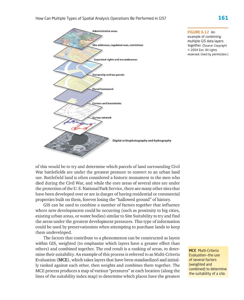
The factors that contribute to a phenomenon can be constructed as layers
within GIS, weighted (to emphasize which layers have a greater effect than
others) and combined together. The end result is a ranking of areas, to determine their suitability. An example of this process is referred to as Multi-Criteria
Evaluation (MCE), which takes layers that have been standardized and initially ranked against each other, then weights and combines them together. The
MCE process produces a map of various “pressures” at each location (along the
lines of the suitability index map) to determine which places have the greatest
MCE Multi-Criteria
Evaluation—the use
of several factors
(weighted and
combined) to determine
the suitability of a site.
FIGURE 6.12 An
example of combining
multiple GIS data layers
together. (Source: Copyright
© 2004 Esri. All rights
reserved. Used by permission.)
How Can Multiple Types of Spatial Analysis Operations Be Performed in GIS?
of this would be to try and determine which parcels of land surrounding Civil
War battlefields are under the greatest pressure to convert to an urban land
use. Battlefield land is often considered a historic monument to the men who
died during the Civil War, and while the core areas of several sites are under
the protection of the U. S. National Park Service, there are many other sites that
have been developed over or are in danger of having residential or commercial
properties built on them, forever losing the “hallowed ground” of history.
GIS can be used to combine a number of factors together that influence
where new developments could be occurring (such as proximity to big cities,
existing urban areas, or water bodies) similar to Site Suitability to try and find
the areas under the greatest development pressures. This type of information
could be used by preservationists when attempting to purchase lands to keep
them undeveloped.
The factors that contribute to a phenomenon can be constructed as layers
within GIS, weighted (to emphasize which layers have a greater effect than
others) and combined together. The end result is a ranking of areas, to determine their suitability. An example of this process is referred to as Multi-Criteria
Evaluation (MCE), which takes layers that have been standardized and initially ranked against each other, then weights and combines them together. The
MCE process produces a map of various “pressures” at each location (along the
lines of the suitability index map) to determine which places have the greatest
MCE Multi-Criteria
Evaluation—the use
of several factors
(weighted and
combined) to determine
the suitability of a site.
FIGURE 6.12 An
example of combining
multiple GIS data layers
together. (Source: Copyright
© 2004 Esri. All rights
reserved. Used by permission.)