

162
Chapter 6 Using GIS for Spatial Analysis
influence placed on them (based on the combination of all the input layers).
This acts like a more complex form of the basic site suitability and can be used
in decision making processes to help something like determining which pieces
of battlefield land have the greatest development pressures on them to convert
to an urban land use. Other problems, such as locating suitable animal habitats, areas of high flood potential, or places for retail sites can be approached
using similar types of techniques.
A different example of a GIS Model is the Land Transformation Model
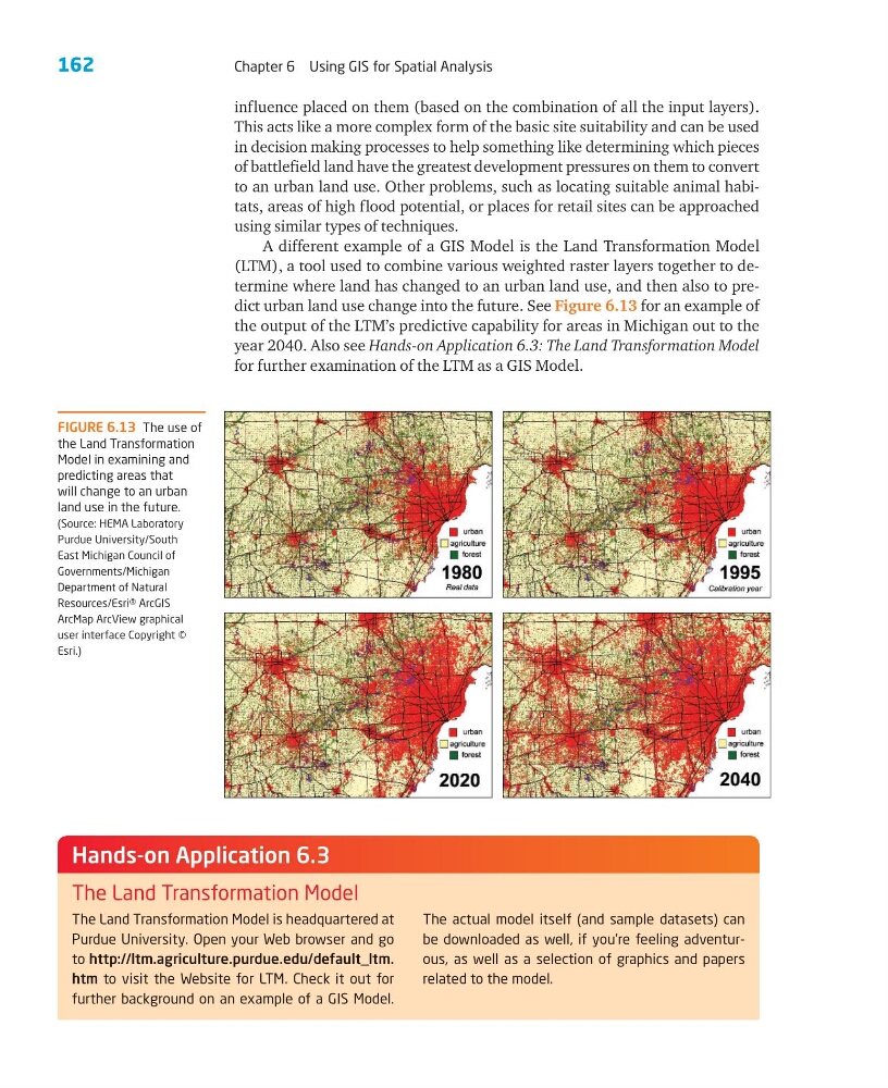
(LTM), a tool used to combine various weighted raster layers together to determine where land has changed to an urban land use, and then also to predict urban land use change into the future. See Figure 6.13 for an example of
the output of the LTM’s predictive capability for areas in Michigan out to the
year 2040. Also see Hands-on Application 6.3: The Land Transformation Model
for further examination of the LTM as a GIS Model.
FIGURE 6.13 The use of
the Land Transformation
Model in examining and
predicting areas that
will change to an urban
land use in the future.
(Source: HEMA Laboratory
Purdue University/South
East Michigan Council of
Governments/Michigan
Department of Natural
Resources/Esri® ArcGIS
ArcMap ArcView graphical
user interface Copyright ©
Esri.)
The Land Transformation Model is headquartered at
Purdue University. Open your Web browser and go
to http://ltm.agriculture.purdue.edu/default_ltm.
htm to visit the Website for LTM. Check it out for
further background on an example of a GIS Model.
The actual model itself (and sample datasets) can
be downloaded as well, if you’re feeling adventurous, as well as a selection of graphics and papers
related to the model.
Hands-on Application 6.3
The Land Transformation Model
Chapter 6 Using GIS for Spatial Analysis
influence placed on them (based on the combination of all the input layers).
This acts like a more complex form of the basic site suitability and can be used
in decision making processes to help something like determining which pieces
of battlefield land have the greatest development pressures on them to convert
to an urban land use. Other problems, such as locating suitable animal habitats, areas of high flood potential, or places for retail sites can be approached
using similar types of techniques.
A different example of a GIS Model is the Land Transformation Model
(LTM), a tool used to combine various weighted raster layers together to determine where land has changed to an urban land use, and then also to predict urban land use change into the future. See Figure 6.13 for an example of
the output of the LTM’s predictive capability for areas in Michigan out to the
year 2040. Also see Hands-on Application 6.3: The Land Transformation Model
for further examination of the LTM as a GIS Model.
FIGURE 6.13 The use of
the Land Transformation
Model in examining and
predicting areas that
will change to an urban
land use in the future.
(Source: HEMA Laboratory
Purdue University/South
East Michigan Council of
Governments/Michigan
Department of Natural
Resources/Esri® ArcGIS
ArcMap ArcView graphical
user interface Copyright ©
Esri.)
The Land Transformation Model is headquartered at
Purdue University. Open your Web browser and go
to http://ltm.agriculture.purdue.edu/default_ltm.
htm to visit the Website for LTM. Check it out for
further background on an example of a GIS Model.
The actual model itself (and sample datasets) can
be downloaded as well, if you’re feeling adventurous, as well as a selection of graphics and papers
related to the model.
Hands-on Application 6.3
The Land Transformation Model