

158
Chapter 6 Using GIS for Spatial Analysis
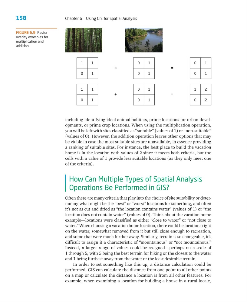
including identifying ideal animal habitats, prime locations for urban developments, or prime crop locations. When using the multiplication operation,
you will be left with sites classified as “suitable” (values of 1) or “non-suitable”
(values of 0). However, the addition operation leaves other options that may
be viable in case the most suitable sites are unavailable, in essence providing
a ranking of suitable sites. For instance, the best place to build the vacation
home is in the location with values of 2 since it meets both criteria, but the
cells with a value of 1 provide less suitable locations (as they only meet one
of the criteria).
How Can Multiple Types of Spatial Analysis
Operations Be Performed in GIS?
Often there are many criteria that play into the choice of site suitability or determining what might be the “best” or “worst” locations for something, and often
it’s not as cut and dried as “the location contains water” (values of 1) or “the
location does not contain water” (values of 0). Think about the vacation home
example—locations were classified as either “close to water” or “not close to
water.” When choosing a vacation home location, there could be locations right
on the water, somewhat removed from it but still close enough to recreation,
and some that were much further away. Similarly, terrain is so changeable, it’s
difficult to assign it a characteristic of “mountainous” or “not mountainous.”
Instead, a larger range of values could be assigned—perhaps on a scale of
1 through 5, with 5 being the best terrain for hiking or the closest to the water
and 1 being furthest away from the water or the least desirable terrain.
In order to set something like this up, a distance calculation could be
performed. GIS can calculate the distance from one point to all other points
on a map or calculate the distance a location is from all other features. For
example, when examining a location for building a house in a rural locale,
1
1
0
1
×
0
1
0
1
=
0
1
0
1
1
1
0
1
+
0
1
0
1
=
1
2
0
2
FIGURE 6.9 Raster
overlay examples for
multiplication and
addition.
Chapter 6 Using GIS for Spatial Analysis
including identifying ideal animal habitats, prime locations for urban developments, or prime crop locations. When using the multiplication operation,
you will be left with sites classified as “suitable” (values of 1) or “non-suitable”
(values of 0). However, the addition operation leaves other options that may
be viable in case the most suitable sites are unavailable, in essence providing
a ranking of suitable sites. For instance, the best place to build the vacation
home is in the location with values of 2 since it meets both criteria, but the
cells with a value of 1 provide less suitable locations (as they only meet one
of the criteria).
How Can Multiple Types of Spatial Analysis
Operations Be Performed in GIS?
Often there are many criteria that play into the choice of site suitability or determining what might be the “best” or “worst” locations for something, and often
it’s not as cut and dried as “the location contains water” (values of 1) or “the
location does not contain water” (values of 0). Think about the vacation home
example—locations were classified as either “close to water” or “not close to
water.” When choosing a vacation home location, there could be locations right
on the water, somewhat removed from it but still close enough to recreation,
and some that were much further away. Similarly, terrain is so changeable, it’s
difficult to assign it a characteristic of “mountainous” or “not mountainous.”
Instead, a larger range of values could be assigned—perhaps on a scale of
1 through 5, with 5 being the best terrain for hiking or the closest to the water
and 1 being furthest away from the water or the least desirable terrain.
In order to set something like this up, a distance calculation could be
performed. GIS can calculate the distance from one point to all other points
on a map or calculate the distance a location is from all other features. For
example, when examining a location for building a house in a rural locale,
1
1
0
1
×
0
1
0
1
=
0
1
0
1
1
1
0
1
+
0
1
0
1
=
1
2
0
2
FIGURE 6.9 Raster
overlay examples for
multiplication and
addition.