

156
Chapter 6 Using GIS for Spatial Analysis
operation could show you, for example, all potential nesting areas along
with the local plan for development, except where they overlap (so those
areas can be taken out of the analysis).
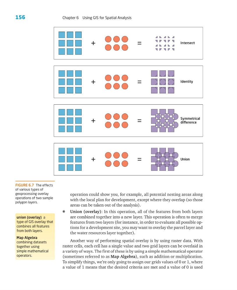
a Union (overlay): In this operation, all of the features from both layers
are combined together into a new layer. This operation is often to merge
features from two layers (for instance, in order to evaluate all possible options for a development site, you may want to overlay the parcel layer and
the water resources layer together).
Another way of performing spatial overlay is by using raster data. With
raster cells, each cell has a single value and two grid layers can be overlaid in
a variety of ways. The first of these is by using a simple mathematical operator
(sometimes referred to as Map Algebra), such as addition or multiplication.
To simplify things, we’re only going to assign our grids values of 0 or 1, where
a value of 1 means that the desired criteria are met and a value of 0 is used
FIGURE 6.7 The effects
of various types of
geoprocessing overlay
operations of two sample
polygon layers.
union (overlay) a
type of GIS overlay that
combines all features
from both layers.
Map Algebra
combining datasets
together using
simple mathematical
operators.
+=
Intersect
Identity
Symmetrical
diference
Union
=
+
+=
+=
Chapter 6 Using GIS for Spatial Analysis
operation could show you, for example, all potential nesting areas along
with the local plan for development, except where they overlap (so those
areas can be taken out of the analysis).
a Union (overlay): In this operation, all of the features from both layers
are combined together into a new layer. This operation is often to merge
features from two layers (for instance, in order to evaluate all possible options for a development site, you may want to overlay the parcel layer and
the water resources layer together).
Another way of performing spatial overlay is by using raster data. With
raster cells, each cell has a single value and two grid layers can be overlaid in
a variety of ways. The first of these is by using a simple mathematical operator
(sometimes referred to as Map Algebra), such as addition or multiplication.
To simplify things, we’re only going to assign our grids values of 0 or 1, where
a value of 1 means that the desired criteria are met and a value of 0 is used
FIGURE 6.7 The effects
of various types of
geoprocessing overlay
operations of two sample
polygon layers.
union (overlay) a
type of GIS overlay that
combines all features
from both layers.
Map Algebra
combining datasets
together using
simple mathematical
operators.
+=
Intersect
Identity
Symmetrical
diference
Union
=
+
+=
+=