

154
Chapter 6 Using GIS for Spatial Analysis
things like how many registered sex offenders reside within a certain distance away from a school or which hospitals are within a particular distance
of your home. The same kind of query would be done if a researcher wanted
to determine which cholera deaths are within a buffer zone around a well.
In these cases, the spatial dimensions of the buffer are being used as the
selection criteria—all objects within the buffer are what will be selected.
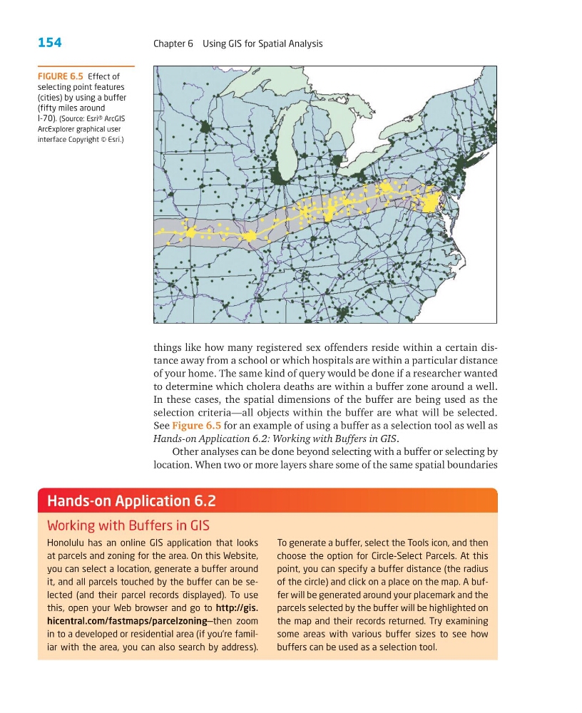
See Figure 6.5 for an example of using a buffer as a selection tool as well as
Hands-on Application 6.2: Working with Buffers in GIS.
Other analyses can be done beyond selecting with a buffer or selecting by
location. When two or more layers share some of the same spatial boundaries
FIGURE 6.5 Effect of
selecting point features
(cities) by using a buffer
(fifty miles around
I-70). (Source: Esri® ArcGIS
ArcExplorer graphical user
interface Copyright © Esri.)
Honolulu has an online GIS application that looks
at parcels and zoning for the area. On this Website,
you can select a location, generate a buffer around
it, and all parcels touched by the buffer can be selected (and their parcel records displayed). To use
this, open your Web browser and go to http://gis.
hicentral.com/fastmaps/parcelzoning—then zoom
in to a developed or residential area (if you’re familiar with the area, you can also search by address).
To generate a buffer, select the Tools icon, and then
choose the option for Circle-Select Parcels. At this
point, you can specify a buffer distance (the radius
of the circle) and click on a place on the map. A buffer will be generated around your placemark and the
parcels selected by the buffer will be highlighted on
the map and their records returned. Try examining
some areas with various buffer sizes to see how
buffers can be used as a selection tool.
Hands-on Application 6.2
Working with Buffers in GIS
Chapter 6 Using GIS for Spatial Analysis
things like how many registered sex offenders reside within a certain distance away from a school or which hospitals are within a particular distance
of your home. The same kind of query would be done if a researcher wanted
to determine which cholera deaths are within a buffer zone around a well.
In these cases, the spatial dimensions of the buffer are being used as the
selection criteria—all objects within the buffer are what will be selected.
See Figure 6.5 for an example of using a buffer as a selection tool as well as
Hands-on Application 6.2: Working with Buffers in GIS.
Other analyses can be done beyond selecting with a buffer or selecting by
location. When two or more layers share some of the same spatial boundaries
FIGURE 6.5 Effect of
selecting point features
(cities) by using a buffer
(fifty miles around
I-70). (Source: Esri® ArcGIS
ArcExplorer graphical user
interface Copyright © Esri.)
Honolulu has an online GIS application that looks
at parcels and zoning for the area. On this Website,
you can select a location, generate a buffer around
it, and all parcels touched by the buffer can be selected (and their parcel records displayed). To use
this, open your Web browser and go to http://gis.
hicentral.com/fastmaps/parcelzoning—then zoom
in to a developed or residential area (if you’re familiar with the area, you can also search by address).
To generate a buffer, select the Tools icon, and then
choose the option for Circle-Select Parcels. At this
point, you can specify a buffer distance (the radius
of the circle) and click on a place on the map. A buffer will be generated around your placemark and the
parcels selected by the buffer will be highlighted on
the map and their records returned. Try examining
some areas with various buffer sizes to see how
buffers can be used as a selection tool.
Hands-on Application 6.2
Working with Buffers in GIS