

142
Chapter 5 Working With Digital Spatial Data and GIS
a lot of digging through the data. However, ArcMap has some helpful
sorting features, including one that will sort the table and only show the
selected records.
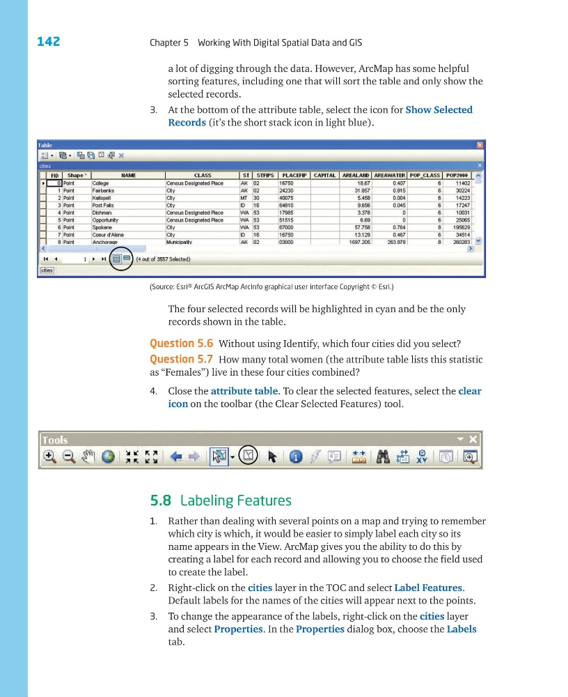
3. At the bottom of the attribute table, select the icon for Show Selected
Records (it’s the short stack icon in light blue).
The four selected records will be highlighted in cyan and be the only
records shown in the table.
Question 5.6 Without using Identify, which four cities did you select?
Question 5.7 How many total women (the attribute table lists this statistic
as “Females”) live in these four cities combined?
4. Close the attribute table. To clear the selected features, select the clear
icon on the toolbar (the Clear Selected Features) tool.
5.8 Labeling Features
1. Rather than dealing with several points on a map and trying to remember
which city is which, it would be easier to simply label each city so its
name appears in the View. ArcMap gives you the ability to do this by
creating a label for each record and allowing you to choose the field used
to create the label.
2. Right-click on the cities layer in the TOC and select Label Features.
Default labels for the names of the cities will appear next to the points.
3. To change the appearance of the labels, right-click on the cities layer
and select Properties. In the Properties dialog box, choose the Labels
tab.
(Source: Esri® ArcGIS ArcMap ArcInfo graphical user interface Copyright © Esri.)
Chapter 5 Working With Digital Spatial Data and GIS
a lot of digging through the data. However, ArcMap has some helpful
sorting features, including one that will sort the table and only show the
selected records.
3. At the bottom of the attribute table, select the icon for Show Selected
Records (it’s the short stack icon in light blue).
The four selected records will be highlighted in cyan and be the only
records shown in the table.
Question 5.6 Without using Identify, which four cities did you select?
Question 5.7 How many total women (the attribute table lists this statistic
as “Females”) live in these four cities combined?
4. Close the attribute table. To clear the selected features, select the clear
icon on the toolbar (the Clear Selected Features) tool.
5.8 Labeling Features
1. Rather than dealing with several points on a map and trying to remember
which city is which, it would be easier to simply label each city so its
name appears in the View. ArcMap gives you the ability to do this by
creating a label for each record and allowing you to choose the field used
to create the label.
2. Right-click on the cities layer in the TOC and select Label Features.
Default labels for the names of the cities will appear next to the points.
3. To change the appearance of the labels, right-click on the cities layer
and select Properties. In the Properties dialog box, choose the Labels
tab.
(Source: Esri® ArcGIS ArcMap ArcInfo graphical user interface Copyright © Esri.)