

140
Chapter 5 Working With Digital Spatial Data and GIS
3. Choose Cities for the Layers to look In.
4. Select the option for All fields for the Search.
5. Click the Find button. The returned results will be shown in the bottom
of the dialog box.
6. Drag the dialog box out of the way so you can see both it and the View at
the same time.
7. Double-click on the result for Akron in the bottom of the dialog box.
8. You’ll see that the point symbol for the city of Akron briefly highlights
and changes color.
9. Right-click on the same results in the Find dialog box and choose Select
from the available options. You’ll see that the point representing Akron
has changed color to a light blue. This means it has been “selected”
by ArcMap—any actions performed on the cities layer will affect the
selected items, not all of the cities.
10. However, all that Find does is locate and select an object. To obtain
information about it, you can use the Identify tool (the icon on the
toolbar is the white “i” in a purple circle).
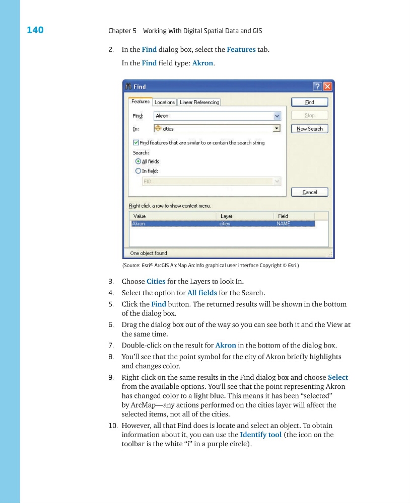
(Source: Esri® ArcGIS ArcMap ArcInfo graphical user interface Copyright © Esri.)
2. In the Find dialog box, select the Features tab.
In the Find field type: Akron.
Chapter 5 Working With Digital Spatial Data and GIS
3. Choose Cities for the Layers to look In.
4. Select the option for All fields for the Search.
5. Click the Find button. The returned results will be shown in the bottom
of the dialog box.
6. Drag the dialog box out of the way so you can see both it and the View at
the same time.
7. Double-click on the result for Akron in the bottom of the dialog box.
8. You’ll see that the point symbol for the city of Akron briefly highlights
and changes color.
9. Right-click on the same results in the Find dialog box and choose Select
from the available options. You’ll see that the point representing Akron
has changed color to a light blue. This means it has been “selected”
by ArcMap—any actions performed on the cities layer will affect the
selected items, not all of the cities.
10. However, all that Find does is locate and select an object. To obtain
information about it, you can use the Identify tool (the icon on the
toolbar is the white “i” in a purple circle).
(Source: Esri® ArcGIS ArcMap ArcInfo graphical user interface Copyright © Esri.)
2. In the Find dialog box, select the Features tab.
In the Find field type: Akron.