

133
GIS Introduction: ArcGIS Version
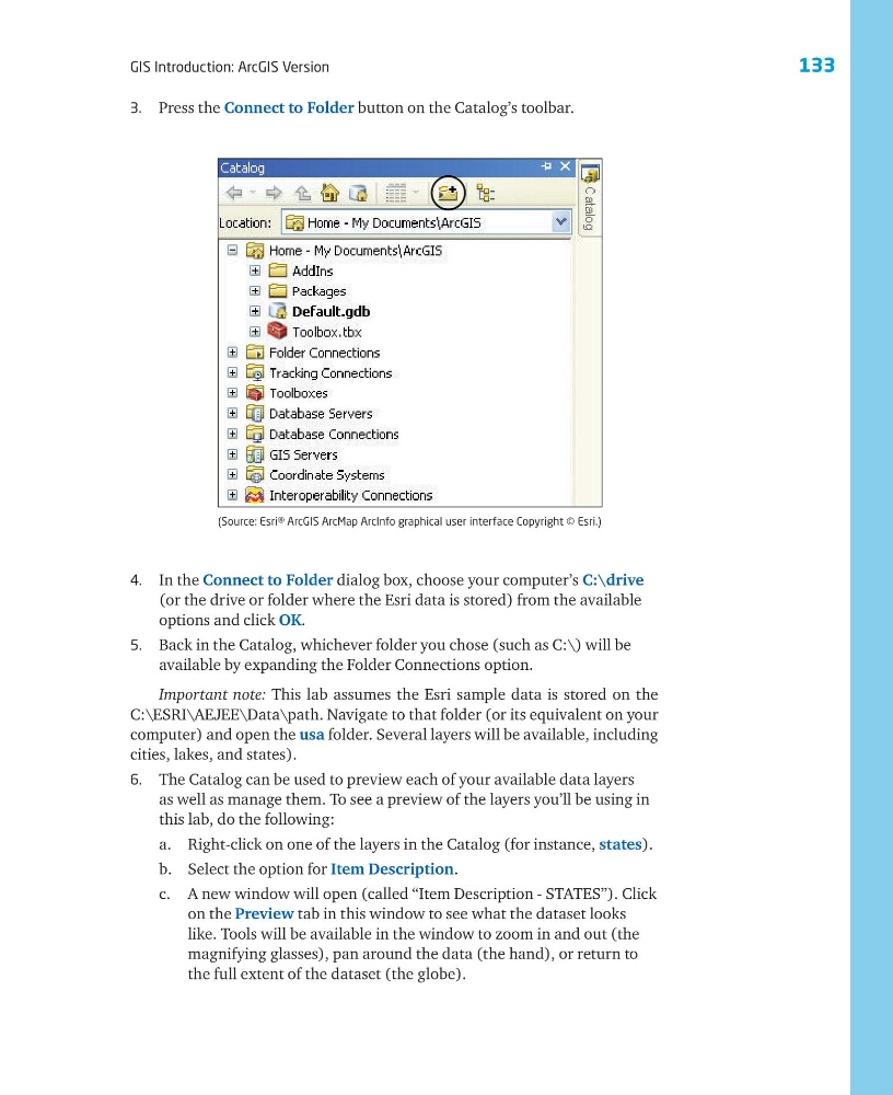
3. Press the Connect to Folder button on the Catalog’s toolbar.
4. In the Connect to Folder dialog box, choose your computer’s C:\drive
(or the drive or folder where the Esri data is stored) from the available
options and click OK.
5. Back in the Catalog, whichever folder you chose (such as C:\) will be
available by expanding the Folder Connections option.
Important note: This lab assumes the Esri sample data is stored on the
C:\ESRI\AEJEE\Data\path. Navigate to that folder (or its equivalent on your
computer) and open the usa folder. Several layers will be available, including
cities, lakes, and states).
6. The Catalog can be used to preview each of your available data layers
as well as manage them. To see a preview of the layers you’ll be using in
this lab, do the following:
a. Right-click on one of the layers in the Catalog (for instance, states).
b. Select the option for Item Description.
c. A new window will open (called “Item Description - STATES”). Click
on the Preview tab in this window to see what the dataset looks
like. Tools will be available in the window to zoom in and out (the
magnifying glasses), pan around the data (the hand), or return to
the full extent of the dataset (the globe).
(Source: Esri® ArcGIS ArcMap ArcInfo graphical user interface Copyright © Esri.)
GIS Introduction: ArcGIS Version
3. Press the Connect to Folder button on the Catalog’s toolbar.
4. In the Connect to Folder dialog box, choose your computer’s C:\drive
(or the drive or folder where the Esri data is stored) from the available
options and click OK.
5. Back in the Catalog, whichever folder you chose (such as C:\) will be
available by expanding the Folder Connections option.
Important note: This lab assumes the Esri sample data is stored on the
C:\ESRI\AEJEE\Data\path. Navigate to that folder (or its equivalent on your
computer) and open the usa folder. Several layers will be available, including
cities, lakes, and states).
6. The Catalog can be used to preview each of your available data layers
as well as manage them. To see a preview of the layers you’ll be using in
this lab, do the following:
a. Right-click on one of the layers in the Catalog (for instance, states).
b. Select the option for Item Description.
c. A new window will open (called “Item Description - STATES”). Click
on the Preview tab in this window to see what the dataset looks
like. Tools will be available in the window to zoom in and out (the
magnifying glasses), pan around the data (the hand), or return to
the full extent of the dataset (the globe).
(Source: Esri® ArcGIS ArcMap ArcInfo graphical user interface Copyright © Esri.)