

115
What Kinds of GIS Are Available?
separate utility for managing available GIS data. With ArcGIS 10, the Catalog
functions are now contained as a feature within ArcMap itself.
While it is the leading software product, ArcGIS is expensive, so Esri
has several other software options available for utilizing its tools. These include ArcExplorer Java Edition for Educators (AEJEE), a program that allows a user to view GIS data, pan and zoom around data, do simple analysis
like queries and buffers, and create maps of data (which you’ll use in the
labs for this chapter, as well as the labs in Chapters 6, 7, and 8). AEJEE is
an easy-to-use GIS software program that works like a simplified version
of ArcMap. AEJEE and ArcGIS Desktop share a number of similarities in
their layout, setup, menus and icons, and functionality. For instance, you
add data and work with it in AEJEE in very similar ways as you would in
ArcMap—likewise, the Catalog functions of AEJEE are a simplified version
of ArcGIS’s Catalog. Learning GIS basics with AEJEE should give you a good
background and (due to its similar setup and structure) reduce the learning
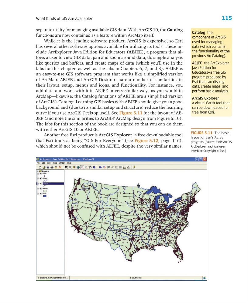
curve if you use ArcGIS Desktop itself. See Figure 5.11 for the layout of AEJEE (and note the similarities to ArcGIS’ ArcMap design from Figure 5.10).
The labs for this section of the book are designed so that you can do them
with either ArcGIS 10 or AEJEE.
Another free Esri product is ArcGIS Explorer, a free downloadable tool
that Esri touts as being “GIS For Everyone” (see Figure 5.12, page 116),
which should not be confused with AEJEE, despite the very similar names.
Catalog the
component of ArcGIS
used for managing
data (which contains
the functionality of the
previous ArcCatalog).
AEJEE the ArcExplorer
Java Edition for
Educators—a free GIS
program produced by
Esri that can display
data, create maps, and
perform basic analysis.
ArcGIS Explorer
a virtual Earth tool that
can be downloaded for
free from Esri.
FIGURE 5.11 The basic
layout of Esri’s AEJEE
program. (Source: Esri® ArcGIS
ArcExplorer graphical user
interface Copyright © Esri.)
What Kinds of GIS Are Available?
separate utility for managing available GIS data. With ArcGIS 10, the Catalog
functions are now contained as a feature within ArcMap itself.
While it is the leading software product, ArcGIS is expensive, so Esri
has several other software options available for utilizing its tools. These include ArcExplorer Java Edition for Educators (AEJEE), a program that allows a user to view GIS data, pan and zoom around data, do simple analysis
like queries and buffers, and create maps of data (which you’ll use in the
labs for this chapter, as well as the labs in Chapters 6, 7, and 8). AEJEE is
an easy-to-use GIS software program that works like a simplified version
of ArcMap. AEJEE and ArcGIS Desktop share a number of similarities in
their layout, setup, menus and icons, and functionality. For instance, you
add data and work with it in AEJEE in very similar ways as you would in
ArcMap—likewise, the Catalog functions of AEJEE are a simplified version
of ArcGIS’s Catalog. Learning GIS basics with AEJEE should give you a good
background and (due to its similar setup and structure) reduce the learning
curve if you use ArcGIS Desktop itself. See Figure 5.11 for the layout of AEJEE (and note the similarities to ArcGIS’ ArcMap design from Figure 5.10).
The labs for this section of the book are designed so that you can do them
with either ArcGIS 10 or AEJEE.
Another free Esri product is ArcGIS Explorer, a free downloadable tool
that Esri touts as being “GIS For Everyone” (see Figure 5.12, page 116),
which should not be confused with AEJEE, despite the very similar names.
Catalog the
component of ArcGIS
used for managing
data (which contains
the functionality of the
previous ArcCatalog).
AEJEE the ArcExplorer
Java Edition for
Educators—a free GIS
program produced by
Esri that can display
data, create maps, and
perform basic analysis.
ArcGIS Explorer
a virtual Earth tool that
can be downloaded for
free from Esri.
FIGURE 5.11 The basic
layout of Esri’s AEJEE
program. (Source: Esri® ArcGIS
ArcExplorer graphical user
interface Copyright © Esri.)