

114
Chapter 5 Working With Digital Spatial Data and GIS
such, was much simpler to use than the command-line interface. ArcView
went through several iterations to add a greater variety of functions and expansions to it to increase its analytical capabilities and was very commonly
used by the late 1990s. The final version of ArcView was version 3.3, which
is still available.
Esri released its newest software package, ArcGIS (version 8, which built
off the numbering of the previous Arc/Info versions) in stages between 1999
and 2001. ArcGIS was a blend of the analytical capabilities of Arc/Info with a
Windows graphical interface (similar to ArcView) in one package. As of this
writing, the most recent iteration of the software is ArcGIS Desktop 10. When
purchased, ArcGIS Desktop is available in three different varieties (which recycle the previous names of some products): ArcView, ArcEditor, and ArcInfo.
These can best be thought of as different levels of the same software package—all of them are considered ArcGIS Desktop, but the ArcView version has
the smallest number of functions, the ArcEditor version has the mid-range of
functions, and the ArcInfo version has the largest number of functions.
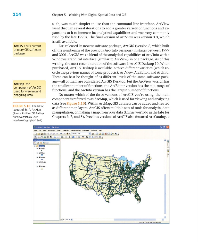
No matter which of the three versions of ArcGIS you’re using, the main
component is referred to as ArcMap, which is used for viewing and analyzing
data (see Figure 5.10). Within ArcMap, GIS datasets can be added and treated
as different map layers. ArcGIS offers multiple sets of tools for analysis, data
manipulation, or making a map from your data (things you’ll do in the labs for
Chapters 6, 7, and 8). Previous versions of ArcGIS also featured ArcCatalog, a
ArcGIS Esri’s current
primary GIS software
package.
ArcMap the
component of ArcGIS
used for viewing and
analyzing data.
FIGURE 5.10 The basic
layout of Esri’s ArcMap.
(Source: Esri® ArcGIS ArcMap
ArcView graphical user
interface Copyright © Esri.)
Chapter 5 Working With Digital Spatial Data and GIS
such, was much simpler to use than the command-line interface. ArcView
went through several iterations to add a greater variety of functions and expansions to it to increase its analytical capabilities and was very commonly
used by the late 1990s. The final version of ArcView was version 3.3, which
is still available.
Esri released its newest software package, ArcGIS (version 8, which built
off the numbering of the previous Arc/Info versions) in stages between 1999
and 2001. ArcGIS was a blend of the analytical capabilities of Arc/Info with a
Windows graphical interface (similar to ArcView) in one package. As of this
writing, the most recent iteration of the software is ArcGIS Desktop 10. When
purchased, ArcGIS Desktop is available in three different varieties (which recycle the previous names of some products): ArcView, ArcEditor, and ArcInfo.
These can best be thought of as different levels of the same software package—all of them are considered ArcGIS Desktop, but the ArcView version has
the smallest number of functions, the ArcEditor version has the mid-range of
functions, and the ArcInfo version has the largest number of functions.
No matter which of the three versions of ArcGIS you’re using, the main
component is referred to as ArcMap, which is used for viewing and analyzing
data (see Figure 5.10). Within ArcMap, GIS datasets can be added and treated
as different map layers. ArcGIS offers multiple sets of tools for analysis, data
manipulation, or making a map from your data (things you’ll do in the labs for
Chapters 6, 7, and 8). Previous versions of ArcGIS also featured ArcCatalog, a
ArcGIS Esri’s current
primary GIS software
package.
ArcMap the
component of ArcGIS
used for viewing and
analyzing data.
FIGURE 5.10 The basic
layout of Esri’s ArcMap.
(Source: Esri® ArcGIS ArcMap
ArcView graphical user
interface Copyright © Esri.)