

relatively fast while producing surfaces with little artifacts. The maximum value
was used because such values would be associated with remaining small nonground
features, if any, and which could be filtered in a second pass.
14.4.5 Repeat Pass and Point Labeling
Some data sets, where complex terrain is present, may require additional passes of the
multiscale erosion operator to refine the ground/nonground mask. If this is the case,
the input DSM is replaced by the estimated DTM and the process repeated. At this
point the only parameter that should be readjusted is the maximum width of
nonground features. A rule of thumb is to decrease this value by a factor of 4 in
every pass, since remaining nonground features are much smaller in every pass. The
repetition of the filtering stops if the number of cells that changed in the ground mask
between consecutive passes falls below a threshold, typically one percent of the total.
Alternatively, the process stops if a maximum number of iterations is reached, which
should be set to a small number. Here we use three. Once the ground/nonground mask
has been refined, the labeling of points is performed with a simple overlay operation in
which the point is labeled as ground if it falls within a ground cell.
-15
-10
-5
0
5
10
0
0.5
1
-15
-10
-5
0
5
10
0
0.5
1
-15
-10
-5
0
5
10
0
0.5
1
Input
M=2
M=4
Input
M=2
M=4
Input
M=2
M=4
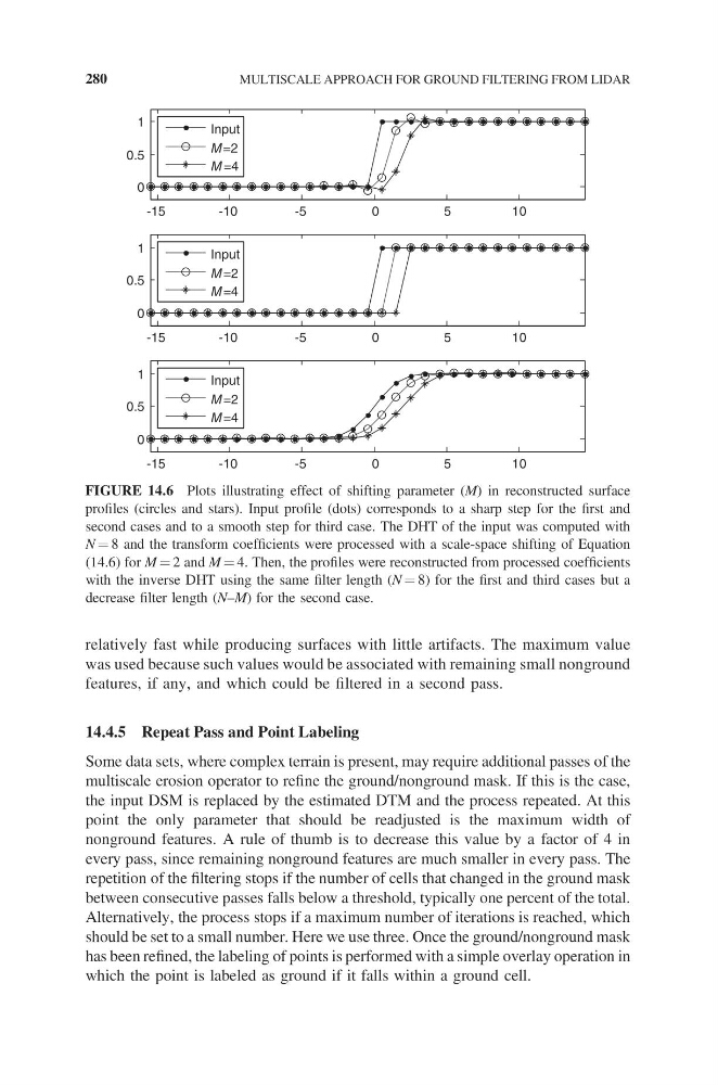
FIGURE 14.6 Plots illustrating effect of shifting parameter (M) in reconstructed surface
profiles (circles and stars). Input profile (dots) corresponds to a sharp step for the first and
second cases and to a smooth step for third case. The DHT of the input was computed with
N = 8 and the transform coefficients were processed with a scale-space shifting of Equation
(14.6) for M = 2 and M = 4. Then, the profiles were reconstructed from processed coefficients
with the inverse DHT using the same filter length (N = 8) for the first and third cases but a
decrease filter length (N–M) for the second case.
280
MULTISCALE APPROACH FOR GROUND FILTERING FROM LIDAR
was used because such values would be associated with remaining small nonground
features, if any, and which could be filtered in a second pass.
14.4.5 Repeat Pass and Point Labeling
Some data sets, where complex terrain is present, may require additional passes of the
multiscale erosion operator to refine the ground/nonground mask. If this is the case,
the input DSM is replaced by the estimated DTM and the process repeated. At this
point the only parameter that should be readjusted is the maximum width of
nonground features. A rule of thumb is to decrease this value by a factor of 4 in
every pass, since remaining nonground features are much smaller in every pass. The
repetition of the filtering stops if the number of cells that changed in the ground mask
between consecutive passes falls below a threshold, typically one percent of the total.
Alternatively, the process stops if a maximum number of iterations is reached, which
should be set to a small number. Here we use three. Once the ground/nonground mask
has been refined, the labeling of points is performed with a simple overlay operation in
which the point is labeled as ground if it falls within a ground cell.
-15
-10
-5
0
5
10
0
0.5
1
-15
-10
-5
0
5
10
0
0.5
1
-15
-10
-5
0
5
10
0
0.5
1
Input
M=2
M=4
Input
M=2
M=4
Input
M=2
M=4
FIGURE 14.6 Plots illustrating effect of shifting parameter (M) in reconstructed surface
profiles (circles and stars). Input profile (dots) corresponds to a sharp step for the first and
second cases and to a smooth step for third case. The DHT of the input was computed with
N = 8 and the transform coefficients were processed with a scale-space shifting of Equation
(14.6) for M = 2 and M = 4. Then, the profiles were reconstructed from processed coefficients
with the inverse DHT using the same filter length (N = 8) for the first and third cases but a
decrease filter length (N–M) for the second case.
280
MULTISCALE APPROACH FOR GROUND FILTERING FROM LIDAR