

applied only to the low-pass and first-order coefficients (z
q
0;0 and z
q
1;0 ), while higher
order coefficients along detected ground/nonground transitions are set to zero.
14.4.4 Ground Mask and DTM Generation
Once the MDHT coefficients of the terrain component have been estimated through
the erosion operation, the inverse MDHT transform is computed and the resynthesized surface used for generating a ground/nonground mask. A cell is labeled as
ground in the ground mask if its elevation value falls below the estimated surface plus
a tolerance value; otherwise it is labeled nonground. The suggested value for the
tolerance value corresponds to the vertical accuracy of the sensor, which is typically
around 15 cm (Habib, 2009).
In order to determine if the result is satisfactory, a preliminary DTM is produced
by masking the nonground features in the original DSM and filling the holes. Hole
filling in the raster mode can be efficiently accomplished through the nearestneighbor interpolation method. However, since evaluation is generally visual, a
more pleasant surface can be generated using a higher order interpolation. The
approach adopted here was to select the maximum elevation value of randomly
selected neighboring cells, where the probability for selecting a cell was set
proportional to the inverse distance. This method has the advantage of running
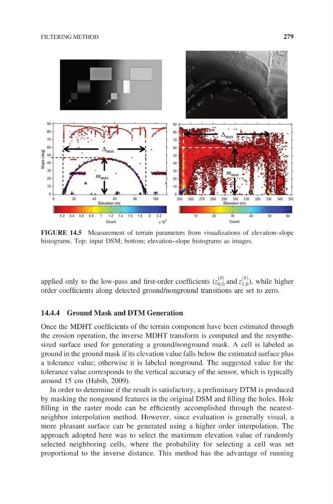
FIGURE 14.5 Measurement of terrain parameters from visualizations of elevation–slope
histograms. Top: input DSM; bottom; elevation–slope histograms as images.
FILTERING METHOD
279
q
0;0 and z
q
1;0 ), while higher
order coefficients along detected ground/nonground transitions are set to zero.
14.4.4 Ground Mask and DTM Generation
Once the MDHT coefficients of the terrain component have been estimated through
the erosion operation, the inverse MDHT transform is computed and the resynthesized surface used for generating a ground/nonground mask. A cell is labeled as
ground in the ground mask if its elevation value falls below the estimated surface plus
a tolerance value; otherwise it is labeled nonground. The suggested value for the
tolerance value corresponds to the vertical accuracy of the sensor, which is typically
around 15 cm (Habib, 2009).
In order to determine if the result is satisfactory, a preliminary DTM is produced
by masking the nonground features in the original DSM and filling the holes. Hole
filling in the raster mode can be efficiently accomplished through the nearestneighbor interpolation method. However, since evaluation is generally visual, a
more pleasant surface can be generated using a higher order interpolation. The
approach adopted here was to select the maximum elevation value of randomly
selected neighboring cells, where the probability for selecting a cell was set
proportional to the inverse distance. This method has the advantage of running
FIGURE 14.5 Measurement of terrain parameters from visualizations of elevation–slope
histograms. Top: input DSM; bottom; elevation–slope histograms as images.
FILTERING METHOD
279