

128
The shaping of the global protected area estate
Initiative
Areas of
coverage
Current status
(as of 2009)
Biogeographical
information used (code
and selected examples)
a
Decision - making
methods, tools,
planning units
b
Reference
Seascapes
Program
(Conservation
International)
areas of high
biodiversity,
ecological and
economic
connectivity,
cultural and
aesthetic value
3 priority
seascapes
(iiia, b) patterns of species
richness,
socioeconomics
and politics
expert opinion?
http://marine.conservation.org
Large Marine
Ecosystems
high
productivity
coastal waters
64 LMEs defi ned
globally; currently
16 international
GEF supported
LME projects
iiib, iv
bathymetry,
hydrography,
productivity, trophic
relationships
not a priority - setting
initiative
Sherman et al. (2007)
coral reef
hotspots
(Conservation
International)
coral reefs
10 hotspots
identifi ed in 2002,
but current status
unknown
ii
distributions of
restricted - range
fi sh, coral, lobsters
and molluscs
mapped onto
grid - based
database of threats
analytical: selection
based on highest
species richness,
endemism and threat
index; GIS; planning
units are 50,000 km
2
grid cells
Roberts et al. (2002)
IUCN Red List of
Threatened
Species
individual
threatened
species
basis for species
action plans;
current status
depends on the
species
ii
species - by - species
distributions; habitat
modelling
expert opinion? tools
and planning units
depend on the
species and data
available
www.iucnredlist.org
Particularly
Sensitive Sea
Areas (PSSA)
(International
Maritime
Organization)
areas with
shipping activity
12 PSSAs
established
o, i
distribution of
ecologically
important areas
within areas heavily
frequented by
shipping
ad hoc: proposals by
individual countries,
primary criterion is
threat from shipping;
no standardized
planning units
www.imo.org/environment/
mainframe.asp?topic_id
= 1357
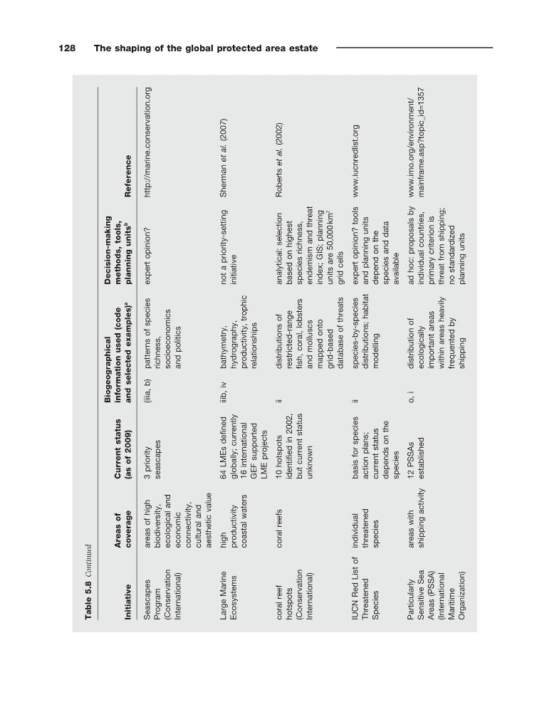
Table 5.8
Continued
The shaping of the global protected area estate
Initiative
Areas of
coverage
Current status
(as of 2009)
Biogeographical
information used (code
and selected examples)
a
Decision - making
methods, tools,
planning units
b
Reference
Seascapes
Program
(Conservation
International)
areas of high
biodiversity,
ecological and
economic
connectivity,
cultural and
aesthetic value
3 priority
seascapes
(iiia, b) patterns of species
richness,
socioeconomics
and politics
expert opinion?
http://marine.conservation.org
Large Marine
Ecosystems
high
productivity
coastal waters
64 LMEs defi ned
globally; currently
16 international
GEF supported
LME projects
iiib, iv
bathymetry,
hydrography,
productivity, trophic
relationships
not a priority - setting
initiative
Sherman et al. (2007)
coral reef
hotspots
(Conservation
International)
coral reefs
10 hotspots
identifi ed in 2002,
but current status
unknown
ii
distributions of
restricted - range
fi sh, coral, lobsters
and molluscs
mapped onto
grid - based
database of threats
analytical: selection
based on highest
species richness,
endemism and threat
index; GIS; planning
units are 50,000 km
2
grid cells
Roberts et al. (2002)
IUCN Red List of
Threatened
Species
individual
threatened
species
basis for species
action plans;
current status
depends on the
species
ii
species - by - species
distributions; habitat
modelling
expert opinion? tools
and planning units
depend on the
species and data
available
www.iucnredlist.org
Particularly
Sensitive Sea
Areas (PSSA)
(International
Maritime
Organization)
areas with
shipping activity
12 PSSAs
established
o, i
distribution of
ecologically
important areas
within areas heavily
frequented by
shipping
ad hoc: proposals by
individual countries,
primary criterion is
threat from shipping;
no standardized
planning units
www.imo.org/environment/
mainframe.asp?topic_id
= 1357
Table 5.8
Continued