

The distribution of diversity: challenges and applications
127
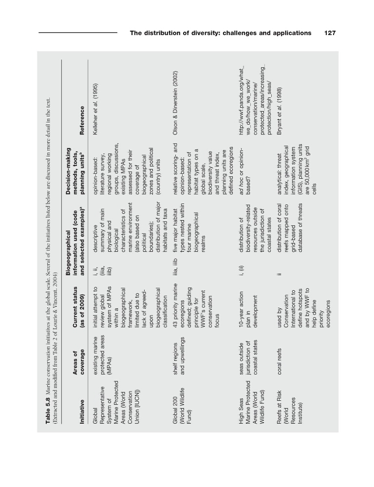
Table 5.8
Marine conservation initiatives at the global scale. Several of the initiatives listed below are discussed in more detail in the text.
(Extracted and modifi ed from Table 2 of Lourie & Vincent, 2004 )
Initiative
Areas of
coverage
Current status
(as of 2009)
Biogeographical
information used (code
and selected examples)
a
Decision - making
methods, tools,
planning units
b
Reference
Global
Representative
System of
Marine Protected
Areas (World
Conservation
Union [IUCN])
existing marine
protected areas
(MPAs)
initial attempt to
review global
system of MPAs
within a
biogeographical
framework,
limited due to
lack of agreed -
upon
biogeographical
classifi cation
i, ii,
(iiia,
iiib)
descriptive
summary of main
physical and
biological
characteristics of
marine environment
(also based on
political
boundaries);
distribution of major
habitats and taxa
opinion - based:
literature survey,
regional working
groups, discussions,
existing MPAs
assessed for their
coverage of
biogeographical
zones and political
(country) units
Kelleher et al. (1995)
Global 200
(World Wildlife
Fund)
shelf regions
and upwellings
43 priority marine
ecoregions
defi ned; guiding
principle for
WWF ’ s current
conservation
focus
iiia, iiib fi ve major habitat
types nested within
four marine
biogeographical
realms
relative scoring - and
opinion - based:
representation of
habitat types on a
global scale,
biodiversity value
and threat index,
planning units are
defi ned ecoregions
Olson & Dinerstein (2002)
High Seas
Marine Protected
Areas (World
Wildlife Fund)
seas outside
jurisdiction of
coastal states
10 - year action
plan in
development
i, (ii)
distribution of
biodiversity - related
resources outside
the jurisdiction of
coastal states
ad hoc or opinion -
based?
http://wwf.panda.org/what_
we_do/how_we_work/
conservation/marine/
protected_areas/increasing_
protection/high_seas/
Reefs at Risk
(World
Resources
Institute)
coral reefs
used by
Conservation
International to
defi ne hotspots
and by WWF to
help defi ne
priority
ecoregions
ii
distribution of coral
reefs mapped onto
grid - based
database of threats
analytical: threat
index, geographical
information system
(GIS), planning units
are 50,000 km
2
grid
cells
Bryant et al. (1998)
127
Table 5.8
Marine conservation initiatives at the global scale. Several of the initiatives listed below are discussed in more detail in the text.
(Extracted and modifi ed from Table 2 of Lourie & Vincent, 2004 )
Initiative
Areas of
coverage
Current status
(as of 2009)
Biogeographical
information used (code
and selected examples)
a
Decision - making
methods, tools,
planning units
b
Reference
Global
Representative
System of
Marine Protected
Areas (World
Conservation
Union [IUCN])
existing marine
protected areas
(MPAs)
initial attempt to
review global
system of MPAs
within a
biogeographical
framework,
limited due to
lack of agreed -
upon
biogeographical
classifi cation
i, ii,
(iiia,
iiib)
descriptive
summary of main
physical and
biological
characteristics of
marine environment
(also based on
political
boundaries);
distribution of major
habitats and taxa
opinion - based:
literature survey,
regional working
groups, discussions,
existing MPAs
assessed for their
coverage of
biogeographical
zones and political
(country) units
Kelleher et al. (1995)
Global 200
(World Wildlife
Fund)
shelf regions
and upwellings
43 priority marine
ecoregions
defi ned; guiding
principle for
WWF ’ s current
conservation
focus
iiia, iiib fi ve major habitat
types nested within
four marine
biogeographical
realms
relative scoring - and
opinion - based:
representation of
habitat types on a
global scale,
biodiversity value
and threat index,
planning units are
defi ned ecoregions
Olson & Dinerstein (2002)
High Seas
Marine Protected
Areas (World
Wildlife Fund)
seas outside
jurisdiction of
coastal states
10 - year action
plan in
development
i, (ii)
distribution of
biodiversity - related
resources outside
the jurisdiction of
coastal states
ad hoc or opinion -
based?
http://wwf.panda.org/what_
we_do/how_we_work/
conservation/marine/
protected_areas/increasing_
protection/high_seas/
Reefs at Risk
(World
Resources
Institute)
coral reefs
used by
Conservation
International to
defi ne hotspots
and by WWF to
help defi ne
priority
ecoregions
ii
distribution of coral
reefs mapped onto
grid - based
database of threats
analytical: threat
index, geographical
information system
(GIS), planning units
are 50,000 km
2
grid
cells
Bryant et al. (1998)