

116
The shaping of the global protected area estate
illustrating the difference in scale and resolution
between the two sets of WWF Ecoregional analyses.
As indicated, the key purpose of the Global 200 exercise was to identify high - priority examples of 21 major
habitat types (MHT) from each of seven biogeographical realms globally (in their framework, the Afrotropical,
Australasia, Indo - Malayan, Nearctic, Neotropical,
Oceania, Palearctic realms). Consideration was given
to the diversity of each MHT (species richness and
endemism, higher taxonomic uniqueness), the possession of extraordinary ecological or evolutionary phenomena (e.g. large intact vertebrate assemblages or
extraordinary adaptive radiations) and to the global
rarity of the MHT.
An example of the Global 200 is the Sumatran
Islands Lowland and Montane Forests ecoregion (No.
26), which is an Indo - Malayan realm ecoregion located
within Indonesia. Its MHT is tropical and subtropical
broadleaf forest and it comprises areas of northern
Sumatra and smaller islands to the north. Key biodiversity features warranting the inclusion of ecoregion
26 in the Global 200 priority - setting exercise include
the opportunity to conserve a number of endangered
and charismatic species, including Sumatran tigers,
2002b ; and see reply by Wikramanayake et al ., 2002 ).
Such problems arguably feature in any such exercise
of biogeographical delimitation, and especially so in
complex regions such as Indonesia, including as it does
the transitional biogeographical area of Wallacea (see
discussion of Wallacea in Cox, 2001 ).
So far, we have discussed only one aspect of the
WWF Ecoregions framework, which is the determination of the mapping units. Once the units are
determined, they may then be used in priority - setting
analyses, which may be undertaken reiteratively and
at varying scales of resolution.
Prior to the completion of the global map of 867
WWF Ecoregions, the same team had undertaken a
global analysis of priority ‘ ecoregions ’ at a slightly
coarser resolution (Olson & Dinerstein, 1998 ). This
priority - setting exercise was termed the Global 200
(see Figure 5.9 ), although in fact a total of 233 Global
200 ecoregions were identifi ed (Olson & Dinsertein,
1998 ), and Olson et al . (2001) refer to there being 237
units in this framework three years later. These 237
Global 200 Ecoregions contain 402 of the WWF
Ecoregions that emerged from the process of compiling
the eventual set of ecoregions as described above,
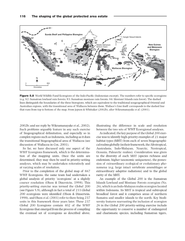
Figure 5.8 World Wildlife Fund Ecoregions of the Indo - Pacifi c (Indonesian excerpt). The numbers refer to specifi c ecoregions
(e.g. 82: Sumatran lowland rain forests; 83: Sumatran montane rain forests; 84: Mentawi Islands rain forest). The dashed
lines distinguish the boundaries of the three bioregions, which are equivalent to the traditional zoogeographical Oriental and
Australian regions, with the transitional area of Wallacea between them. Wallace ’ s Line itself corresponds to the dashed line
that runs from top to bottom of the map. From Jepson & Whittaker (2002b) , after Wikramanayake et al. (2001) .
Danau Toba
Danau Toba
Danau Toba
113 113
112 112
88 88
86 86
86 86
89 89
85 85
91 91
94 94
115 115
116 116
90 90
90 90
109 109
109 109
114 114
118 118
122 122
127 127
130 130
83 83
83 83
82
105
107
107
107
82
89
109
109
109
109
110 110 110
115
116
117
119
119
118
129
129
131 131
125 125
128 128
131
122
123
121
120
125
127
128
129
130
114
111
113
112
83
83
88
88
88
90
90 90
90
90
90
107
96
96
95
86
86
86
86
89
84
85
85
90
91
92
93
93 93
94
Middle Mahakam
Middle Mahakam
tectonic basin
tectonic basin
Middle Mahakam
tectonic basin
Sanglir-Talaud Islands
Sunda Shelf and Philippine Bioregion
Wallacea Bioregion
New Guinea
and Melanesia
Bioregion
Kilometres
0
800
N
The shaping of the global protected area estate
illustrating the difference in scale and resolution
between the two sets of WWF Ecoregional analyses.
As indicated, the key purpose of the Global 200 exercise was to identify high - priority examples of 21 major
habitat types (MHT) from each of seven biogeographical realms globally (in their framework, the Afrotropical,
Australasia, Indo - Malayan, Nearctic, Neotropical,
Oceania, Palearctic realms). Consideration was given
to the diversity of each MHT (species richness and
endemism, higher taxonomic uniqueness), the possession of extraordinary ecological or evolutionary phenomena (e.g. large intact vertebrate assemblages or
extraordinary adaptive radiations) and to the global
rarity of the MHT.
An example of the Global 200 is the Sumatran
Islands Lowland and Montane Forests ecoregion (No.
26), which is an Indo - Malayan realm ecoregion located
within Indonesia. Its MHT is tropical and subtropical
broadleaf forest and it comprises areas of northern
Sumatra and smaller islands to the north. Key biodiversity features warranting the inclusion of ecoregion
26 in the Global 200 priority - setting exercise include
the opportunity to conserve a number of endangered
and charismatic species, including Sumatran tigers,
2002b ; and see reply by Wikramanayake et al ., 2002 ).
Such problems arguably feature in any such exercise
of biogeographical delimitation, and especially so in
complex regions such as Indonesia, including as it does
the transitional biogeographical area of Wallacea (see
discussion of Wallacea in Cox, 2001 ).
So far, we have discussed only one aspect of the
WWF Ecoregions framework, which is the determination of the mapping units. Once the units are
determined, they may then be used in priority - setting
analyses, which may be undertaken reiteratively and
at varying scales of resolution.
Prior to the completion of the global map of 867
WWF Ecoregions, the same team had undertaken a
global analysis of priority ‘ ecoregions ’ at a slightly
coarser resolution (Olson & Dinerstein, 1998 ). This
priority - setting exercise was termed the Global 200
(see Figure 5.9 ), although in fact a total of 233 Global
200 ecoregions were identifi ed (Olson & Dinsertein,
1998 ), and Olson et al . (2001) refer to there being 237
units in this framework three years later. These 237
Global 200 Ecoregions contain 402 of the WWF
Ecoregions that emerged from the process of compiling
the eventual set of ecoregions as described above,
Figure 5.8 World Wildlife Fund Ecoregions of the Indo - Pacifi c (Indonesian excerpt). The numbers refer to specifi c ecoregions
(e.g. 82: Sumatran lowland rain forests; 83: Sumatran montane rain forests; 84: Mentawi Islands rain forest). The dashed
lines distinguish the boundaries of the three bioregions, which are equivalent to the traditional zoogeographical Oriental and
Australian regions, with the transitional area of Wallacea between them. Wallace ’ s Line itself corresponds to the dashed line
that runs from top to bottom of the map. From Jepson & Whittaker (2002b) , after Wikramanayake et al. (2001) .
Danau Toba
Danau Toba
Danau Toba
113 113
112 112
88 88
86 86
86 86
89 89
85 85
91 91
94 94
115 115
116 116
90 90
90 90
109 109
109 109
114 114
118 118
122 122
127 127
130 130
83 83
83 83
82
105
107
107
107
82
89
109
109
109
109
110 110 110
115
116
117
119
119
118
129
129
131 131
125 125
128 128
131
122
123
121
120
125
127
128
129
130
114
111
113
112
83
83
88
88
88
90
90 90
90
90
90
107
96
96
95
86
86
86
86
89
84
85
85
90
91
92
93
93 93
94
Middle Mahakam
Middle Mahakam
tectonic basin
tectonic basin
Middle Mahakam
tectonic basin
Sanglir-Talaud Islands
Sunda Shelf and Philippine Bioregion
Wallacea Bioregion
New Guinea
and Melanesia
Bioregion
Kilometres
0
800
N