

The distribution of diversity: challenges and applications
115
We may illustrate this once again with reference to
Indonesia, where the regional ecoregions map (Figure
5.8 ) demonstrated varying degrees of congruence and
confl ict with pre - established conservation planning
frameworks, and in which ecoregional boundaries
crossed several key major ecosystem reserves within
the Indonesian protected area system (Jepson &
Whittaker, 2002b ).
In particular, the goal of distinguishing mesoecosystems, representing ‘ dynamic arenas ’ , appeared not to
have been met in some parts of this complex island
region. So, for example, the large (1.8 million ha)
Middle Mahakam wetland system in East Kalimantan
appears to be a clear example of a functionally (hydrologically) interconnected system, but was subdivided
by Wikramanayake et al . (2001) on the basis of dominant vegetation formations into a complex of three
WWF Ecoregions, when arguably they might be considered the next tier down in the hierarchy.
On the other hand, two small islands (Sangihe -
Talaud and Bangai - Sula) were combined with lowland
areas of Sulawesi into a single ecoregion, despite a lack
of the ecological fl ows and linkages that are invoked
within the ecoregion rationale (Jepson & Whittaker,
approach to identifying regional - scale ecosystems, the
WWF Ecoregions scheme also aimed to allow conservation attention to be focused on a representative array
of the world ’ s major distinct ecosystems (Olson et al .,
2001 ).
An important goal of the WWF Ecoregions framework was that the resulting units should ‘ approximate
the dynamic arena within which ecological processes
most strongly interact ’ , thereby allowing conservation
planning that considered not only distributions but
also the ecological phenomena involved, such as
migrations, predator/prey interactions among megafauna, or the ecosystem functional properties arising
from vegetation/climate interactions across large forested regions (Olson et al ., 2001 , p. 937).
These key goals, of (i) identifying regional - scale ecosystems that are (ii) biogeographically representative
and which (iii) maximize internal fl ows and linkages,
are of course extremely diffi cult to optimize in a single
scheme, particularly given the inconsistencies of data
available and the differing spatial scales of pattern and
process evident in different regions of the world. Hence,
it is relatively easy to fi nd fault with particular parts of
the WWF Ecoregional framework.
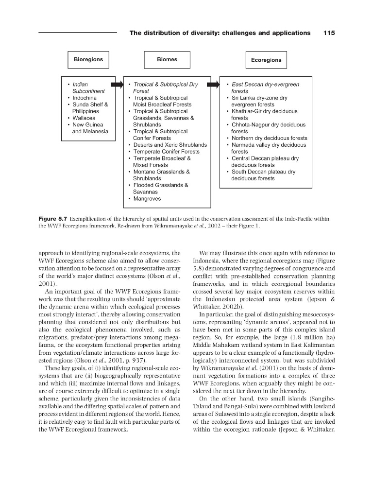
Figure 5.7 Exemplifi cation of the hierarchy of spatial units used in the conservation assessment of the Indo - Pacifi c within
the WWF Ecoregions framework. Re - drawn from Wikramanayake et al. , 2002 – their Figure 1.
Biomes
Ecoregions
Bioregions
• Tropical & Subtropical Dry
Forest
• Tropical & Subtropical
Moist Broadleaf Forests
• Tropical & Subtropical
Grasslands, Savannas &
Shrublands
• Tropical & Subtropical
Conifer Forests
• Deserts and Xeric Shrublands
• Temperate Conifer Forests
• Temperate Broadleaf &
Mixed Forests
• Montane Grasslands &
Shrublands
• Flooded Grasslands &
Savannas
• Mangroves
• East Deccan dry-evergreen
forests
• Sri Lanka dry-zone dry
evergreen forests
• Khathiar-Gir dry deciduous
forests
• Chhota-Nagpur dry deciduous
forests
• Northern dry deciduous forests
• Narmada valley dry deciduous
forests
• Central Deccan plateau dry
deciduous forests
• South Deccan plateau dry
deciduous forests
• Indian
Subcontinent
• Indochina
• Sunda Shelf &
Philippines
• Wallacea
• New Guinea
and Melanesia
115
We may illustrate this once again with reference to
Indonesia, where the regional ecoregions map (Figure
5.8 ) demonstrated varying degrees of congruence and
confl ict with pre - established conservation planning
frameworks, and in which ecoregional boundaries
crossed several key major ecosystem reserves within
the Indonesian protected area system (Jepson &
Whittaker, 2002b ).
In particular, the goal of distinguishing mesoecosystems, representing ‘ dynamic arenas ’ , appeared not to
have been met in some parts of this complex island
region. So, for example, the large (1.8 million ha)
Middle Mahakam wetland system in East Kalimantan
appears to be a clear example of a functionally (hydrologically) interconnected system, but was subdivided
by Wikramanayake et al . (2001) on the basis of dominant vegetation formations into a complex of three
WWF Ecoregions, when arguably they might be considered the next tier down in the hierarchy.
On the other hand, two small islands (Sangihe -
Talaud and Bangai - Sula) were combined with lowland
areas of Sulawesi into a single ecoregion, despite a lack
of the ecological fl ows and linkages that are invoked
within the ecoregion rationale (Jepson & Whittaker,
approach to identifying regional - scale ecosystems, the
WWF Ecoregions scheme also aimed to allow conservation attention to be focused on a representative array
of the world ’ s major distinct ecosystems (Olson et al .,
2001 ).
An important goal of the WWF Ecoregions framework was that the resulting units should ‘ approximate
the dynamic arena within which ecological processes
most strongly interact ’ , thereby allowing conservation
planning that considered not only distributions but
also the ecological phenomena involved, such as
migrations, predator/prey interactions among megafauna, or the ecosystem functional properties arising
from vegetation/climate interactions across large forested regions (Olson et al ., 2001 , p. 937).
These key goals, of (i) identifying regional - scale ecosystems that are (ii) biogeographically representative
and which (iii) maximize internal fl ows and linkages,
are of course extremely diffi cult to optimize in a single
scheme, particularly given the inconsistencies of data
available and the differing spatial scales of pattern and
process evident in different regions of the world. Hence,
it is relatively easy to fi nd fault with particular parts of
the WWF Ecoregional framework.
Figure 5.7 Exemplifi cation of the hierarchy of spatial units used in the conservation assessment of the Indo - Pacifi c within
the WWF Ecoregions framework. Re - drawn from Wikramanayake et al. , 2002 – their Figure 1.
Biomes
Ecoregions
Bioregions
• Tropical & Subtropical Dry
Forest
• Tropical & Subtropical
Moist Broadleaf Forests
• Tropical & Subtropical
Grasslands, Savannas &
Shrublands
• Tropical & Subtropical
Conifer Forests
• Deserts and Xeric Shrublands
• Temperate Conifer Forests
• Temperate Broadleaf &
Mixed Forests
• Montane Grasslands &
Shrublands
• Flooded Grasslands &
Savannas
• Mangroves
• East Deccan dry-evergreen
forests
• Sri Lanka dry-zone dry
evergreen forests
• Khathiar-Gir dry deciduous
forests
• Chhota-Nagpur dry deciduous
forests
• Northern dry deciduous forests
• Narmada valley dry deciduous
forests
• Central Deccan plateau dry
deciduous forests
• South Deccan plateau dry
deciduous forests
• Indian
Subcontinent
• Indochina
• Sunda Shelf &
Philippines
• Wallacea
• New Guinea
and Melanesia