

90
Basic biogeography: estimating biodiversity and mapping nature
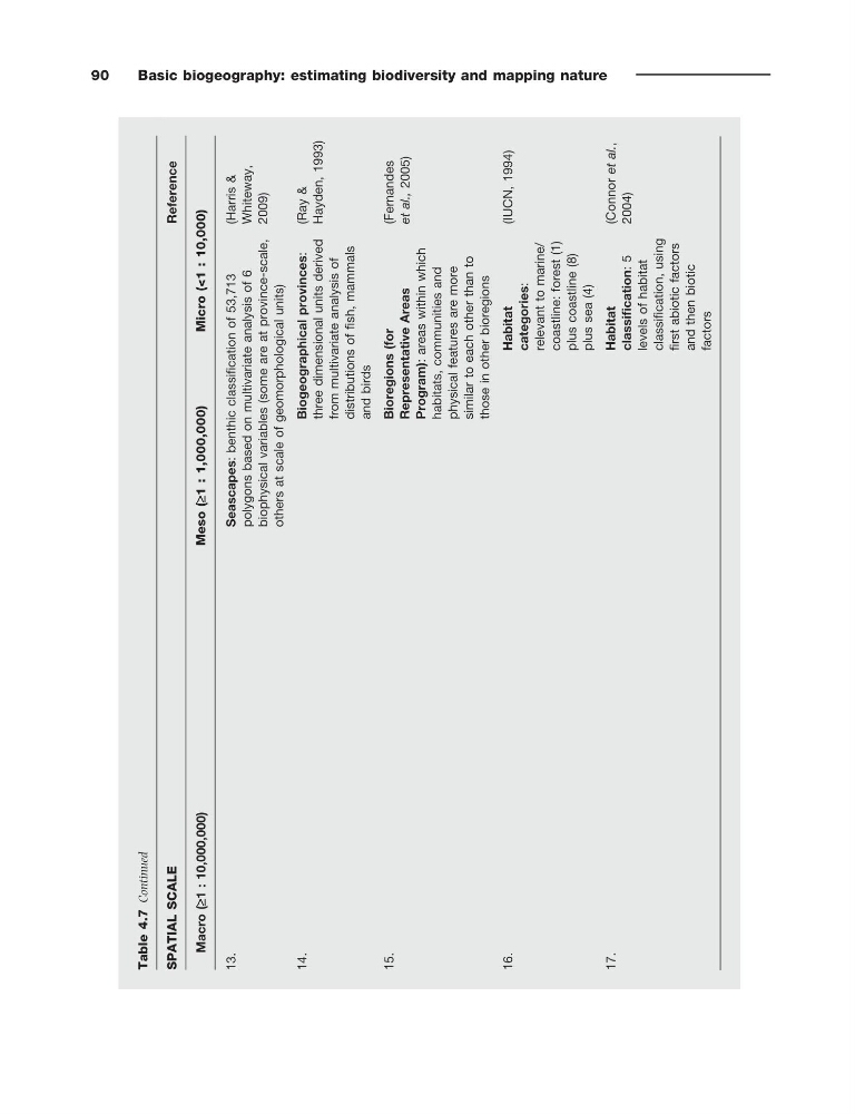
13.
Seascapes:
benthic classification of 53,713
polygons based on multivariate analysis
of 6
biophysical variables (some are at province-scale,
others at scale of geomorphological units)
(Harris &
Whiteway,
2009)
14.
Biogeographical provinces:
three dimensional units derived
from multivariate analysis of
distributions of fish, mammals
and birds
(Ray &
Hayden, 1993)
15.
Bioregions (for
Representative Areas
Program):
areas within which
habitats, communities
and
physical features are
more
similar to each other than
to
those
in other bioregions
(Fernandes
et al., 2005)
16.
Habitat
categories:
relevant to marine/
coastline: forest
(1)
plus coastline (8)
plus sea
(4)
(IUCN, 1994)
17.
Habitat
classification:
5
levels
of habitat
classification, using
first abiotic factors
and then biotic
factors
(Connor et al.,
2004)
Table 4.7
Continued
SPATIAL SCALE
Reference
Macro (≥1 : 10,000,000)
Meso (≥1 : 1,000,000)
Micro (<1 : 10,000)
Basic biogeography: estimating biodiversity and mapping nature
13.
Seascapes:
benthic classification of 53,713
polygons based on multivariate analysis
of 6
biophysical variables (some are at province-scale,
others at scale of geomorphological units)
(Harris &
Whiteway,
2009)
14.
Biogeographical provinces:
three dimensional units derived
from multivariate analysis of
distributions of fish, mammals
and birds
(Ray &
Hayden, 1993)
15.
Bioregions (for
Representative Areas
Program):
areas within which
habitats, communities
and
physical features are
more
similar to each other than
to
those
in other bioregions
(Fernandes
et al., 2005)
16.
Habitat
categories:
relevant to marine/
coastline: forest
(1)
plus coastline (8)
plus sea
(4)
(IUCN, 1994)
17.
Habitat
classification:
5
levels
of habitat
classification, using
first abiotic factors
and then biotic
factors
(Connor et al.,
2004)
Table 4.7
Continued
SPATIAL SCALE
Reference
Macro (≥1 : 10,000,000)
Meso (≥1 : 1,000,000)
Micro (<1 : 10,000)