

THE PELAGIC ENVIRONMENT OF THE OPEN OCEAN
65
ITCZ
Indonesia
Andes
35 .0
180°
90°
Indonesia
Andes
180°
90°
ITCZ
Th er m oc lin e
Th erm oc lin e
35.0
A
B
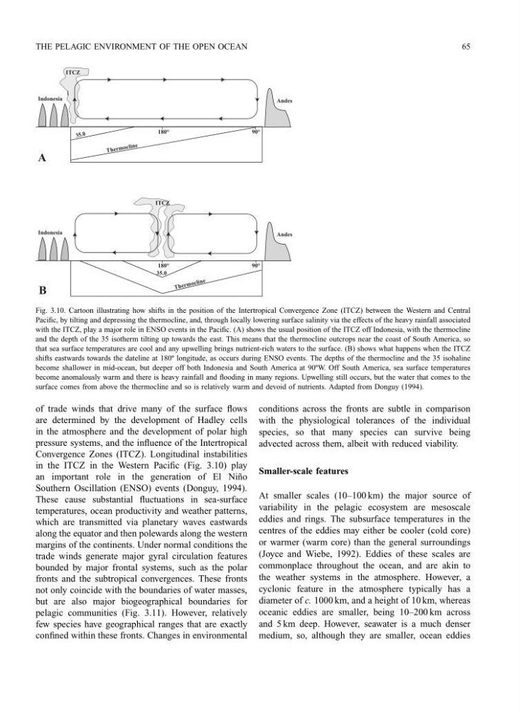
Fig. 3.10. Cartoon illustrating how shifts in the position of the Intertropical Convergence Zone (ITCZ) between the Western and Central
Pacific, by tilting and depressing the thermocline, and, through locally lowering surface salinity via the effects of the heavy rainfall associated
with the ITCZ, play a major role in ENSO events in the Pacific. (A) shows the usual position of the ITCZ off Indonesia, with the thermocline
and the depth of the 35 isotherm tilting up towards the east. This means that the thermocline outcrops near the coast of South America, so
that sea surface temperatures are cool and any upwelling brings nutrient-rich waters to the surface. (B) shows what happens when the ITCZ
shifts eastwards towards the dateline at 180º longitude, as occurs during ENSO events. The depths of the thermocline and the 35 isohaline
become shallower in mid-ocean, but deeper off both Indonesia and South America at 90ºW. Off South America, sea surface temperatures
become anomalously warm and there is heavy rainfall and flooding in many regions. Upwelling still occurs, but the water that comes to the
surface comes from above the thermocline and so is relatively warm and devoid of nutrients. Adapted from Donguy (1994).
of trade winds that drive many of the surface flows
are determined by the development of Hadley cells
in the atmosphere and the development of polar high
pressure systems, and the influence of the Intertropical
Convergence Zones (ITCZ). Longitudinal instabilities
in the ITCZ in the Western Pacific (Fig. 3.10) play
an important role in the generation of El Ni˜ no
Southern Oscillation (ENSO) events (Donguy, 1994).
These cause substantial fluctuations in sea-surface
temperatures, ocean productivity and weather patterns,
which are transmitted via planetary waves eastwards
along the equator and then polewards along the western
margins of the continents. Under normal conditions the
trade winds generate major gyral circulation features
bounded by major frontal systems, such as the polar
fronts and the subtropical convergences. These fronts
not only coincide with the boundaries of water masses,
but are also major biogeographical boundaries for
pelagic communities (Fig. 3.11). However, relatively
few species have geographical ranges that are exactly
confined within these fronts. Changes in environmental
conditions across the fronts are subtle in comparison
with the physiological tolerances of the individual
species, so that many species can survive being
advected across them, albeit with reduced viability.
Smaller-scale features
At smaller scales (10–100 km) the major source of
variability in the pelagic ecosystem are mesoscale
eddies and rings. The subsurface temperatures in the
centres of the eddies may either be cooler (cold core)
or warmer (warm core) than the general surroundings
(Joyce and Wiebe, 1992). Eddies of these scales are
commonplace throughout the ocean, and are akin to
the weather systems in the atmosphere. However, a
cyclonic feature in the atmosphere typically has a
diameter of c. 1000 km, and a height of 10 km, whereas
oceanic eddies are smaller, being 10–200 km across
and 5 km deep. However, seawater is a much denser
medium, so, although they are smaller, ocean eddies
65
ITCZ
Indonesia
Andes
35 .0
180°
90°
Indonesia
Andes
180°
90°
ITCZ
Th er m oc lin e
Th erm oc lin e
35.0
A
B
Fig. 3.10. Cartoon illustrating how shifts in the position of the Intertropical Convergence Zone (ITCZ) between the Western and Central
Pacific, by tilting and depressing the thermocline, and, through locally lowering surface salinity via the effects of the heavy rainfall associated
with the ITCZ, play a major role in ENSO events in the Pacific. (A) shows the usual position of the ITCZ off Indonesia, with the thermocline
and the depth of the 35 isotherm tilting up towards the east. This means that the thermocline outcrops near the coast of South America, so
that sea surface temperatures are cool and any upwelling brings nutrient-rich waters to the surface. (B) shows what happens when the ITCZ
shifts eastwards towards the dateline at 180º longitude, as occurs during ENSO events. The depths of the thermocline and the 35 isohaline
become shallower in mid-ocean, but deeper off both Indonesia and South America at 90ºW. Off South America, sea surface temperatures
become anomalously warm and there is heavy rainfall and flooding in many regions. Upwelling still occurs, but the water that comes to the
surface comes from above the thermocline and so is relatively warm and devoid of nutrients. Adapted from Donguy (1994).
of trade winds that drive many of the surface flows
are determined by the development of Hadley cells
in the atmosphere and the development of polar high
pressure systems, and the influence of the Intertropical
Convergence Zones (ITCZ). Longitudinal instabilities
in the ITCZ in the Western Pacific (Fig. 3.10) play
an important role in the generation of El Ni˜ no
Southern Oscillation (ENSO) events (Donguy, 1994).
These cause substantial fluctuations in sea-surface
temperatures, ocean productivity and weather patterns,
which are transmitted via planetary waves eastwards
along the equator and then polewards along the western
margins of the continents. Under normal conditions the
trade winds generate major gyral circulation features
bounded by major frontal systems, such as the polar
fronts and the subtropical convergences. These fronts
not only coincide with the boundaries of water masses,
but are also major biogeographical boundaries for
pelagic communities (Fig. 3.11). However, relatively
few species have geographical ranges that are exactly
confined within these fronts. Changes in environmental
conditions across the fronts are subtle in comparison
with the physiological tolerances of the individual
species, so that many species can survive being
advected across them, albeit with reduced viability.
Smaller-scale features
At smaller scales (10–100 km) the major source of
variability in the pelagic ecosystem are mesoscale
eddies and rings. The subsurface temperatures in the
centres of the eddies may either be cooler (cold core)
or warmer (warm core) than the general surroundings
(Joyce and Wiebe, 1992). Eddies of these scales are
commonplace throughout the ocean, and are akin to
the weather systems in the atmosphere. However, a
cyclonic feature in the atmosphere typically has a
diameter of c. 1000 km, and a height of 10 km, whereas
oceanic eddies are smaller, being 10–200 km across
and 5 km deep. However, seawater is a much denser
medium, so, although they are smaller, ocean eddies