

276
Paul A. TYLER
a
b
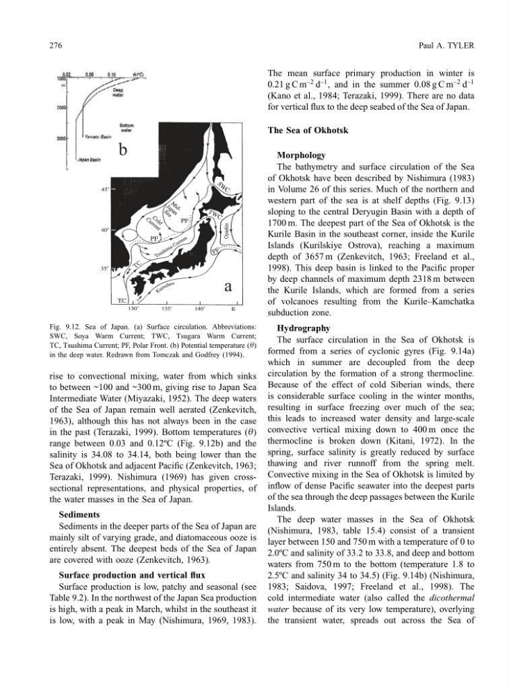
Fig. 9.12. Sea of Japan. (a) Surface circulation. Abbreviations:
SWC, Soya Warm Current; TWC, Tsugara Warm Current;
TC, Tsushima Current; PF, Polar Front. (b) Potential temperature (q)
in the deep water. Redrawn from Tomczak and Godfrey (1994).
rise to convectional mixing, water from which sinks
to between ~100 and ~300 m, giving rise to Japan Sea
Intermediate Water (Miyazaki, 1952). The deep waters
of the Sea of Japan remain well aerated (Zenkevitch,
1963), although this has not always been in the case
in the past (Terazaki, 1999). Bottom temperatures (q)
range between 0.03 and 0.12ºC (Fig. 9.12b) and the
salinity is 34.08 to 34.14, both being lower than the
Sea of Okhotsk and adjacent Pacific (Zenkevitch, 1963;
Terazaki, 1999). Nishimura (1969) has given crosssectional representations, and physical properties, of
the water masses in the Sea of Japan.
Sediments
Sediments in the deeper parts of the Sea of Japan are
mainly silt of varying grade, and diatomaceous ooze is
entirely absent. The deepest beds of the Sea of Japan
are covered with ooze (Zenkevitch, 1963).
Surface production and vertical flux
Surface production is low, patchy and seasonal (see
Table 9.2). In the northwest of the Japan Sea production
is high, with a peak in March, whilst in the southeast it
is low, with a peak in May (Nishimura, 1969, 1983).
The mean surface primary production in winter is
0.21 g C m
−2 d
−1 , and in the summer 0.08 g C m
−2 d
−1
(Kano et al., 1984; Terazaki, 1999). There are no data
for vertical flux to the deep seabed of the Sea of Japan.
The Sea of Okhotsk
Morphology
The bathymetry and surface circulation of the Sea
of Okhotsk have been described by Nishimura (1983)
in Volume 26 of this series. Much of the northern and
western part of the sea is at shelf depths (Fig. 9.13)
sloping to the central Deryugin Basin with a depth of
1700 m. The deepest part of the Sea of Okhotsk is the
Kurile Basin in the southeast corner, inside the Kurile
Islands (Kurilskiye Ostrova), reaching a maximum
depth of 3657 m (Zenkevitch, 1963; Freeland et al.,
1998). This deep basin is linked to the Pacific proper
by deep channels of maximum depth 2318 m between
the Kurile Islands, which are formed from a series
of volcanoes resulting from the Kurile–Kamchatka
subduction zone.
Hydrography
The surface circulation in the Sea of Okhotsk is
formed from a series of cyclonic gyres (Fig. 9.14a)
which in summer are decoupled from the deep
circulation by the formation of a strong thermocline.
Because of the effect of cold Siberian winds, there
is considerable surface cooling in the winter months,
resulting in surface freezing over much of the sea;
this leads to increased water density and large-scale
convective vertical mixing down to 400 m once the
thermocline is broken down (Kitani, 1972). In the
spring, surface salinity is greatly reduced by surface
thawing and river runnoff from the spring melt.
Convective mixing in the Sea of Okhotsk is limited by
inflow of dense Pacific seawater into the deepest parts
of the sea through the deep passages between the Kurile
Islands.
The deep water masses in the Sea of Okhotsk
(Nishimura, 1983, table 15.4) consist of a transient
layer between 150 and 750 m with a temperature of 0 to
2.0ºC and salinity of 33.2 to 33.8, and deep and bottom
waters from 750 m to the bottom (temperature 1.8 to
2.5ºC and salinity 34 to 34.5) (Fig. 9.14b) (Nishimura,
1983; Saidova, 1997; Freeland et al., 1998). The
cold intermediate water (also called the dicothermal
water because of its very low temperature), overlying
the transient water, spreads out across the Sea of
Paul A. TYLER
a
b
Fig. 9.12. Sea of Japan. (a) Surface circulation. Abbreviations:
SWC, Soya Warm Current; TWC, Tsugara Warm Current;
TC, Tsushima Current; PF, Polar Front. (b) Potential temperature (q)
in the deep water. Redrawn from Tomczak and Godfrey (1994).
rise to convectional mixing, water from which sinks
to between ~100 and ~300 m, giving rise to Japan Sea
Intermediate Water (Miyazaki, 1952). The deep waters
of the Sea of Japan remain well aerated (Zenkevitch,
1963), although this has not always been in the case
in the past (Terazaki, 1999). Bottom temperatures (q)
range between 0.03 and 0.12ºC (Fig. 9.12b) and the
salinity is 34.08 to 34.14, both being lower than the
Sea of Okhotsk and adjacent Pacific (Zenkevitch, 1963;
Terazaki, 1999). Nishimura (1969) has given crosssectional representations, and physical properties, of
the water masses in the Sea of Japan.
Sediments
Sediments in the deeper parts of the Sea of Japan are
mainly silt of varying grade, and diatomaceous ooze is
entirely absent. The deepest beds of the Sea of Japan
are covered with ooze (Zenkevitch, 1963).
Surface production and vertical flux
Surface production is low, patchy and seasonal (see
Table 9.2). In the northwest of the Japan Sea production
is high, with a peak in March, whilst in the southeast it
is low, with a peak in May (Nishimura, 1969, 1983).
The mean surface primary production in winter is
0.21 g C m
−2 d
−1 , and in the summer 0.08 g C m
−2 d
−1
(Kano et al., 1984; Terazaki, 1999). There are no data
for vertical flux to the deep seabed of the Sea of Japan.
The Sea of Okhotsk
Morphology
The bathymetry and surface circulation of the Sea
of Okhotsk have been described by Nishimura (1983)
in Volume 26 of this series. Much of the northern and
western part of the sea is at shelf depths (Fig. 9.13)
sloping to the central Deryugin Basin with a depth of
1700 m. The deepest part of the Sea of Okhotsk is the
Kurile Basin in the southeast corner, inside the Kurile
Islands (Kurilskiye Ostrova), reaching a maximum
depth of 3657 m (Zenkevitch, 1963; Freeland et al.,
1998). This deep basin is linked to the Pacific proper
by deep channels of maximum depth 2318 m between
the Kurile Islands, which are formed from a series
of volcanoes resulting from the Kurile–Kamchatka
subduction zone.
Hydrography
The surface circulation in the Sea of Okhotsk is
formed from a series of cyclonic gyres (Fig. 9.14a)
which in summer are decoupled from the deep
circulation by the formation of a strong thermocline.
Because of the effect of cold Siberian winds, there
is considerable surface cooling in the winter months,
resulting in surface freezing over much of the sea;
this leads to increased water density and large-scale
convective vertical mixing down to 400 m once the
thermocline is broken down (Kitani, 1972). In the
spring, surface salinity is greatly reduced by surface
thawing and river runnoff from the spring melt.
Convective mixing in the Sea of Okhotsk is limited by
inflow of dense Pacific seawater into the deepest parts
of the sea through the deep passages between the Kurile
Islands.
The deep water masses in the Sea of Okhotsk
(Nishimura, 1983, table 15.4) consist of a transient
layer between 150 and 750 m with a temperature of 0 to
2.0ºC and salinity of 33.2 to 33.8, and deep and bottom
waters from 750 m to the bottom (temperature 1.8 to
2.5ºC and salinity 34 to 34.5) (Fig. 9.14b) (Nishimura,
1983; Saidova, 1997; Freeland et al., 1998). The
cold intermediate water (also called the dicothermal
water because of its very low temperature), overlying
the transient water, spreads out across the Sea of