

Glacial erosion
73
grooves) of up to half metre depth found on steep surfaces. In conjunction with these forms
appear grooves, basins, folds and curved and winding channels (Kor et al., 1991). Their
origin is very controversial. The most accepted hypothesis is the one explaining this
micromodelling as due to subglacial water action under pressure. Other authors, however,
defend the idea of abrasion processes (debris loaded basal ice), or erosive action produced
by the movement under pressure of water-saturated basal till (Gjessing, 1965; Gray, 1981).
2.3. Roches moutonn~es and other forms
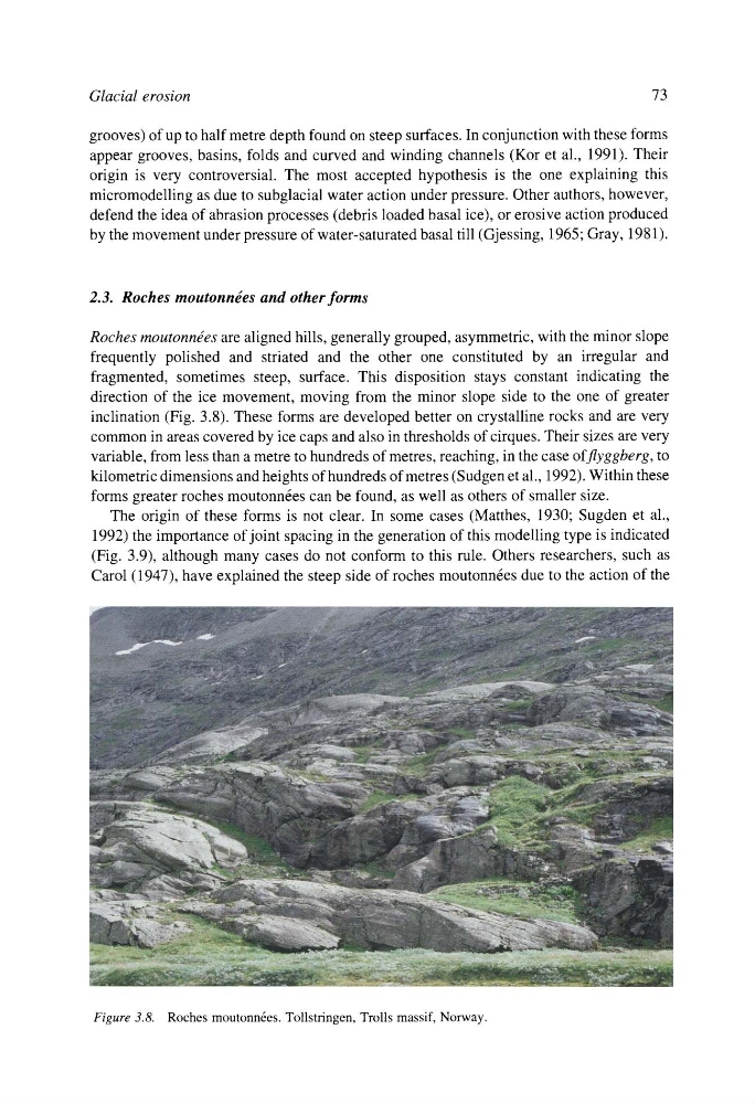
Roches moutonn~es are aligned hills, generally grouped, asymmetric, with the minor slope
frequently polished and striated and the other one constituted by an irregular and
fragmented, sometimes steep, surface. This disposition stays constant indicating the
direction of the ice movement, moving from the minor slope side to the one of greater
inclination (Fig. 3.8). These forms are developed better on crystalline rocks and are very
common in areas covered by ice caps and also in thresholds of cirques. Their sizes are very
variable, from less than a metre to hundreds of metres, reaching, in the case offlyggberg, to
kilometric dimensions and heights of hundreds of metres (Sudgen et al., 1992). Within these
forms greater roches moutonn6es can be found, as well as others of smaller size.
The origin of these forms is not clear. In some cases (Matthes, 1930; Sugden et al.,
1992) the importance of joint spacing in the generation of this modelling type is indicated
(Fig. 3.9), although many cases do not conform to this rule. Others researchers, such as
Carol (1947), have explained the steep side of roches moutonn6es due to the action of the
Figure 3.8. Roches moutonn6es. Tollstringen, Trolls massif, Norway.
73
grooves) of up to half metre depth found on steep surfaces. In conjunction with these forms
appear grooves, basins, folds and curved and winding channels (Kor et al., 1991). Their
origin is very controversial. The most accepted hypothesis is the one explaining this
micromodelling as due to subglacial water action under pressure. Other authors, however,
defend the idea of abrasion processes (debris loaded basal ice), or erosive action produced
by the movement under pressure of water-saturated basal till (Gjessing, 1965; Gray, 1981).
2.3. Roches moutonn~es and other forms
Roches moutonn~es are aligned hills, generally grouped, asymmetric, with the minor slope
frequently polished and striated and the other one constituted by an irregular and
fragmented, sometimes steep, surface. This disposition stays constant indicating the
direction of the ice movement, moving from the minor slope side to the one of greater
inclination (Fig. 3.8). These forms are developed better on crystalline rocks and are very
common in areas covered by ice caps and also in thresholds of cirques. Their sizes are very
variable, from less than a metre to hundreds of metres, reaching, in the case offlyggberg, to
kilometric dimensions and heights of hundreds of metres (Sudgen et al., 1992). Within these
forms greater roches moutonn6es can be found, as well as others of smaller size.
The origin of these forms is not clear. In some cases (Matthes, 1930; Sugden et al.,
1992) the importance of joint spacing in the generation of this modelling type is indicated
(Fig. 3.9), although many cases do not conform to this rule. Others researchers, such as
Carol (1947), have explained the steep side of roches moutonn6es due to the action of the
Figure 3.8. Roches moutonn6es. Tollstringen, Trolls massif, Norway.