

Tropical landforms
539
+0.6 ~
S
S
B
s
0.8 ~
X
,
, ~
2.7 ~
7.8 ~
Max
C
s
~ ~,~3.0 o Max
x
4.3 ~
~
~
MaXMi n
2~53.5 ~ Max
.
31,,~: 0 ~
Mm
Max
",..,.~k,~.5 ~
x
+2.7 ~
~3.2
~
E
"'"--'-4"'-S
Segment
Max Maximum Segment
Min
Minimum Segment
X
Convex element
V
Concave element
2.5~
Max
Max
~
V
S
S
3.4 ~
S
V
~3o
~o
s
5"2~
X
"~~~"'~.3
o
Max o
m
4.0 ~
S
0
..........
v
0
lOOm
vert.exagg, x 3
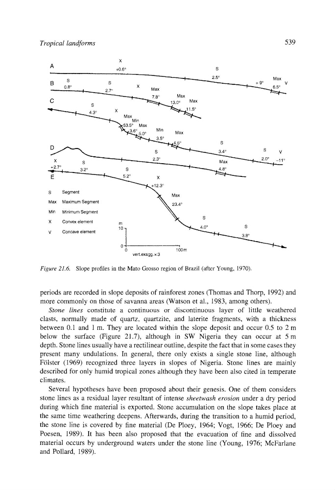
Figure 21.6. Slope profiles in the Mato Grosso region of Brazil (after Young, 1970).
periods are recorded in slope deposits of rainforest zones (Thomas and Thorp, 1992) and
more commonly on those of savanna areas (Watson et al., 1983, among others).
Stone lines constitute a continuous or discontinuous layer of little weathered
clasts, normally made of quartz, quartzite, and laterite fragments, with a thickness
between 0.1 and 1 m. They are located within the slope deposit and occur 0.5 to 2 m
below the surface (Figure 21.7), although in SW Nigeria they can occur at 5 m
depth. Stone lines usually have a rectilinear outline, despite the fact that in some cases they
present many undulations. In general, there only exists a single stone line, although
F61ster (1969) recognized three layers in slopes of Nigeria. Stone lines are mainly
described for only humid tropical zones although they have been also cited in temperate
climates.
Several hypotheses have been proposed about their genesis. One of them considers
stone lines as a residual layer resultant of intense sheetwash erosion under a dry period
during which fine material is exported. Stone accumulation on the slope takes place at
the same time weathering deepens. Afterwards, during the transition to a humid period,
the stone line is covered by fine material (De Ploey, 1964; Vogt, 1966; De Ploey and
Poesen, 1989). It has been also proposed that the evacuation of fine and dissolved
material occurs by underground waters under the stone line (Young, 1976; McFarlane
and Pollard, 1989).
539
+0.6 ~
S
S
B
s
0.8 ~
X
,
, ~
2.7 ~
7.8 ~
Max
C
s
~ ~,~3.0 o Max
x
4.3 ~
~
~
MaXMi n
2~53.5 ~ Max
.
31,,~: 0 ~
Mm
Max
",..,.~k,~.5 ~
x
+2.7 ~
~3.2
~
E
"'"--'-4"'-S
Segment
Max Maximum Segment
Min
Minimum Segment
X
Convex element
V
Concave element
2.5~
Max
Max
~
V
S
S
3.4 ~
S
V
~3o
~o
s
5"2~
X
"~~~"'~.3
o
Max o
m
4.0 ~
S
0
..........
v
0
lOOm
vert.exagg, x 3
Figure 21.6. Slope profiles in the Mato Grosso region of Brazil (after Young, 1970).
periods are recorded in slope deposits of rainforest zones (Thomas and Thorp, 1992) and
more commonly on those of savanna areas (Watson et al., 1983, among others).
Stone lines constitute a continuous or discontinuous layer of little weathered
clasts, normally made of quartz, quartzite, and laterite fragments, with a thickness
between 0.1 and 1 m. They are located within the slope deposit and occur 0.5 to 2 m
below the surface (Figure 21.7), although in SW Nigeria they can occur at 5 m
depth. Stone lines usually have a rectilinear outline, despite the fact that in some cases they
present many undulations. In general, there only exists a single stone line, although
F61ster (1969) recognized three layers in slopes of Nigeria. Stone lines are mainly
described for only humid tropical zones although they have been also cited in temperate
climates.
Several hypotheses have been proposed about their genesis. One of them considers
stone lines as a residual layer resultant of intense sheetwash erosion under a dry period
during which fine material is exported. Stone accumulation on the slope takes place at
the same time weathering deepens. Afterwards, during the transition to a humid period,
the stone line is covered by fine material (De Ploey, 1964; Vogt, 1966; De Ploey and
Poesen, 1989). It has been also proposed that the evacuation of fine and dissolved
material occurs by underground waters under the stone line (Young, 1976; McFarlane
and Pollard, 1989).