

Applied geomorphology and arid regions
487
30000 '
29o45 '
29o30 '
29~
95045 '
95035 '
95~
95o00 '
I
J
I
I
-
\J
sf i ~"-" Io
~'
/
U
1
, ,VVe., I o
...'_t__J i
\
_
' ~
LJ 65-22-317f('- x~.,
~
L I(
EXPLANATION
-r- Fault
-- Line of equal
subsidence, in meters
0
10 KILOMETERS
~7
-1.,
BAY
94045 '
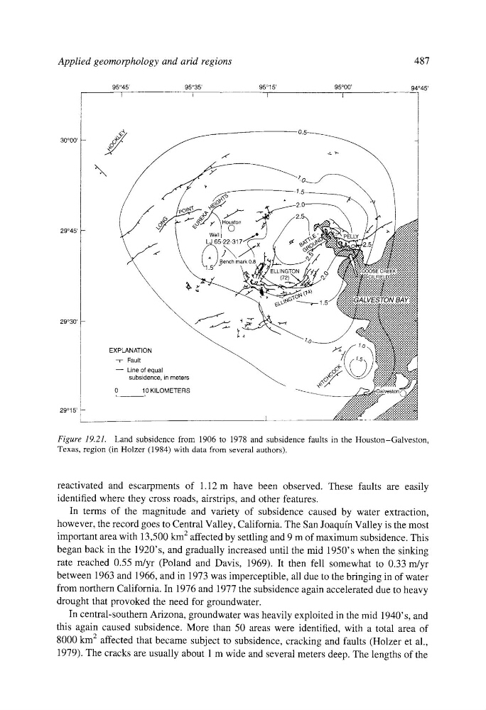
Figure 19.21. Land subsidence from 1906 to 1978 and subsidence faults in the Houston-Galveston,
Texas, region (in Holzer (1984) with data from several authors).
reactivated and escarpments of 1.12 m have been observed. These faults are easily
identified where they cross roads, airstrips, and other features.
In terms of the magnitude and variety of subsidence caused by water extraction,
however, the record goes to Central Valley, California. The San Joaquin Valley is the most
important area with 13,500 klTl 2 affected by settling and 9 m of maximum subsidence. This
began back in the 1920' s, and gradually increased until the mid 1950's when the sinking
rate reached 0.55 m/yr (Poland and Davis, 1969). It then fell somewhat to 0.33 m/yr
between 1963 and 1966, and in 1973 was imperceptible, all due to the bringing in of water
from northern California. In 1976 and 1977 the subsidence again accelerated due to heavy
drought that provoked the need for groundwater.
In central-southern Arizona, groundwater was heavily exploited in the mid 1940' s, and
this again caused subsidence. More than 50 areas were identified, with a total area of
8000 km 2 affected that became subject to subsidence, cracking and faults (Holzer et al.,
1979). The cracks are usually about 1 m wide and several meters deep. The lengths of the
487
30000 '
29o45 '
29o30 '
29~
95045 '
95035 '
95~
95o00 '
I
J
I
I
-
\J
sf i ~"-" Io
~'
/
U
1
, ,VVe., I o
...'_t__J i
\
_
' ~
LJ 65-22-317f('- x~.,
~
L I(
EXPLANATION
-r- Fault
-- Line of equal
subsidence, in meters
0
10 KILOMETERS
~7
-1.,
BAY
94045 '
Figure 19.21. Land subsidence from 1906 to 1978 and subsidence faults in the Houston-Galveston,
Texas, region (in Holzer (1984) with data from several authors).
reactivated and escarpments of 1.12 m have been observed. These faults are easily
identified where they cross roads, airstrips, and other features.
In terms of the magnitude and variety of subsidence caused by water extraction,
however, the record goes to Central Valley, California. The San Joaquin Valley is the most
important area with 13,500 klTl 2 affected by settling and 9 m of maximum subsidence. This
began back in the 1920' s, and gradually increased until the mid 1950's when the sinking
rate reached 0.55 m/yr (Poland and Davis, 1969). It then fell somewhat to 0.33 m/yr
between 1963 and 1966, and in 1973 was imperceptible, all due to the bringing in of water
from northern California. In 1976 and 1977 the subsidence again accelerated due to heavy
drought that provoked the need for groundwater.
In central-southern Arizona, groundwater was heavily exploited in the mid 1940' s, and
this again caused subsidence. More than 50 areas were identified, with a total area of
8000 km 2 affected that became subject to subsidence, cracking and faults (Holzer et al.,
1979). The cracks are usually about 1 m wide and several meters deep. The lengths of the