

486
Climatic Geomorphology
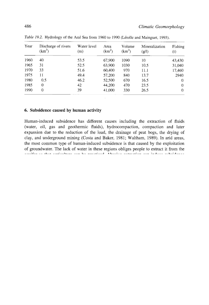
Table 19.2. Hydrology of the Aral Sea from 1960 to 1990 (L~tolle and Mainguet, 1993).
Year
Discharge of rivers
Water level
Area
Volume
Mineralization
Fishing
(km 3)
(m)
(km 2)
(km 3)
(g/l)
(t)
1960
40
53.5
67,900
1090
10
43,430
1965
31
52.5
63,900
1030
10.5
31,040
1970
33
51.6
60,400
970
11.1
17,460
1975
11
49.4
57,200
840
13.7
2940
1980
0.5
46.2
52,500
670
16.5
0
1985
0
42
44,200
470
23.5
0
1990
0
39
41,000
330
26.5
0
6. Subsidence caused by human activity
Human-induced subsidence has different causes including the extraction of fluids
(water, oil, gas and geothermic fluids), hydrocompaction, compaction and later
expansion due to the reduction of the load, the drainage of peat bogs, the drying of
clay, and underground mining (Costa and Baker, 1981; Waltham, 1989). In arid areas,
the most common type of human-induced subsidence is that caused by the exploitation
of groundwater. The lack of water in these regions obliges people to extract it from the
aquifer so that agriculture can be practiced. Abusive extraction can induce subsidence
when the hydrostatic pressure in the storage rock falls. This subsidence is more
frequent in non-consolidated Tertiary and Quaternary detrital deposits, formations in
which sand and clay alternate. With the extraction of water from the sands, the pressure
in the pores falls and the grains of sand have to support the overlying pressure. Sands
do not compact much, but the compressibility of clays is high, and this allows surface
subsidence (Marsden and Davis, 1967). This kind of subsidence generally affects large
areas, producing shallow depressions that cause damage to buildings and other features.
These endorheic areas of anthropic origin are sensitive to flooding, and if such
subsidence occurs on the coast the sea may invade the area. This happened in
Galveston Bay in Texas (Fig. 19.21), where residential areas were flooded (Coates,
1983, 1987).
In this same area, the extraction of groundwater has caused a wide sink hole and more
than 160 faults with a total length of some 500 km (Fig. 19.21) (Holzer, 1984). Of these, 86
have been historically active, and are probably the result of the reactivation of Tertiary
faults in the overlying Quaternary sediments. The groundwater is extracted mainly from
sand and clay beds of the Chicot Aquifer that form part of a thick sequence of nonconsolidated river and marine sediments. Pumping began at the end of the 19th century but
increased during the 1930's. The result was the generation of an area of subcircular
subsidence of about 12,200 km2; maximum sinkage was 2.5 m. Although the Goose Creek
oil field lies in the same area, its contribution to this subsidence appears to have been very
small.
The subsidence of this area is accompanied by faults at the centre and the flanks of the
depression, the density of faults being variable. Historically these faults have become
Climatic Geomorphology
Table 19.2. Hydrology of the Aral Sea from 1960 to 1990 (L~tolle and Mainguet, 1993).
Year
Discharge of rivers
Water level
Area
Volume
Mineralization
Fishing
(km 3)
(m)
(km 2)
(km 3)
(g/l)
(t)
1960
40
53.5
67,900
1090
10
43,430
1965
31
52.5
63,900
1030
10.5
31,040
1970
33
51.6
60,400
970
11.1
17,460
1975
11
49.4
57,200
840
13.7
2940
1980
0.5
46.2
52,500
670
16.5
0
1985
0
42
44,200
470
23.5
0
1990
0
39
41,000
330
26.5
0
6. Subsidence caused by human activity
Human-induced subsidence has different causes including the extraction of fluids
(water, oil, gas and geothermic fluids), hydrocompaction, compaction and later
expansion due to the reduction of the load, the drainage of peat bogs, the drying of
clay, and underground mining (Costa and Baker, 1981; Waltham, 1989). In arid areas,
the most common type of human-induced subsidence is that caused by the exploitation
of groundwater. The lack of water in these regions obliges people to extract it from the
aquifer so that agriculture can be practiced. Abusive extraction can induce subsidence
when the hydrostatic pressure in the storage rock falls. This subsidence is more
frequent in non-consolidated Tertiary and Quaternary detrital deposits, formations in
which sand and clay alternate. With the extraction of water from the sands, the pressure
in the pores falls and the grains of sand have to support the overlying pressure. Sands
do not compact much, but the compressibility of clays is high, and this allows surface
subsidence (Marsden and Davis, 1967). This kind of subsidence generally affects large
areas, producing shallow depressions that cause damage to buildings and other features.
These endorheic areas of anthropic origin are sensitive to flooding, and if such
subsidence occurs on the coast the sea may invade the area. This happened in
Galveston Bay in Texas (Fig. 19.21), where residential areas were flooded (Coates,
1983, 1987).
In this same area, the extraction of groundwater has caused a wide sink hole and more
than 160 faults with a total length of some 500 km (Fig. 19.21) (Holzer, 1984). Of these, 86
have been historically active, and are probably the result of the reactivation of Tertiary
faults in the overlying Quaternary sediments. The groundwater is extracted mainly from
sand and clay beds of the Chicot Aquifer that form part of a thick sequence of nonconsolidated river and marine sediments. Pumping began at the end of the 19th century but
increased during the 1930's. The result was the generation of an area of subcircular
subsidence of about 12,200 km2; maximum sinkage was 2.5 m. Although the Goose Creek
oil field lies in the same area, its contribution to this subsidence appears to have been very
small.
The subsidence of this area is accompanied by faults at the centre and the flanks of the
depression, the density of faults being variable. Historically these faults have become