

468
Climatic Geomorphology
N ,.~"'" '":-'.:
.. ~
Density of dolines
I
,,~
"'::-', ,"-1"
~. ,.
,. ,;...~,.,,
~
Dolines
"~,-' 2,'
'" ~'": "~2 ,'~ ~1---; ~] Irrigation ditches
'-/,
"
"i
""x''~" ~ Villamayor
,1-'> ~.' ...-.,
0
lo0'
"~""' " "
\'.....
"-,,~-:,
(a) 0 3000FEET
10
8
6
N/S
4
(b)
lib
o
woo
9
9
omwoom
9 9
so
9 mm
o
9
i
i
,i
,i
..t
i
t
0
400
800
1200
1600 METERS
,'--" :
~
!
I
I
t
I
I
I
0
1200
2400
3600
4800
FEET
Y~US
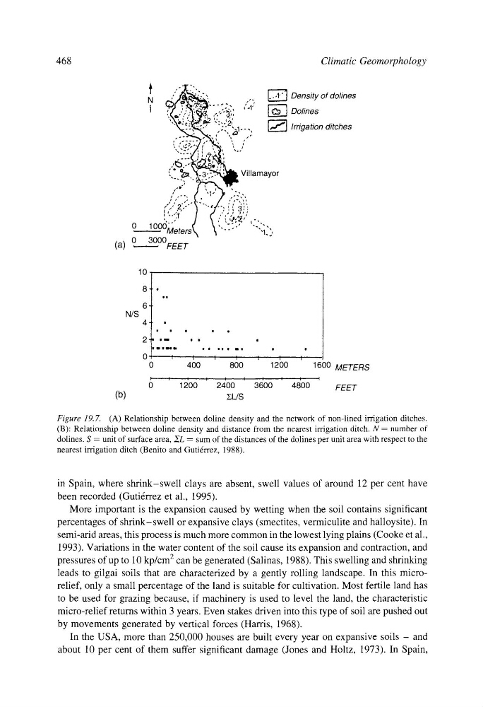
Figure 19.7. (A) Relationship between doline density and the network of non-lined irrigation ditches.
(B): Relationship between doline density and distance from the nearest irrigation ditch. N = number of
dolines. S = unit of surface area, ,~L -- sum of the distances of the dolines per unit area with respect to the
nearest irrigation ditch (Benito and Guti6rrez, 1988).
in Spain, where shrink-swell clays are absent, swell values of around 12 per cent have
been recorded (Guti4rrez et al., 1995).
More important is the expansion caused by wetting when the soil contains significant
percentages of shrink-swell or expansive clays (smectites, vermiculite and halloysite). In
semi-arid areas, this process is much more common in the lowest lying plains (Cooke et al.,
1993). Variations in the water content of the soil cause its expansion and contraction, and
pressures of up to 10 kp/cm 2 can be generated (Salinas, 1988). This swelling and shrinking
leads to gilgai soils that are characterized by a gently rolling landscape. In this microrelief, only a small percentage of the land is suitable for cultivation. Most fertile land has
to be used for grazing because, if machinery is used to level the land, the characteristic
micro-relief returns within 3 years. Even stakes driven into this type of soil are pushed out
by movements generated by vertical forces (Harris, 1968).
In the USA, more than 250,000 houses are built every year on expansive soils - and
about 10 per cent of them suffer significant damage (Jones and Holtz, 1973). In Spain,
Climatic Geomorphology
N ,.~"'" '":-'.:
.. ~
Density of dolines
I
,,~
"'::-', ,"-1"
~. ,.
,. ,;...~,.,,
~
Dolines
"~,-' 2,'
'" ~'": "~2 ,'~ ~1---; ~] Irrigation ditches
'-/,
"
"i
""x''~" ~ Villamayor
,1-'> ~.' ...-.,
0
lo0'
"~""' " "
\'.....
"-,,~-:,
(a) 0 3000FEET
10
8
6
N/S
4
(b)
lib
o
woo
9
9
omwoom
9 9
so
9 mm
o
9
i
i
,i
,i
..t
i
t
0
400
800
1200
1600 METERS
,'--" :
~
!
I
I
t
I
I
I
0
1200
2400
3600
4800
FEET
Y~US
Figure 19.7. (A) Relationship between doline density and the network of non-lined irrigation ditches.
(B): Relationship between doline density and distance from the nearest irrigation ditch. N = number of
dolines. S = unit of surface area, ,~L -- sum of the distances of the dolines per unit area with respect to the
nearest irrigation ditch (Benito and Guti6rrez, 1988).
in Spain, where shrink-swell clays are absent, swell values of around 12 per cent have
been recorded (Guti4rrez et al., 1995).
More important is the expansion caused by wetting when the soil contains significant
percentages of shrink-swell or expansive clays (smectites, vermiculite and halloysite). In
semi-arid areas, this process is much more common in the lowest lying plains (Cooke et al.,
1993). Variations in the water content of the soil cause its expansion and contraction, and
pressures of up to 10 kp/cm 2 can be generated (Salinas, 1988). This swelling and shrinking
leads to gilgai soils that are characterized by a gently rolling landscape. In this microrelief, only a small percentage of the land is suitable for cultivation. Most fertile land has
to be used for grazing because, if machinery is used to level the land, the characteristic
micro-relief returns within 3 years. Even stakes driven into this type of soil are pushed out
by movements generated by vertical forces (Harris, 1968).
In the USA, more than 250,000 houses are built every year on expansive soils - and
about 10 per cent of them suffer significant damage (Jones and Holtz, 1973). In Spain,