

296
Climatic Geomorphology
In the river courses of arid regions a part of the flow is lost by infiltration and evaporation. Floods in small ephemeral streams are lost over short distances, whereas in larger
rivers water is lost gradually, mainly through evaporation, with a clear reduction in
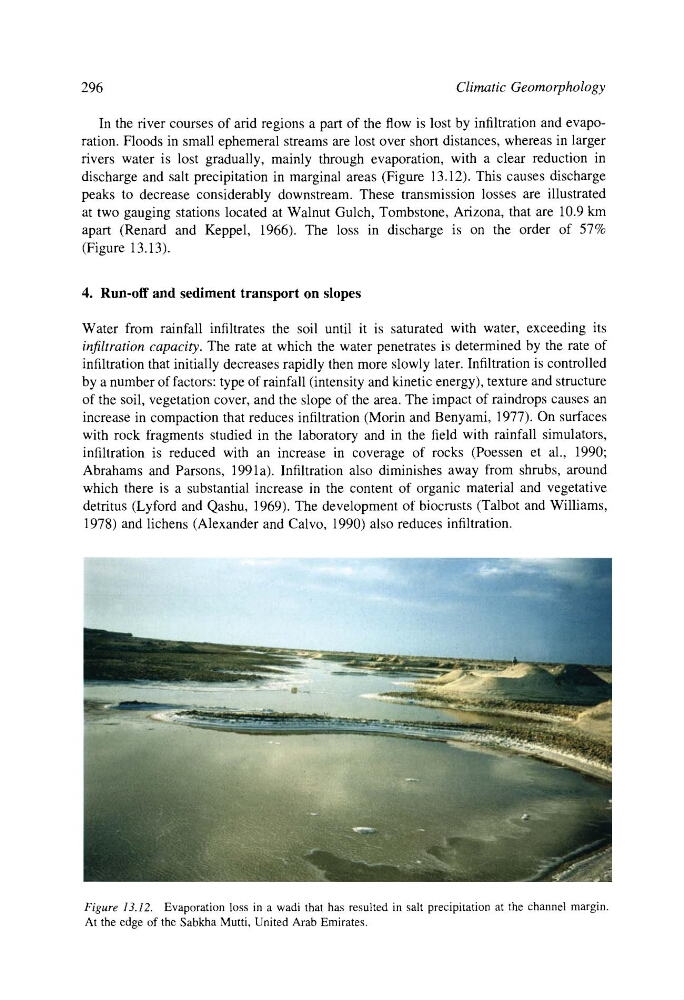
discharge and salt precipitation in marginal areas (Figure 13.12). This causes discharge
peaks to decrease considerably downstream. These transmission losses are illustrated
at two gauging stations located at Walnut Gulch, Tombstone, Arizona, that are 10.9 km
apart (Renard and Keppel, 1966). The loss in discharge is on the order of 57%
(Figure 13.13).
4. Run-off and sediment transport on slopes
Water from rainfall infiltrates the soil until it is saturated with water, exceeding its
infiltration capacity. The rate at which the water penetrates is determined by the rate of
infiltration that initially decreases rapidly then more slowly later. Infiltration is controlled
by a number of factors: type of rainfall (intensity and kinetic energy), texture and structure
of the soil, vegetation cover, and the slope of the area. The impact of raindrops causes an
increase in compaction that reduces infiltration (Morin and Benyami, 1977). On surfaces
with rock fragments studied in the laboratory and in the field with rainfall simulators,
infiltration is reduced with an increase in coverage of rocks (Poessen et al., 1990;
Abrahams and Parsons, 1991a). Infiltration also diminishes away from shrubs, around
which there is a substantial increase in the content of organic material and vegetative
detritus (Lyford and Qashu, 1969). The development of biocrusts (Talbot and Williams,
1978) and lichens (Alexander and Calvo, 1990) also reduces infiltration.
Figure 13.12. Evaporation loss in a wadi that has resulted in salt precipitation at the channel margin.
At the edge of the Sabkha Mutti, United Arab Emirates.
Climatic Geomorphology
In the river courses of arid regions a part of the flow is lost by infiltration and evaporation. Floods in small ephemeral streams are lost over short distances, whereas in larger
rivers water is lost gradually, mainly through evaporation, with a clear reduction in
discharge and salt precipitation in marginal areas (Figure 13.12). This causes discharge
peaks to decrease considerably downstream. These transmission losses are illustrated
at two gauging stations located at Walnut Gulch, Tombstone, Arizona, that are 10.9 km
apart (Renard and Keppel, 1966). The loss in discharge is on the order of 57%
(Figure 13.13).
4. Run-off and sediment transport on slopes
Water from rainfall infiltrates the soil until it is saturated with water, exceeding its
infiltration capacity. The rate at which the water penetrates is determined by the rate of
infiltration that initially decreases rapidly then more slowly later. Infiltration is controlled
by a number of factors: type of rainfall (intensity and kinetic energy), texture and structure
of the soil, vegetation cover, and the slope of the area. The impact of raindrops causes an
increase in compaction that reduces infiltration (Morin and Benyami, 1977). On surfaces
with rock fragments studied in the laboratory and in the field with rainfall simulators,
infiltration is reduced with an increase in coverage of rocks (Poessen et al., 1990;
Abrahams and Parsons, 1991a). Infiltration also diminishes away from shrubs, around
which there is a substantial increase in the content of organic material and vegetative
detritus (Lyford and Qashu, 1969). The development of biocrusts (Talbot and Williams,
1978) and lichens (Alexander and Calvo, 1990) also reduces infiltration.
Figure 13.12. Evaporation loss in a wadi that has resulted in salt precipitation at the channel margin.
At the edge of the Sabkha Mutti, United Arab Emirates.