

290
Climatic Geomorphology
FORMER COURSES OF
R. SARASWATHI IN
WESTERN THAR
28~
SUKKUR
2, "~
"o .... '
I I i I
'1
I
I
0
AN U PGARH ~/'..=~=-- -- =,~...
.
.~.
. at... ~- ~
-- f
~
#
.. ~," .<,/
SAKHIo,,~z ~
/
,
.:/
I"
'0'
.o"
/
"t
1t
~
/~ "~
J
" TAN CQ.T"
9 -~-_]HOTARU kx
BAP~
AHGA~.~~
POKARAN ~
SCALE
.y../
9
I
JAISALMER
MIYAJLAR
/
.:.~;~" -BARMER 9
'li UMARKOT
RANN OF KACHCHH
0 40 80 120 160 200
l
i
1
I
n
i
KILOMETRES
73O0'E
1
I
~~ o_~, oo
r- -
~.
kms
t 9 SALMEI~~
69O0'E
71~ '
~]
EXlSTINGSTREAMS
~
FORMERSTREAMS ~
SALTMARSH
I,- ;q ~"~E~T OF
~ ~
S~ ''~
E
~SST~E~S U~ OE~ T ~
~
~
T.~ ~ESTE~,.~ T
~
~L~~ FLOW DIRECTION OF FORMER STREAMS
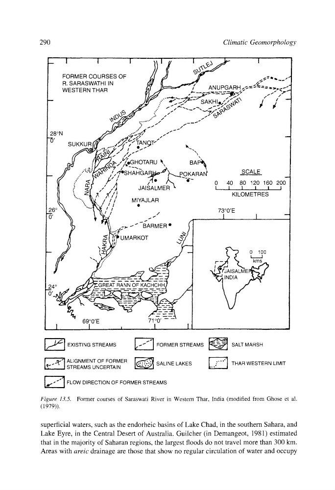
Figure 13.5. Former courses of Saraswati River in Western Thar, India (modified from Ghose et al.
(1979)).
superficial waters, such as the endorheic basins of Lake Chad, in the southern Sahara, and
Lake Eyre, in the Central Desert of Australia. Guilcher (in Demangeot, 1981) estimated
that in the majority of Saharan regions, the largest floods do not travel more than 300 km.
Areas with areic drainage are those that show no regular circulation of water and occupy
Climatic Geomorphology
FORMER COURSES OF
R. SARASWATHI IN
WESTERN THAR
28~
SUKKUR
2, "~
"o .... '
I I i I
'1
I
I
0
AN U PGARH ~/'..=~=-- -- =,~...
.
.~.
. at... ~- ~
-- f
~
#
.. ~," .<,/
SAKHIo,,~z ~
/
,
.:/
I"
'0'
.o"
/
"t
1t
~
/~ "~
J
" TAN CQ.T"
9 -~-_]HOTARU kx
BAP~
AHGA~.~~
POKARAN ~
SCALE
.y../
9
I
JAISALMER
MIYAJLAR
/
.:.~;~" -BARMER 9
'li UMARKOT
RANN OF KACHCHH
0 40 80 120 160 200
l
i
1
I
n
i
KILOMETRES
73O0'E
1
I
~~ o_~, oo
r- -
~.
kms
t 9 SALMEI~~
69O0'E
71~ '
~]
EXlSTINGSTREAMS
~
FORMERSTREAMS ~
SALTMARSH
I,- ;q ~"~E~T OF
~ ~
S~ ''~
E
~SST~E~S U~ OE~ T ~
~
~
T.~ ~ESTE~,.~ T
~
~L~~ FLOW DIRECTION OF FORMER STREAMS
Figure 13.5. Former courses of Saraswati River in Western Thar, India (modified from Ghose et al.
(1979)).
superficial waters, such as the endorheic basins of Lake Chad, in the southern Sahara, and
Lake Eyre, in the Central Desert of Australia. Guilcher (in Demangeot, 1981) estimated
that in the majority of Saharan regions, the largest floods do not travel more than 300 km.
Areas with areic drainage are those that show no regular circulation of water and occupy