

1 O0
Climatic Geomorphology
most extensive morphologies is that of the till sheets, which are also known as ground
moraines. They are large plains covered with till, whose depth varies between half a metre
and tens of metres, and they can cover a surface area of thousands of km 2 (Kemmis, 1989).
They cover large areas of the European and North American plains that were occupied by
ice-sheets. In detail, their topography is very irregular, with rock substrate outcrops, small
hills and lakes, and lobate forms of the moraines. Some till sections show intercalations
of gravels and sands, an indication of alternating glacial and fluvioglacial environments.
The thickness is variable and the existence of an extensive thick accumulation is interpreted as a stagnation of the glacier, whereas a thin coveting can indicate a fast ice retreat.
At present these till sheets are being destroyed by fluvial erosion, and incision enables
recognition of sections of the deposit. These accumulations are the result of different
advances and retreats of the Pleistocene ice sheets, and consequently their sedimentological study provides very valuable data on the Quaternary geology of these regions.
Other subglacial forms show a parallel alignment to the ice flow. The fluted moraines
are an alternation of rectilinear ridges and furrows over the till, located in the borders of
retreating glaciers. Their length is of tens or hundreds of metres and their heights do not
generally exceed 5 m. They originate in areas sheltered by large blocks deposited in the
ice bed, which create an area of low pressures downstream (Boulton, 1976; Gordon et al.,
1992). The longitudinal profile of the forms is similar to that of elongate drumlins and
they are considered by some authors to be linear, very narrow drumlins (Prest, 1968).
One of the unsolved problems of interpretation is the regularity of the spacing between
the ridges in some moraines.
Drumlins are elongate hills with a major axis parallel to the ice movement. They have an
inverted spoon or semi-ellipsoid form. Their length varies between 10 and 3000 m, their
height is between 5 and 50 m, and their width is variable according to the degree of length
(Menzies, 1979; Chorley et al., 1984). Their longitudinal profile shows a greater gradient
upstream, coinciding with the greater height, whereas downstream it develops a pointed
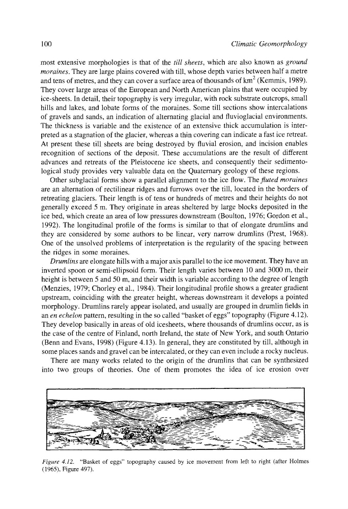
morphology. Drumlins rarely appear isolated, and usually are grouped in drumlin fields in
an en echelon pattern, resulting in the so called "basket of eggs" topography (Figure 4.12).
They develop basically in areas of old icesheets, where thousands of drumlins occur, as is
the case of the centre of Finland, north Ireland, the state of New York, and south Ontario
(Benn and Evans, 1998) (Figure 4.13). In general, they are constituted by till, although in
some places sands and gravel can be intercalated, or they can even include a rocky nucleus.
There are many works related to the origin of the drumlins that can be synthesized
into two groups of theories. One of them promotes the idea of ice erosion over
-
-
Figure 4.12. "Basket of eggs" topography caused by ice movement from left to right (after Holmes
(1965), Figure 497).
Climatic Geomorphology
most extensive morphologies is that of the till sheets, which are also known as ground
moraines. They are large plains covered with till, whose depth varies between half a metre
and tens of metres, and they can cover a surface area of thousands of km 2 (Kemmis, 1989).
They cover large areas of the European and North American plains that were occupied by
ice-sheets. In detail, their topography is very irregular, with rock substrate outcrops, small
hills and lakes, and lobate forms of the moraines. Some till sections show intercalations
of gravels and sands, an indication of alternating glacial and fluvioglacial environments.
The thickness is variable and the existence of an extensive thick accumulation is interpreted as a stagnation of the glacier, whereas a thin coveting can indicate a fast ice retreat.
At present these till sheets are being destroyed by fluvial erosion, and incision enables
recognition of sections of the deposit. These accumulations are the result of different
advances and retreats of the Pleistocene ice sheets, and consequently their sedimentological study provides very valuable data on the Quaternary geology of these regions.
Other subglacial forms show a parallel alignment to the ice flow. The fluted moraines
are an alternation of rectilinear ridges and furrows over the till, located in the borders of
retreating glaciers. Their length is of tens or hundreds of metres and their heights do not
generally exceed 5 m. They originate in areas sheltered by large blocks deposited in the
ice bed, which create an area of low pressures downstream (Boulton, 1976; Gordon et al.,
1992). The longitudinal profile of the forms is similar to that of elongate drumlins and
they are considered by some authors to be linear, very narrow drumlins (Prest, 1968).
One of the unsolved problems of interpretation is the regularity of the spacing between
the ridges in some moraines.
Drumlins are elongate hills with a major axis parallel to the ice movement. They have an
inverted spoon or semi-ellipsoid form. Their length varies between 10 and 3000 m, their
height is between 5 and 50 m, and their width is variable according to the degree of length
(Menzies, 1979; Chorley et al., 1984). Their longitudinal profile shows a greater gradient
upstream, coinciding with the greater height, whereas downstream it develops a pointed
morphology. Drumlins rarely appear isolated, and usually are grouped in drumlin fields in
an en echelon pattern, resulting in the so called "basket of eggs" topography (Figure 4.12).
They develop basically in areas of old icesheets, where thousands of drumlins occur, as is
the case of the centre of Finland, north Ireland, the state of New York, and south Ontario
(Benn and Evans, 1998) (Figure 4.13). In general, they are constituted by till, although in
some places sands and gravel can be intercalated, or they can even include a rocky nucleus.
There are many works related to the origin of the drumlins that can be synthesized
into two groups of theories. One of them promotes the idea of ice erosion over
-
-
Figure 4.12. "Basket of eggs" topography caused by ice movement from left to right (after Holmes
(1965), Figure 497).