

Résumé
186
- From Jean Bart to Boudouaou el bahri
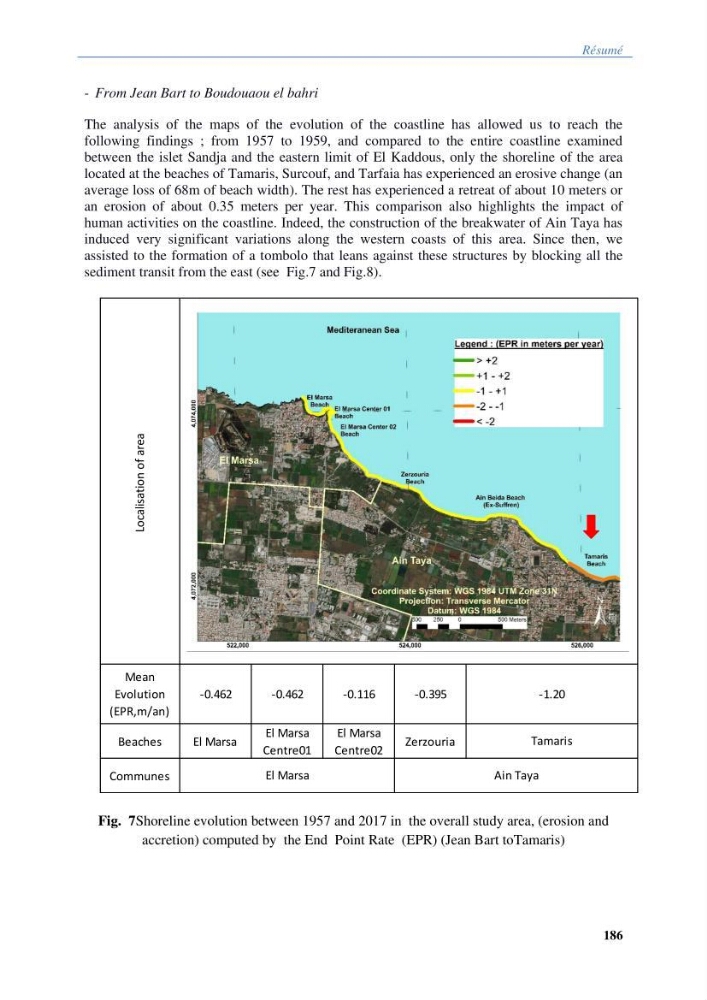
The analysis of the maps of the evolution of the coastline has allowed us to reach the
following findings ; from 1957 to 1959, and compared to the entire coastline examined
between the islet Sandja and the eastern limit of El Kaddous, only the shoreline of the area
located at the beaches of Tamaris, Surcouf, and Tarfaia has experienced an erosive change (an
average loss of 68m of beach width). The rest has experienced a retreat of about 10 meters or
an erosion of about 0.35 meters per year. This comparison also highlights the impact of
human activities on the coastline. Indeed, the construction of the breakwater of Ain Taya has
induced very significant variations along the western coasts of this area. Since then, we
assisted to the formation of a tombolo that leans against these structures by blocking all the
sediment transit from the east (see Fig.7 and Fig.8).
Fig. 7Shoreline evolution between 1957 and 2017 in the overall study area, (erosion and
accretion) computed by the End Point Rate (EPR) (Jean Bart toTamaris)
Localisation of area
Mean
Evolution
(EPR,m/an)
-0.462
-0.462
-0.116
-0.395
Beaches
El Marsa
El Marsa
Centre01
El Marsa
Centre02
Zerzouria
Communes
Shoreline evolution between 1957 and 2017 in the overall study area, (erosion and accretion)
computed by the End Point Rate (EPR) method.
-1.20
Tamaris
El Marsa
Ain Taya
186
- From Jean Bart to Boudouaou el bahri
The analysis of the maps of the evolution of the coastline has allowed us to reach the
following findings ; from 1957 to 1959, and compared to the entire coastline examined
between the islet Sandja and the eastern limit of El Kaddous, only the shoreline of the area
located at the beaches of Tamaris, Surcouf, and Tarfaia has experienced an erosive change (an
average loss of 68m of beach width). The rest has experienced a retreat of about 10 meters or
an erosion of about 0.35 meters per year. This comparison also highlights the impact of
human activities on the coastline. Indeed, the construction of the breakwater of Ain Taya has
induced very significant variations along the western coasts of this area. Since then, we
assisted to the formation of a tombolo that leans against these structures by blocking all the
sediment transit from the east (see Fig.7 and Fig.8).
Fig. 7Shoreline evolution between 1957 and 2017 in the overall study area, (erosion and
accretion) computed by the End Point Rate (EPR) (Jean Bart toTamaris)
Localisation of area
Mean
Evolution
(EPR,m/an)
-0.462
-0.462
-0.116
-0.395
Beaches
El Marsa
El Marsa
Centre01
El Marsa
Centre02
Zerzouria
Communes
Shoreline evolution between 1957 and 2017 in the overall study area, (erosion and accretion)
computed by the End Point Rate (EPR) method.
-1.20
Tamaris
El Marsa
Ain Taya