

Résumé
187
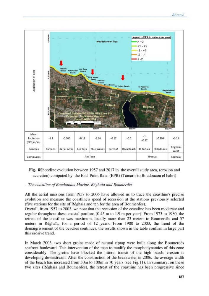
Fig. 8Shoreline evolution between 1957 and 2017 in the overall study area, (erosion and
accretion) computed by the End Point Rate (EPR) (Tamaris to Boudouaou el bahri)
- The coastline of Boudouaou Marine, Réghaïa and Boumerdès
All the aerial missions from 1957 to 2006 have allowed us to trace the coastline's precise
evolution and measure the coastline's speed of recession at the stations previously selected
(five stations for the site of Réghaïa and ten for the area of Boumerdès).
Overall, from 1957 to 2003, we note that the recession of the coastline has been moderate and
regular throughout these coastal portions (0.45 m to 1.9 m per year). From 1973 to 1980, the
retreat of the coastline was maximum, locally more than 23 meters to Boumerdès and 57
meters in Réghaïa, for a period of 12 years. From 1980 to 2003, the trend of the
demaigrissement of the beaches continues, the results shown in the table confirm in large part
this erosive trend.
In March 2003, two short groins made of natural riprap were built along the Boumerdès
seafront boulevard. This intervention of the man to modify the morphodynamics of this zone
considerably. The groins have blocked the littoral transit of the high beach; erosion is
developing downstream. After the construction of the breakwater in 2006, the average width
of the beach has increased from 50m to 100m in 70 years (see Fig.11). In summary, on these
two sites (Réghaïa and Boumerdès), the retreat of the coastline has been progressive since
Localisation of area
Mean
Evolution
(EPR,m/an)
-1.2
-0.166
-0.18
-1.66
-0.17
-0.5
-1
-0.17
-0.166
+0.15
Beaches
Tamaris Kef el Arrar Ain Taya Blue Waves Surcouf Deca Beach El Tarfaia El Kaddous
Reghaia
West
Communes
Reghaia
Shoreline evolution between 1957 and 2017 in the overall study area, (erosion and accretion) computed by the End Point Rate
(EPR) method.
Ain Taya
Hraoua
187
Fig. 8Shoreline evolution between 1957 and 2017 in the overall study area, (erosion and
accretion) computed by the End Point Rate (EPR) (Tamaris to Boudouaou el bahri)
- The coastline of Boudouaou Marine, Réghaïa and Boumerdès
All the aerial missions from 1957 to 2006 have allowed us to trace the coastline's precise
evolution and measure the coastline's speed of recession at the stations previously selected
(five stations for the site of Réghaïa and ten for the area of Boumerdès).
Overall, from 1957 to 2003, we note that the recession of the coastline has been moderate and
regular throughout these coastal portions (0.45 m to 1.9 m per year). From 1973 to 1980, the
retreat of the coastline was maximum, locally more than 23 meters to Boumerdès and 57
meters in Réghaïa, for a period of 12 years. From 1980 to 2003, the trend of the
demaigrissement of the beaches continues, the results shown in the table confirm in large part
this erosive trend.
In March 2003, two short groins made of natural riprap were built along the Boumerdès
seafront boulevard. This intervention of the man to modify the morphodynamics of this zone
considerably. The groins have blocked the littoral transit of the high beach; erosion is
developing downstream. After the construction of the breakwater in 2006, the average width
of the beach has increased from 50m to 100m in 70 years (see Fig.11). In summary, on these
two sites (Réghaïa and Boumerdès), the retreat of the coastline has been progressive since
Localisation of area
Mean
Evolution
(EPR,m/an)
-1.2
-0.166
-0.18
-1.66
-0.17
-0.5
-1
-0.17
-0.166
+0.15
Beaches
Tamaris Kef el Arrar Ain Taya Blue Waves Surcouf Deca Beach El Tarfaia El Kaddous
Reghaia
West
Communes
Reghaia
Shoreline evolution between 1957 and 2017 in the overall study area, (erosion and accretion) computed by the End Point Rate
(EPR) method.
Ain Taya
Hraoua