

Résumé
181
Meteorological and oceanographic factors are essential for understanding sediment transfer
along the coast and its consequences on beach nourishment or erosion. The Mediterranean
climate is characterized by four contrasting seasons, mild winter, spring, and autumn are
sometimes very rainy, and dry and hot summer.
The narrowness of its plateau continental characterizes the bay: 1.5 km (Leclaire 1972), it
narrows at the level of Mount Thénia where tectonics is active, its width does not exceed 3
km, moreover, in front of the low area of the wadi Isser, the width of the shelf can reach 15
km (Fig.5) , we find :
- A succession of submarine dunes reaching the area of Cap Blanc and the Black Rock: under
the effect of the swell, the sediments of large submarine dune clusters are found only at the
level of Cap Djennet and Cap Blanc (hydraulic dunes).
- A rocky plain surrounding the peninsula of Cape Matifou appears in the form of shreds
forming the plateau of Agueli Island and Sanja Island.
- The rest of the bottom is made up of loose sediments with sometimes sparse vegetation.
The continental slope is intensely chiseled by a network of canyons (submarine valley of
Zemmouri), which disturbs the plateau's regularity and the evolution of the coastline.
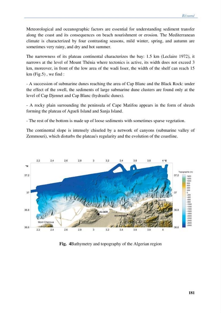
Fig. 4Bathymetry and topography of the Algerian region
181
Meteorological and oceanographic factors are essential for understanding sediment transfer
along the coast and its consequences on beach nourishment or erosion. The Mediterranean
climate is characterized by four contrasting seasons, mild winter, spring, and autumn are
sometimes very rainy, and dry and hot summer.
The narrowness of its plateau continental characterizes the bay: 1.5 km (Leclaire 1972), it
narrows at the level of Mount Thénia where tectonics is active, its width does not exceed 3
km, moreover, in front of the low area of the wadi Isser, the width of the shelf can reach 15
km (Fig.5) , we find :
- A succession of submarine dunes reaching the area of Cap Blanc and the Black Rock: under
the effect of the swell, the sediments of large submarine dune clusters are found only at the
level of Cap Djennet and Cap Blanc (hydraulic dunes).
- A rocky plain surrounding the peninsula of Cape Matifou appears in the form of shreds
forming the plateau of Agueli Island and Sanja Island.
- The rest of the bottom is made up of loose sediments with sometimes sparse vegetation.
The continental slope is intensely chiseled by a network of canyons (submarine valley of
Zemmouri), which disturbs the plateau's regularity and the evolution of the coastline.
Fig. 4Bathymetry and topography of the Algerian region