

258
E. Salameh et al.
the Jabal Druz area. The upper wadi course is oriented in
a south easterly direction, gradually turning south westerly,
and then westerly to discharge into the Azraq Oasis. The
wadi is intermittent, discharging flood and snow melt water.
Rajil dam was constructed on the wadi in the 1990s to collect the flood waters with the purpose of providing cattle
watering and artificial groundwater recharge (Ass’ad and
Abdualla 2010)
18.4.2 Climate
The climate of the dam surroundings is characterized by hot
dry summers and moderately wet cool winters and can be
classified as arid. The upper reaches of the catchment (Jabel
Drouz area) enjoy a Mediterranean climate where rainfall
averages 450 mm/yr decreasing exponentially to 80 mm/yr
in the Rajil dam and Azraq area.
The potential evaporation rate in the dam surroundings
is 2100 mm/yr, and the average relative humidity ranges
from 52 to 62 % during summer and from 70 to 80 % during winter. The mean annual temperature is 19 °C. August is
the hottest month with a monthly daily average temperature
of 28 °C. January is the coldest month with a monthly daily
average of 5 °C. Winds are moderate, easterly in summer
and westerly in winter. The mean annual sunshine duration
per day was 9 h in winter which was increased to 12 h in
summer.
18.4.3 Runoff
Like all other wadis in the Azraq basin, Wadi Rajil is not
gauged. The wadi bottom slope decreases from Jabal Drouz
with a slope of 15 to 5–15 % along the middle wadi reaches
and to 3–5 % along the lower reaches. Evaluating the runoff/precipitation ratio for the type of climate, landuse, topography, and geological conditions results in a ratio of
1.2 % and in an average annual flood flow discharge of
3.85 %.
18.4.4 Rock Types
The dam site and surroundings are covered by basalts underlain
by chalky limestone with some chert beds of the Muwaqqar
Tertiary Formation. Parts of the reservoir lake are covered by
alluvial deposits of basalt, gravel, sand, silt, and clay.
18.4.5 Chemistry of the Dam Water
Within the Rajil dam catchment area, land use is restricted
to some cattle grazing spread over the catchment area. The
wastes of the sporadic human activities and those of grazing
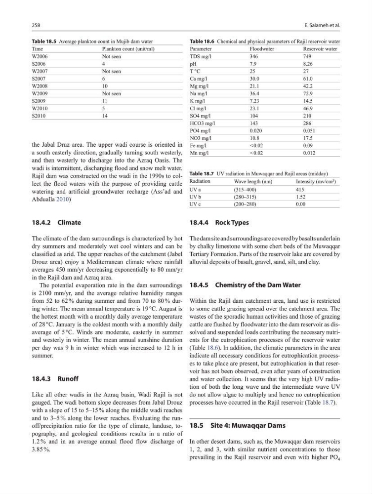
cattle are flushed by floodwater into the dam reservoir as dissolved and suspended loads contributing the necessary nutrients for the eutrophication processes of the reservoir water
(Table 18.6). In addition, the climatic parameters in the area
indicate all necessary conditions for eutrophication processes to take place are present, but eutrophication in that reservoir has not been observed, even after years of construction
and water collection. It seems that the very high UV radiation of both the long wave and the intermediate wave UV
do not allow algae to multiply and hence no eutrophication
processes have occurred in the Rajil reservoir (Table 18.7).
18.5 Site 4: Muwaqqar Dams
In other desert dams, such as, the Muwaqqar dam reservoirs
1, 2, and 3, with similar nutrient concentrations to those
prevailing in the Rajil reservoir and even with higher PO 4
Table 18.5 Average plankton count in Mujib dam water
Time
Plankton count (unit/ml)
W2006
Not seen
S2006
4
W2007
Not seen
S2007
6
W2008
10
W2009
Not seen
S2009
11
W2010
5
S2010
14
Table 18.6 Chemical and physical parameters of Rajil reservoir water
Parameter
Floodwater
Reservoir water
TDS mg/l
346
749
pH
7.9
8.26
T °C
25
27
Ca mg/l
30.0
61.0
Mg mg/l
21.1
42.2
Na mg/l
36.4
72.9
K mg/l
7.23
14.5
Cl mg/l
23.1
46.9
SO4 mg/l
104
210
HCO3 mg/l
143
286
PO4 mg/l
0.020
0.051
NO3 mg/l
10.8
17.5
Fe mg/l
< 0.02
0.09
Mn mg/l
< 0.02
0.012
Table 18.7 UV radiation in Muwaqqar and Rajil areas (midday)
Radiation
Wave length (nm)
Intensity (mv/cm²)
UV a
(315–400)
415
UV b
(280–315)
1.52
UV c
(200–280)
0.00
E. Salameh et al.
the Jabal Druz area. The upper wadi course is oriented in
a south easterly direction, gradually turning south westerly,
and then westerly to discharge into the Azraq Oasis. The
wadi is intermittent, discharging flood and snow melt water.
Rajil dam was constructed on the wadi in the 1990s to collect the flood waters with the purpose of providing cattle
watering and artificial groundwater recharge (Ass’ad and
Abdualla 2010)
18.4.2 Climate
The climate of the dam surroundings is characterized by hot
dry summers and moderately wet cool winters and can be
classified as arid. The upper reaches of the catchment (Jabel
Drouz area) enjoy a Mediterranean climate where rainfall
averages 450 mm/yr decreasing exponentially to 80 mm/yr
in the Rajil dam and Azraq area.
The potential evaporation rate in the dam surroundings
is 2100 mm/yr, and the average relative humidity ranges
from 52 to 62 % during summer and from 70 to 80 % during winter. The mean annual temperature is 19 °C. August is
the hottest month with a monthly daily average temperature
of 28 °C. January is the coldest month with a monthly daily
average of 5 °C. Winds are moderate, easterly in summer
and westerly in winter. The mean annual sunshine duration
per day was 9 h in winter which was increased to 12 h in
summer.
18.4.3 Runoff
Like all other wadis in the Azraq basin, Wadi Rajil is not
gauged. The wadi bottom slope decreases from Jabal Drouz
with a slope of 15 to 5–15 % along the middle wadi reaches
and to 3–5 % along the lower reaches. Evaluating the runoff/precipitation ratio for the type of climate, landuse, topography, and geological conditions results in a ratio of
1.2 % and in an average annual flood flow discharge of
3.85 %.
18.4.4 Rock Types
The dam site and surroundings are covered by basalts underlain
by chalky limestone with some chert beds of the Muwaqqar
Tertiary Formation. Parts of the reservoir lake are covered by
alluvial deposits of basalt, gravel, sand, silt, and clay.
18.4.5 Chemistry of the Dam Water
Within the Rajil dam catchment area, land use is restricted
to some cattle grazing spread over the catchment area. The
wastes of the sporadic human activities and those of grazing
cattle are flushed by floodwater into the dam reservoir as dissolved and suspended loads contributing the necessary nutrients for the eutrophication processes of the reservoir water
(Table 18.6). In addition, the climatic parameters in the area
indicate all necessary conditions for eutrophication processes to take place are present, but eutrophication in that reservoir has not been observed, even after years of construction
and water collection. It seems that the very high UV radiation of both the long wave and the intermediate wave UV
do not allow algae to multiply and hence no eutrophication
processes have occurred in the Rajil reservoir (Table 18.7).
18.5 Site 4: Muwaqqar Dams
In other desert dams, such as, the Muwaqqar dam reservoirs
1, 2, and 3, with similar nutrient concentrations to those
prevailing in the Rajil reservoir and even with higher PO 4
Table 18.5 Average plankton count in Mujib dam water
Time
Plankton count (unit/ml)
W2006
Not seen
S2006
4
W2007
Not seen
S2007
6
W2008
10
W2009
Not seen
S2009
11
W2010
5
S2010
14
Table 18.6 Chemical and physical parameters of Rajil reservoir water
Parameter
Floodwater
Reservoir water
TDS mg/l
346
749
pH
7.9
8.26
T °C
25
27
Ca mg/l
30.0
61.0
Mg mg/l
21.1
42.2
Na mg/l
36.4
72.9
K mg/l
7.23
14.5
Cl mg/l
23.1
46.9
SO4 mg/l
104
210
HCO3 mg/l
143
286
PO4 mg/l
0.020
0.051
NO3 mg/l
10.8
17.5
Fe mg/l
< 0.02
0.09
Mn mg/l
< 0.02
0.012
Table 18.7 UV radiation in Muwaqqar and Rajil areas (midday)
Radiation
Wave length (nm)
Intensity (mv/cm²)
UV a
(315–400)
415
UV b
(280–315)
1.52
UV c
(200–280)
0.00