

182
7: Hua-mei Chen, Pramod K. Varshney
a
b
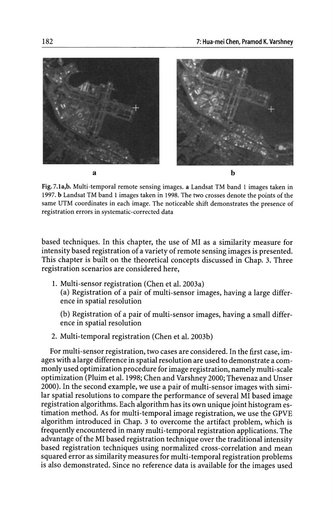
Fig.7.1a,b. Multi-temporal remote sensing images. a Landsat TM band 1 images taken in
1997. b Landsat TM band 1 images taken in 1998. The two crosses denote the points of the
same UTM coordinates in each image. The noticeable shift demonstrates the presence of
registration errors in systematic-corrected data
based techniques. In this chapter, the use of MI as a similarity measure for
intensity based registration of a variety of remote sensing images is presented.
This chapter is built on the theoretical concepts discussed in Chap. 3. Three
registration scenarios are considered here,
1. Multi-sensor registration (Chen et al. 2003a)
(a) Registration of a pair of multi-sensor images, having a large difference in spatial resolution
(b) Registration of a pair of multi-sensor images, having a small difference in spatial resolution
2. Multi-temporal registration (Chen et al. 2003b)
For multi-sensor registration, two cases are considered. In the first case, images with a large difference in spatial resolution are used to demonstrate a commonly used optimization procedure for image registration, namely multi-scale
optimization (Pluim et al. 1998; Chen and Varshney 2000; Thevenaz and Unser
2000). In the second example, we use a pair of multi-sensor images with similar spatial resolutions to compare the performance of several MI based image
registration algorithms. Each algorithm has its own unique joint histogram estimation method. As for multi-temporal image registration, we use the GPVE
algorithm introduced in Chap. 3 to overcome the artifact problem, which is
frequently encountered in many multi-temporal registration applications. The
advantage of the MI based registration technique over the traditional intensity
based registration techniques using normalized cross-correlation and mean
squared error as similarity measures for multi-temporal registration problems
is also demonstrated. Since no reference data is available for the images used
7: Hua-mei Chen, Pramod K. Varshney
a
b
Fig.7.1a,b. Multi-temporal remote sensing images. a Landsat TM band 1 images taken in
1997. b Landsat TM band 1 images taken in 1998. The two crosses denote the points of the
same UTM coordinates in each image. The noticeable shift demonstrates the presence of
registration errors in systematic-corrected data
based techniques. In this chapter, the use of MI as a similarity measure for
intensity based registration of a variety of remote sensing images is presented.
This chapter is built on the theoretical concepts discussed in Chap. 3. Three
registration scenarios are considered here,
1. Multi-sensor registration (Chen et al. 2003a)
(a) Registration of a pair of multi-sensor images, having a large difference in spatial resolution
(b) Registration of a pair of multi-sensor images, having a small difference in spatial resolution
2. Multi-temporal registration (Chen et al. 2003b)
For multi-sensor registration, two cases are considered. In the first case, images with a large difference in spatial resolution are used to demonstrate a commonly used optimization procedure for image registration, namely multi-scale
optimization (Pluim et al. 1998; Chen and Varshney 2000; Thevenaz and Unser
2000). In the second example, we use a pair of multi-sensor images with similar spatial resolutions to compare the performance of several MI based image
registration algorithms. Each algorithm has its own unique joint histogram estimation method. As for multi-temporal image registration, we use the GPVE
algorithm introduced in Chap. 3 to overcome the artifact problem, which is
frequently encountered in many multi-temporal registration applications. The
advantage of the MI based registration technique over the traditional intensity
based registration techniques using normalized cross-correlation and mean
squared error as similarity measures for multi-temporal registration problems
is also demonstrated. Since no reference data is available for the images used