

EOS MODIS. Both the NDVI and EVI have been selected as one of JPSS Environmental Data Records (EDR’s). The first VIIRS sensor onboard the current
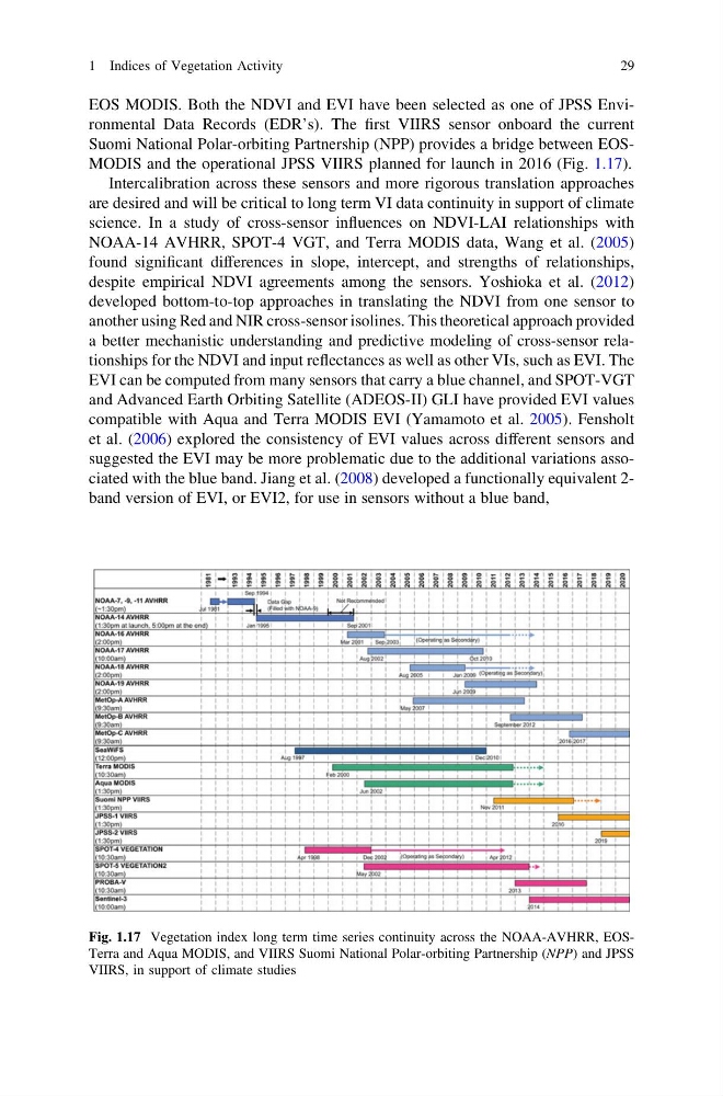
Suomi National Polar-orbiting Partnership (NPP) provides a bridge between EOSMODIS and the operational JPSS VIIRS planned for launch in 2016 (Fig. 1.17).
Intercalibration across these sensors and more rigorous translation approaches
are desired and will be critical to long term VI data continuity in support of climate
science. In a study of cross-sensor influences on NDVI-LAI relationships with
NOAA-14 AVHRR, SPOT-4 VGT, and Terra MODIS data, Wang et al. (2005)
found significant differences in slope, intercept, and strengths of relationships,
despite empirical NDVI agreements among the sensors. Yoshioka et al. (2012)
developed bottom-to-top approaches in translating the NDVI from one sensor to
another using Red and NIR cross-sensor isolines. This theoretical approach provided
a better mechanistic understanding and predictive modeling of cross-sensor relationships for the NDVI and input reflectances as well as other VIs, such as EVI. The
EVI can be computed from many sensors that carry a blue channel, and SPOT-VGT
and Advanced Earth Orbiting Satellite (ADEOS-II) GLI have provided EVI values
compatible with Aqua and Terra MODIS EVI (Yamamoto et al. 2005). Fensholt
et al. (2006) explored the consistency of EVI values across different sensors and
suggested the EVI may be more problematic due to the additional variations associated with the blue band. Jiang et al. (2008) developed a functionally equivalent 2band version of EVI, or EVI2, for use in sensors without a blue band,
Fig. 1.17 Vegetation index long term time series continuity across the NOAA-AVHRR, EOSTerra and Aqua MODIS, and VIIRS Suomi National Polar-orbiting Partnership (NPP) and JPSS
VIIRS, in support of climate studies
1 Indices of Vegetation Activity
29
Suomi National Polar-orbiting Partnership (NPP) provides a bridge between EOSMODIS and the operational JPSS VIIRS planned for launch in 2016 (Fig. 1.17).
Intercalibration across these sensors and more rigorous translation approaches
are desired and will be critical to long term VI data continuity in support of climate
science. In a study of cross-sensor influences on NDVI-LAI relationships with
NOAA-14 AVHRR, SPOT-4 VGT, and Terra MODIS data, Wang et al. (2005)
found significant differences in slope, intercept, and strengths of relationships,
despite empirical NDVI agreements among the sensors. Yoshioka et al. (2012)
developed bottom-to-top approaches in translating the NDVI from one sensor to
another using Red and NIR cross-sensor isolines. This theoretical approach provided
a better mechanistic understanding and predictive modeling of cross-sensor relationships for the NDVI and input reflectances as well as other VIs, such as EVI. The
EVI can be computed from many sensors that carry a blue channel, and SPOT-VGT
and Advanced Earth Orbiting Satellite (ADEOS-II) GLI have provided EVI values
compatible with Aqua and Terra MODIS EVI (Yamamoto et al. 2005). Fensholt
et al. (2006) explored the consistency of EVI values across different sensors and
suggested the EVI may be more problematic due to the additional variations associated with the blue band. Jiang et al. (2008) developed a functionally equivalent 2band version of EVI, or EVI2, for use in sensors without a blue band,
Fig. 1.17 Vegetation index long term time series continuity across the NOAA-AVHRR, EOSTerra and Aqua MODIS, and VIIRS Suomi National Polar-orbiting Partnership (NPP) and JPSS
VIIRS, in support of climate studies
1 Indices of Vegetation Activity
29