

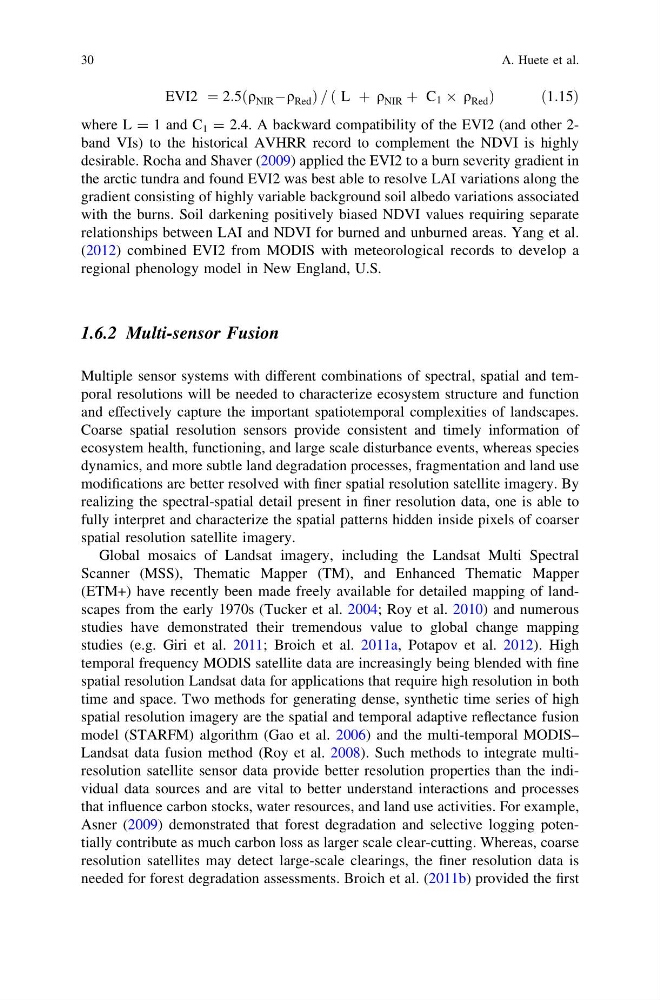
EVI2 ¼ 2:5 q NIR Àq Red
ð
Þ= L þ q NIR þ C 1 Â q Red
ð
Þ
ð 1:15Þ
where L = 1 and C 1 = 2.4. A backward compatibility of the EVI2 (and other 2band VIs) to the historical AVHRR record to complement the NDVI is highly
desirable. Rocha and Shaver (2009) applied the EVI2 to a burn severity gradient in
the arctic tundra and found EVI2 was best able to resolve LAI variations along the
gradient consisting of highly variable background soil albedo variations associated
with the burns. Soil darkening positively biased NDVI values requiring separate
relationships between LAI and NDVI for burned and unburned areas. Yang et al.
(2012) combined EVI2 from MODIS with meteorological records to develop a
regional phenology model in New England, U.S.
1.6.2 Multi-sensor Fusion
Multiple sensor systems with different combinations of spectral, spatial and temporal resolutions will be needed to characterize ecosystem structure and function
and effectively capture the important spatiotemporal complexities of landscapes.
Coarse spatial resolution sensors provide consistent and timely information of
ecosystem health, functioning, and large scale disturbance events, whereas species
dynamics, and more subtle land degradation processes, fragmentation and land use
modifications are better resolved with finer spatial resolution satellite imagery. By
realizing the spectral-spatial detail present in finer resolution data, one is able to
fully interpret and characterize the spatial patterns hidden inside pixels of coarser
spatial resolution satellite imagery.
Global mosaics of Landsat imagery, including the Landsat Multi Spectral
Scanner (MSS), Thematic Mapper (TM), and Enhanced Thematic Mapper
(ETM+) have recently been made freely available for detailed mapping of landscapes from the early 1970s (Tucker et al. 2004; Roy et al. 2010) and numerous
studies have demonstrated their tremendous value to global change mapping
studies (e.g. Giri et al. 2011; Broich et al. 2011a, Potapov et al. 2012). High
temporal frequency MODIS satellite data are increasingly being blended with fine
spatial resolution Landsat data for applications that require high resolution in both
time and space. Two methods for generating dense, synthetic time series of high
spatial resolution imagery are the spatial and temporal adaptive reflectance fusion
model (STARFM) algorithm (Gao et al. 2006) and the multi-temporal MODIS–
Landsat data fusion method (Roy et al. 2008). Such methods to integrate multiresolution satellite sensor data provide better resolution properties than the individual data sources and are vital to better understand interactions and processes
that influence carbon stocks, water resources, and land use activities. For example,
Asner (2009) demonstrated that forest degradation and selective logging potentially contribute as much carbon loss as larger scale clear-cutting. Whereas, coarse
resolution satellites may detect large-scale clearings, the finer resolution data is
needed for forest degradation assessments. Broich et al. (2011b) provided the first
30
A. Huete et al.
ð
Þ= L þ q NIR þ C 1 Â q Red
ð
Þ
ð 1:15Þ
where L = 1 and C 1 = 2.4. A backward compatibility of the EVI2 (and other 2band VIs) to the historical AVHRR record to complement the NDVI is highly
desirable. Rocha and Shaver (2009) applied the EVI2 to a burn severity gradient in
the arctic tundra and found EVI2 was best able to resolve LAI variations along the
gradient consisting of highly variable background soil albedo variations associated
with the burns. Soil darkening positively biased NDVI values requiring separate
relationships between LAI and NDVI for burned and unburned areas. Yang et al.
(2012) combined EVI2 from MODIS with meteorological records to develop a
regional phenology model in New England, U.S.
1.6.2 Multi-sensor Fusion
Multiple sensor systems with different combinations of spectral, spatial and temporal resolutions will be needed to characterize ecosystem structure and function
and effectively capture the important spatiotemporal complexities of landscapes.
Coarse spatial resolution sensors provide consistent and timely information of
ecosystem health, functioning, and large scale disturbance events, whereas species
dynamics, and more subtle land degradation processes, fragmentation and land use
modifications are better resolved with finer spatial resolution satellite imagery. By
realizing the spectral-spatial detail present in finer resolution data, one is able to
fully interpret and characterize the spatial patterns hidden inside pixels of coarser
spatial resolution satellite imagery.
Global mosaics of Landsat imagery, including the Landsat Multi Spectral
Scanner (MSS), Thematic Mapper (TM), and Enhanced Thematic Mapper
(ETM+) have recently been made freely available for detailed mapping of landscapes from the early 1970s (Tucker et al. 2004; Roy et al. 2010) and numerous
studies have demonstrated their tremendous value to global change mapping
studies (e.g. Giri et al. 2011; Broich et al. 2011a, Potapov et al. 2012). High
temporal frequency MODIS satellite data are increasingly being blended with fine
spatial resolution Landsat data for applications that require high resolution in both
time and space. Two methods for generating dense, synthetic time series of high
spatial resolution imagery are the spatial and temporal adaptive reflectance fusion
model (STARFM) algorithm (Gao et al. 2006) and the multi-temporal MODIS–
Landsat data fusion method (Roy et al. 2008). Such methods to integrate multiresolution satellite sensor data provide better resolution properties than the individual data sources and are vital to better understand interactions and processes
that influence carbon stocks, water resources, and land use activities. For example,
Asner (2009) demonstrated that forest degradation and selective logging potentially contribute as much carbon loss as larger scale clear-cutting. Whereas, coarse
resolution satellites may detect large-scale clearings, the finer resolution data is
needed for forest degradation assessments. Broich et al. (2011b) provided the first
30
A. Huete et al.