

1.6.1 VI Continuity and Long Term Data Records
The Intergovernmental Panel on Climate Change report (IPCC 2007) emphasized
the need to assess climate change impacts on forest resources through repeatable,
long term, and accurate satellite measures. VIs derived from the numerous Earth
Observing satellites partly fill this critical need by providing frequent temporal
satellite measurements that can be used to generate a seamless, long-term data
record for global change and climate change studies. Relative to more complex
satellite algorithms, VIs are more easily fused across multiple sensor systems
facilitating the underlying need to ensure continuity for long term monitoring
(Fig. 1.17).
Numerous investigations have empirically evaluated NDVI continuity and
consistency across AVHRR sensors (e.g. Los 1993; Roderick et al. 1996) and
confirmed the feasibility of NDVI translation across MODIS, SPOT-VGT, Seaviewing Wide Field-of-view Sensor (SeaWiFS), AVHRR, and the Landsat
ETM+ sensors (Fensholt 2004; Gallo et al. 2005; Gitelson and Kaufman 1998;
Miura et al. 2006; Trishchenko et al. 2002; Tucker et al. 2005; Yoshioka et al.
2012; van Leeuwen et al. 2006). The Visible Infrared Imaging Radiometer Suite
(VIIRS) instrument on the Joint Polar Satellite System (JPSS) program will extend
the VI data record of essential measurements begun by the NOAA-AVHRR and
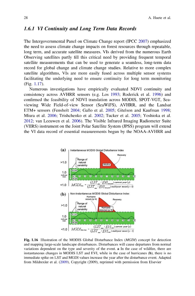
Fig. 1.16 Illustration of the MODIS Global Disturbance Index (MGDI) concept for detection
and mapping large-scale landscape disturbances. Disturbances will cause departures from normal
variations dependent on the type and severity of the event. a In the case of wildfire, there are
instantaneous changes in MODIS LST and EVI, while in the case of hurricanes (b), there is no
immediate spike on LST and MGDI values increase the year after the disturbance event. Adapted
from Mildrexler et al. (2009), Copyright (2009), reprinted with permission from Elsevier
28
A. Huete et al.
The Intergovernmental Panel on Climate Change report (IPCC 2007) emphasized
the need to assess climate change impacts on forest resources through repeatable,
long term, and accurate satellite measures. VIs derived from the numerous Earth
Observing satellites partly fill this critical need by providing frequent temporal
satellite measurements that can be used to generate a seamless, long-term data
record for global change and climate change studies. Relative to more complex
satellite algorithms, VIs are more easily fused across multiple sensor systems
facilitating the underlying need to ensure continuity for long term monitoring
(Fig. 1.17).
Numerous investigations have empirically evaluated NDVI continuity and
consistency across AVHRR sensors (e.g. Los 1993; Roderick et al. 1996) and
confirmed the feasibility of NDVI translation across MODIS, SPOT-VGT, Seaviewing Wide Field-of-view Sensor (SeaWiFS), AVHRR, and the Landsat
ETM+ sensors (Fensholt 2004; Gallo et al. 2005; Gitelson and Kaufman 1998;
Miura et al. 2006; Trishchenko et al. 2002; Tucker et al. 2005; Yoshioka et al.
2012; van Leeuwen et al. 2006). The Visible Infrared Imaging Radiometer Suite
(VIIRS) instrument on the Joint Polar Satellite System (JPSS) program will extend
the VI data record of essential measurements begun by the NOAA-AVHRR and
Fig. 1.16 Illustration of the MODIS Global Disturbance Index (MGDI) concept for detection
and mapping large-scale landscape disturbances. Disturbances will cause departures from normal
variations dependent on the type and severity of the event. a In the case of wildfire, there are
instantaneous changes in MODIS LST and EVI, while in the case of hurricanes (b), there is no
immediate spike on LST and MGDI values increase the year after the disturbance event. Adapted
from Mildrexler et al. (2009), Copyright (2009), reprinted with permission from Elsevier
28
A. Huete et al.